Trail Walking Vauxrenard - Itinérant Beaujolais rouge étape 6 Foretal - Macon gare TGV - Photo

Itinérant Beaujolais rouge étape 6 Foretal - Macon gare TGV

 chessyca
chessyca

User GUIDE

© OpenStreetMap contributors
Length
Length
23 km
Max alt
Max alt
381 m
Uphill gradient
Uphill gradient
372 m
Km-Effort
Km-Effort  
28 km
Min alt
Min alt
182 m
Downhill gradient
Downhill gradient
560 m
Boucle
Boucle
No
Creation date :
2023-10-21 06:43:30.589
Updated on :
2023-10-22 18:57:31.815

(0 Reviews)

Walking
Walking
6h26
Difficulty : Very difficult

Scan this QR Code to open this trail in the SityTrail application

FREE GPS app for hiking

Logo SityTrail SityTrail

IGN / Geographical institutes

Download SityTrail from the App Store Download SityTrail from Google Play

Logo SityTrail SityTrail World

The world is yours!

Download SityTrail from the App Store Download SityTrail from Google Play Download SityTrail on Huawei AppGallery

About

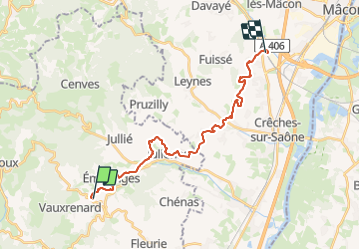
Trail Walking of 23 km to be discovered at Auvergne-Rhône-Alpes, Rhône, Vauxrenard. This trail is proposed by chessyca.

Description

Dernier jour du périple avec une étape cool  et touristique

Elevation profile

Photos

Positioning

Country:
France
Region :
Auvergne-Rhône-Alpes
Department/Province :
Rhône
Municipality :
Vauxrenard
Location:
Unknown
Start:(UTM)
628052 ; 5119133 (31T) N.

Trails nearby

Trail Walking Deux-Grosnes - Circuit de Saint-Jacques des Arrêts - Photo
Walking
tracegps

Walking

Medium
(1)
Deux-Grosnes, Auvergne-Rhône-Alpes, Rhône, France
11.9 km | 17.3 km-effort
3h 0min
Yes
Trail Walking Chiroubles - Itinérant Beaujolais rouge étape 5 Chiroubles- Foretal - Photo
Walking
GUIDE
chessyca

Walking

Medium
Chiroubles, Auvergne-Rhône-Alpes, Rhône, France
23 km | 32 km-effort
5h 44min
No
Trail Walking Beaujeu - Itinérant Beaujolais rouge étape 4 . Malval - Chiroubles - Photo
Walking
GUIDE
chessyca

Walking

Medium
Beaujeu, Auvergne-Rhône-Alpes, Rhône, France
26 km | 34 km-effort
5h 40min
No
Trail Walking Vauxrenard - vauxrenard - Photo
Walking
Zeugma13

Walking

Difficult
(1)
Vauxrenard, Auvergne-Rhône-Alpes, Rhône, France
21 km | 31 km-effort
5h 7min
Yes
Trail Walking Chénas - Chénas - Le Venet - Photo
Walking
jipysn

Walking

Very easy
Chénas, Auvergne-Rhône-Alpes, Rhône, France
3.4 km | 4.5 km-effort
1h 1min
Yes
Trail Walking Chiroubles - circuit des crêtes du fût d'Avenas - Photo
Walking
janussity

Walking

Difficult
Chiroubles, Auvergne-Rhône-Alpes, Rhône, France
13.8 km | 20 km-effort
3h 20min
Yes
Trail Walking Deux-Grosnes - Saint-Jacques-des-Arrêts (19 km - D. 630 m) - Photo
Walking
Thomasdanielle

Walking

Very difficult
Deux-Grosnes, Auvergne-Rhône-Alpes, Rhône, France
18.8 km | 27 km-effort
6h 10min
Yes
Trail Walking Chiroubles - 2023-05-26_00h30m21_28127-15675317-2 (2) - Photo
Walking
daniellebou

Walking

Very difficult
(1)
Chiroubles, Auvergne-Rhône-Alpes, Rhône, France
16.9 km | 26 km-effort
5h 49min
Yes
Trail Walking Fleurie - Fleurie (Rhône) 17 km - D. 498 m - Photo
Walking
Thomasdanielle

Walking

Medium
Fleurie, Auvergne-Rhône-Alpes, Rhône, France
16.7 km | 23 km-effort
5h 25min
Yes


Close
My subscriptions