Trail Walking Port-Vendres - PAULILLES COSPRONS MERCREDI FAIT  - Photo

PAULILLES COSPRONS MERCREDI FAIT

© OpenStreetMap contributors
Length
Length
9 km
Max alt
Max alt
60 m
Uphill gradient
Uphill gradient
129 m
Km-Effort
Km-Effort  
10.7 km
Min alt
Min alt
1 m
Downhill gradient
Downhill gradient
124 m
Boucle
Boucle
Yes
Creation date :
2024-01-05 08:50:53.341
Updated on :
2024-01-05 11:42:52.39

(1 Reviews)

Walking
Walking
2h26
Difficulty : Easy

Scan this QR Code to open this trail in the SityTrail application

FREE GPS app for hiking

Logo SityTrail SityTrail

IGN / Geographical institutes

Download SityTrail from the App Store Download SityTrail from Google Play

Logo SityTrail SityTrail World

The world is yours!

Download SityTrail from the App Store Download SityTrail from Google Play Download SityTrail on Huawei AppGallery

About

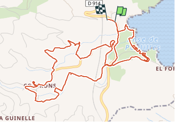
Trail Walking of 9 km to be discovered at Occitania, Pyrénées-Orientales, Port-Vendres. This trail is proposed by MarcOBRECHT.

Description

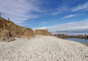
Paulilles, le site, COSPRONS, chapelle,

Elevation profile

Positioning

Country:
France
Region :
Occitania
Department/Province :
Pyrénées-Orientales
Municipality :
Port-Vendres
Location:
Unknown
Start:(UTM)
509910 ; 4705889 (31T) N.

Comments

Please log in to post a review or rate the element


Trails nearby

Trail Walking Port-Vendres - Le sentier des douaniers (Port-Vendres) - Photo
Walking
tracegps

Walking

Medium
(5)
Port-Vendres, Occitania, Pyrénées-Orientales, France
14.5 km | 19.1 km-effort
4h 0min
Yes
Trail Walking Collioure - Collioure-le racou - Photo
Walking
jeromelacoste

Walking

Medium
(1)
Collioure, Occitania, Pyrénées-Orientales, France
7.2 km | 9.3 km-effort
2h 1min
Yes
Trail Walking Collioure - 66 COLLIOURE - les balcons de Madeloc - circuit de la tour et des fortifications  - Photo
Walking
jeff66

Walking

Difficult
(1)
Collioure, Occitania, Pyrénées-Orientales, France
9.3 km | 14.9 km-effort
2h 4min
Yes
Trail Walking Port-Vendres - PORT-VENDRES 66 - Sentier littoral jusqu'à BANYULS-SUR-MER - retour par l'arrière pays et le vignoble - Photo
Walking
jeff66

Walking

Medium
(2)
Port-Vendres, Occitania, Pyrénées-Orientales, France
10.1 km | 14 km-effort
2h 21min
Yes
Trail Walking Banyuls-sur-Mer - BANYULS- SUR-MER 66 - Sentier littoral - cap Rederis - col de la Creu - Photo
Walking
jeff66

Walking

Difficult
(2)
Banyuls-sur-Mer, Occitania, Pyrénées-Orientales, France
15.1 km | 22 km-effort
3h 45min
Yes
Trail Walking Collioure - COLLIOURE 66 - Ermitage ND de consolation - tour MADELOC - Photo
Walking
jeff66

Walking

Difficult
(4)
Collioure, Occitania, Pyrénées-Orientales, France
14.7 km | 23 km-effort
3h 41min
Yes
Trail Walking Banyuls-sur-Mer - Littoral Banyuls-Cerbere - Photo
Walking
perittel

Walking

Medium
(1)
Banyuls-sur-Mer, Occitania, Pyrénées-Orientales, France
13.6 km | 18.8 km-effort
4h 33min
Yes
Trail Walking Port-Vendres - port vendres - Photo
Walking
perittel

Walking

Very easy
(1)
Port-Vendres, Occitania, Pyrénées-Orientales, France
10.9 km | 14.8 km-effort
3h 42min
Yes
Trail Walking Banyuls-sur-Mer - Banyuls Cerbère - Littoral retour bus - 10km 4h 320m déniv. - Photo
Walking
jopost

Walking

Difficult
(1)
Banyuls-sur-Mer, Occitania, Pyrénées-Orientales, France
10 km | 14.3 km-effort
4h 12min
No


Close
My subscriptions