Trail Walking Saulcy-sur-Meurthe - Taintrux (Massif du Kemberg)16 130m +589m (Alt 737m) - Photo

Taintrux (Massif du Kemberg)16 130m +589m (Alt 737m)

© OpenStreetMap contributors
Length
Length
16.1 km
Max alt
Max alt
737 m
Uphill gradient
Uphill gradient
589 m
Km-Effort
Km-Effort  
24 km
Min alt
Min alt
452 m
Downhill gradient
Downhill gradient
590 m
Boucle
Boucle
Yes
Creation date :
2024-03-10 07:30:42.477
Updated on :
2024-03-10 19:09:02.773

(0 Reviews)

Walking
Walking
5h27
Difficulty : Very difficult

Scan this QR Code to open this trail in the SityTrail application

FREE GPS app for hiking

Logo SityTrail SityTrail

IGN / Geographical institutes

Download SityTrail from the App Store Download SityTrail from Google Play

Logo SityTrail SityTrail World

The world is yours!

Download SityTrail from the App Store Download SityTrail from Google Play Download SityTrail on Huawei AppGallery

About

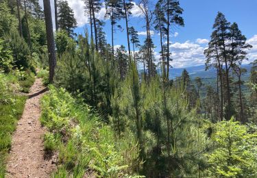
Trail Walking of 16.1 km to be discovered at Grand Est, Vosges, Saulcy-sur-Meurthe. This trail is proposed by DanielROLLET.

Description

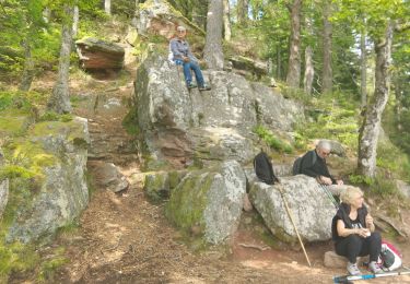
2024 03 10 - avec Marie - 8h35 à 14h40
Temps frais petite brise de nord. Début de pluie à l'arrivée
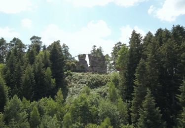
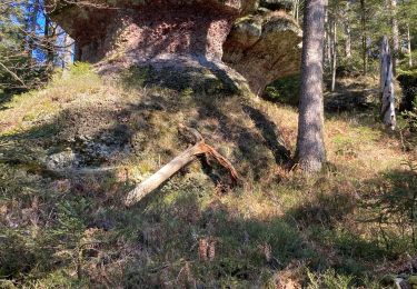
Départ/arrivée parking Croix Saint-Georges > Roche d'Anozel > La Pierre Percée > Roche du Kiosque > Roches saint-Martin > Rocher de l'Enclume.
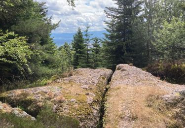
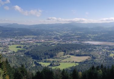
Beaux panoramas depuis les roches.
Mauvais choix au départ qui m'a contraint à modifier le circuit.

Elevation profile

Positioning

Country:
France
Region :
Grand Est
Department/Province :
Vosges
Municipality :
Saulcy-sur-Meurthe
Location:
Unknown
Start:(UTM)
346083 ; 5345626 (32U) N.

Trails nearby

Trail On foot Taintrux - GR de Pays de Déodatie - Photo
On foot
PRO

On foot

Easy
Taintrux, Grand Est, Vosges, France
7.9 km | 12.5 km-effort
2h 49min
No
Trail Walking Taintrux - suuntoapp-Hiking-2024-05-10T08-54-36Z - Photo
Walking
GUIDE
holtzv

Walking

Medium
Taintrux, Grand Est, Vosges, France
18.8 km | 32 km-effort
7h 14min
No
Trail Walking Saulcy-sur-Meurthe - Massif du KEMBERG - Photo
Walking
Dominique48

Walking

Very difficult
Saulcy-sur-Meurthe, Grand Est, Vosges, France
12.6 km | 20 km-effort
4h 45min
Yes
Trail Walking Taintrux - Marche 09-07-22 18Km - Photo
Walking
1957

Walking

Difficult
Taintrux, Grand Est, Vosges, France
15.4 km | 24 km-effort
4h 13min
Yes
Trail Walking Taintrux - Marche 06-06-22 24km - Photo
Walking
1957

Walking

Difficult
Taintrux, Grand Est, Vosges, France
23 km | 32 km-effort
5h 48min
Yes
Trail Walking Taintrux - Marche 25-05-22 18Km Climont  - Photo
Walking
1957

Walking

Difficult
Taintrux, Grand Est, Vosges, France
16 km | 27 km-effort
4h 50min
Yes
Trail Walking Taintrux - Marche 04-03-22 Gachotte - Photo
Walking
1957

Walking

Difficult
Taintrux, Grand Est, Vosges, France
16.2 km | 25 km-effort
4h 44min
Yes
Trail Walking Saint-Dié-des-Vosges - 2021-10-08 Marche St Die Metzeral Jour 1 - Photo
Walking
GUIDE
holtzv

Walking

Very difficult
Saint-Dié-des-Vosges, Grand Est, Vosges, France
26 km | 39 km-effort
7h 40min
No
Trail Walking Taintrux - Marche 17,5Km - Photo
Walking
1957

Walking

Difficult
Taintrux, Grand Est, Vosges, France
16.2 km | 25 km-effort
4h 41min
No


Close
My subscriptions