Trail Horseback riding Nompatelize - suuntoapp-HorsebackRiding-2024-04-13T07-02-45Z - Photo

suuntoapp-HorsebackRiding-2024-04-13T07-02-45Z

 holtzv
holtzv

User GUIDE

© OpenStreetMap contributors
Length
Length
28 km
Max alt
Max alt
652 m
Uphill gradient
Uphill gradient
700 m
Km-Effort
Km-Effort  
37 km
Min alt
Min alt
368 m
Downhill gradient
Downhill gradient
700 m
Boucle
Boucle
Yes
Creation date :
2024-04-15 09:52:24.982
Updated on :
2024-04-15 10:09:58.921

(1 Reviews)

Horseback riding
Horseback riding
4h54
Difficulty : Medium

Scan this QR Code to open this trail in the SityTrail application

FREE GPS app for hiking

Logo SityTrail SityTrail

IGN / Geographical institutes

Download SityTrail from the App Store Download SityTrail from Google Play

Logo SityTrail SityTrail World

The world is yours!

Download SityTrail from the App Store Download SityTrail from Google Play Download SityTrail on Huawei AppGallery

About

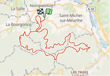
Trail Horseback riding of 28 km to be discovered at Grand Est, Vosges, Nompatelize. This trail is proposed by holtzv.

Description

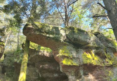
Boucle depuis le gite des Jumeaux à Feignes en direction du tour des petit et grand Jumeaux, la roche de Durand Pré, la roche des Hauts Champs, le site de départ de parapentes près de la tête de la Biche, la fontaine de la Solitude, la croix du rendez-vous pour la pause déjeuner, le col des Quatre Chemins, la croix Idoux, et le Haut de Thoné.

Attention, l’accès à la chaise du Roi ne passe pas à cheval.

Elevation profile

Photos

Positioning

Country:
France
Region :
Grand Est
Department/Province :
Vosges
Municipality :
Nompatelize
Location:
Unknown
Start:(UTM)
341195 ; 5353658 (32U) N.

Comments

Please log in to post a review or rate the element


Trails nearby

Trail Mountain bike Saint-Dié-des-Vosges - vtt la voivre La Bure 29-03-19 - Photo
Mountain bike
vathi54

Mountain bike

Difficult
(2)
Saint-Dié-des-Vosges, Grand Est, Vosges, France
20 km | 28 km-effort
2h 48min
Yes
Trail Walking Saint-Michel-sur-Meurthe - massif de la madeleine  - Photo
Walking
remysimon

Walking

Medium
(1)
Saint-Michel-sur-Meurthe, Grand Est, Vosges, France
14.7 km | 22 km-effort
4h 10min
Yes
Trail Mountain bike La Bourgonce - sortie vtt du 07042019 la bourgonce - Photo
Mountain bike
GUIDE
fabwin

Mountain bike

Difficult
La Bourgonce, Grand Est, Vosges, France
31 km | 42 km-effort
2h 48min
Yes
Trail Mountain bike La Bourgonce - vtt à Bourgonce 26 juin 2016 - Photo
Mountain bike
vathi54

Mountain bike

Very easy
(2)
La Bourgonce, Grand Est, Vosges, France
31 km | 42 km-effort
3h 39min
Yes
Trail Walking Saint-Dié-des-Vosges - Autour de CAP FRANCE LA BOLLE VOSGES - Photo
Walking
Dominique48

Walking

Medium
Saint-Dié-des-Vosges, Grand Est, Vosges, France
5.9 km | 8.8 km-effort
2h 14min
No
Trail On foot Saint-Michel-sur-Meurthe - Circuit du Grand Jumeau - Photo
On foot
PRO

On foot

Easy
Saint-Michel-sur-Meurthe, Grand Est, Vosges, France
3.7 km | 5.8 km-effort
1h 18min
Yes
Trail On foot Les Rouges-Eaux - circuit poussettes du col du Haut Jacques  - Photo
On foot
salomé

On foot

Easy
Les Rouges-Eaux, Grand Est, Vosges, France
1.4 km | 1.6 km-effort
21min
Yes
Trail Mountain bike Saint-Dié-des-Vosges - sortie vtt du 31032019 - Photo
Mountain bike
GUIDE
fabwin

Mountain bike

Medium
Saint-Dié-des-Vosges, Grand Est, Vosges, France
18.6 km | 0 m-effort
1h 41min
Yes
Trail Mountain bike La Bourgonce - rando des  jumeaux 2016 - Photo
Mountain bike
GUIDE
fabwin

Mountain bike

Difficult
La Bourgonce, Grand Est, Vosges, France
30 km | 41 km-effort
2h 39min
Yes


Close
My subscriptions