Trail Walking Senlis - rando bivouac - Photo
 doloop
doloop

User

© OpenStreetMap contributors
Length
Length
21 km
Max alt
Max alt
114 m
Uphill gradient
Uphill gradient
193 m
Km-Effort
Km-Effort  
23 km
Min alt
Min alt
50 m
Downhill gradient
Downhill gradient
203 m
Boucle
Boucle
No
Creation date :
2015-04-08 00:00:00.0
Updated on :
2015-04-08 00:00:00.0

(0 Reviews)

Walking
Walking
5h04
Difficulty : Unknown

Scan this QR Code to open this trail in the SityTrail application

FREE GPS app for hiking

Logo SityTrail SityTrail

IGN / Geographical institutes

Download SityTrail from the App Store Download SityTrail from Google Play

Logo SityTrail SityTrail World

The world is yours!

Download SityTrail from the App Store Download SityTrail from Google Play Download SityTrail on Huawei AppGallery

About

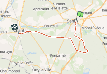
Trail Walking of 21 km to be discovered at Hauts-de-France, Oise, Senlis. This trail is proposed by doloop.

Description

Départ gare de chantilly, prendre bus N°15 (19h40) jusqu'à senlis gare routière.

Elevation profile

Positioning

Country:
France
Region :
Hauts-de-France
Department/Province :
Oise
Municipality :
Senlis
Location:
Unknown
Start:(UTM)
470306 ; 5450477 (31U) N.

Trails nearby

Trail Walking Villers-Saint-Frambourg-Ognon - MR_OGNON (par BALAGNY-sur-AUNETTE)_5.4Km - Photo
Walking

Walking

Medium
(3)
Villers-Saint-Frambourg-Ognon, Hauts-de-France, Oise, France
5.4 km | 6.4 km-effort
1h 27min
Yes
Trail Walking Senlis - SM_ERMENONVILLE Mais Forest BIAT_7.9Km - Photo
Walking
GR77LP

Walking

Medium
(2)
Senlis, Hauts-de-France, Oise, France
7.9 km | 8.9 km-effort
2h 1min
Yes
Trail Walking Mont-l'Évêque - SM_MONT-L'EVEQUE_8Km - Photo
Walking
GR77LP

Walking

Medium
(4)
Mont-l'Évêque, Hauts-de-France, Oise, France
8.1 km | 9.1 km-effort
1h 59min
Yes
Trail On foot Senlis - SENLIS CITE ROYALE(FFK) - Photo
On foot
GR77LP

On foot

Very easy
(1)
Senlis, Hauts-de-France, Oise, France
4.6 km | 5.2 km-effort
2h 0min
Yes
Trail Walking Chamant - Chamant Supermini-rando - Photo
Walking
CC.RIDER

Walking

Easy
(8)
Chamant, Hauts-de-France, Oise, France
8 km | 9.3 km-effort
2h 7min
Yes
Trail On foot Senlis - De Orrouy à Coye - Photo
On foot
PRO

On foot

Easy
Senlis, Hauts-de-France, Oise, France
10.1 km | 11.2 km-effort
2h 33min
No
Trail On foot Aumont-en-Halatte - Chemin Royal - Photo
On foot
PRO

On foot

Easy
Aumont-en-Halatte, Hauts-de-France, Oise, France
3.5 km | 4 km-effort
54min
No
Trail Walking Villers-Saint-Frambourg-Ognon - SM_OGNON-(ex BALAGNY-sur-AUNETTE)_8.3Km - Photo
Walking
GR77LP

Walking

Medium
(4)
Villers-Saint-Frambourg-Ognon, Hauts-de-France, Oise, France
8.3 km | 9.6 km-effort
2h 10min
Yes
Trail Walking Pontarmé - La Croix de Pontarmé_Le chêne de grès_trace GPS_9,6km - Photo
Walking
Pousscailleux

Walking

Easy
Pontarmé, Hauts-de-France, Oise, France
9.6 km | 10.7 km-effort
2h 37min
Yes


Close
My subscriptions