


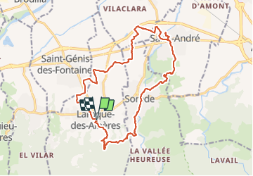
LAROQUE- SOREDE- ST_ANDRE- ST_GENIS

jeff66
User

Length
21 km

Max alt
218 m

Uphill gradient
237 m
Km-Effort
24 km

Min alt
26 m

Downhill gradient
238 m
Boucle
Yes
Creation date :
2015-04-08 00:00:00.0
Updated on :
2015-04-08 00:00:00.0
3h19
Difficulty : Easy

FREE GPS app for hiking
 SityTrail
IGN / Geographical institutes
SityTrail Plus
The world is yours!
About
Trail Walking of 21 km to be discovered at Occitania, Pyrénées-Orientales, Laroque-des-Albères. This trail is proposed by jeff66.
Description
LAROQUE - SOREDE par la route des mas et RIVIERE de sorede- saint André par la MILLOSSA - ST génis par la plaine
Points of interest


Positioning
Country:
France
Region :
Occitania
Department/Province :
Pyrénées-Orientales
Municipality :
Laroque-des-Albères
Location:
Unknown
Start:(Dec)
Start:(UTM)
494735 ; 4707812 (31T) N.
Comments