


Lescun Estou

taguette
User
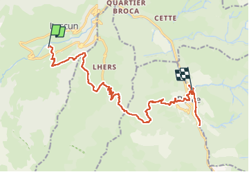

Length
20 km

Max alt
1610 m

Uphill gradient
916 m
Km-Effort
33 km

Min alt
592 m

Downhill gradient
1175 m
Boucle
No
Creation date :
2024-08-04 06:29:25.864
Updated on :
2024-08-04 16:50:23.236
8h19
Difficulty : Very difficult

FREE GPS app for hiking
 SityTrail
IGN / Geographical institutes
SityTrail Plus
The world is yours!
About
Trail Walking of 20 km to be discovered at New Aquitaine, Pyrénées-Atlantiques, Lescun. This trail is proposed by taguette.
Positioning
Country:
France
Region :
New Aquitaine
Department/Province :
Pyrénées-Atlantiques
Municipality :
Lescun
Location:
Unknown
Start:(Dec)
Start:(UTM)
692392 ; 4755518 (30T) N.
Comments