


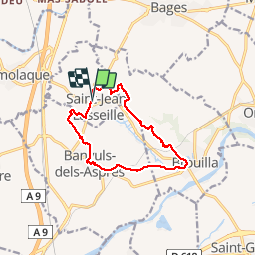
ST-JEAN-LASSEILLE 66 - terroirs des Aspres

jeff66
User


2h06
Difficulty : Easy

FREE GPS app for hiking
 SityTrail
IGN / Geographical institutes
SityTrail Plus
The world is yours!
About
Trail Walking of 12.2 km to be discovered at Occitania, Pyrénées-Orientales, Saint-Jean-Lasseille. This trail is proposed by jeff66.
Description
ST-JEAN-LASSEILLE 66 - chateau Montana - par les vignes - Banyuls dels Aspres - église St André - place de la République - cave Coop - vue sur les Albères - Brouilla par la plaine et le vignoble - passages à gué - école - salle polyvalente - cimetière - vue sur brouilla la plaine les Albères - panorama sur Perpignan - chateau Planères - St jean lasseille - cimetière
Photos


Positioning
Comments