


2024 Toussaint J03

Airelle
User
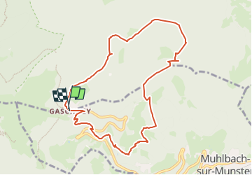

Length
9.3 km

Max alt
998 m

Uphill gradient
434 m
Km-Effort
15.1 km

Min alt
781 m

Downhill gradient
440 m
Boucle
Yes
Creation date :
2024-09-28 18:18:11.899
Updated on :
2024-09-28 18:25:35.516
3h26
Difficulty : Difficult

FREE GPS app for hiking
 SityTrail
IGN / Geographical institutes
SityTrail Plus
The world is yours!
About
Trail Walking of 9.3 km to be discovered at Grand Est, Haut-Rhin, Stosswihr. This trail is proposed by Airelle.
Positioning
Country:
France
Region :
Grand Est
Department/Province :
Haut-Rhin
Municipality :
Stosswihr
Location:
Unknown
Start:(Dec)
Start:(UTM)
354364 ; 5321995 (32U) N.
Comments