


Rando Bitschwiller les Thann 20 km...D+/- : 940 m

boubou68
User
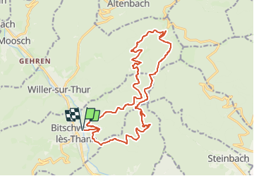

Length
20 km

Max alt
948 m

Uphill gradient
941 m
Km-Effort
33 km

Min alt
358 m

Downhill gradient
941 m
Boucle
Yes
Creation date :
2025-06-22 15:14:56.185
Updated on :
2025-06-22 15:19:04.707
7h29
Difficulty : Difficult
7h29
Difficulty : Very difficult

FREE GPS app for hiking
 SityTrail
IGN / Geographical institutes
SityTrail Plus
The world is yours!
About
Trail On foot of 20 km to be discovered at Grand Est, Haut-Rhin, Bitschwiller-lès-Thann. This trail is proposed by boubou68.
Description
Une classique ombragéée !
Positioning
Country:
France
Region :
Grand Est
Department/Province :
Haut-Rhin
Municipality :
Bitschwiller-lès-Thann
Location:
Unknown
Start:(Dec)
Start:(UTM)
356487 ; 5299227 (32T) N.
Comments