


Rando Gashney - Hohneck

OxygenLT
User
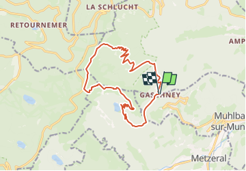

Length
15.1 km

Max alt
1355 m

Uphill gradient
661 m
Km-Effort
24 km

Min alt
851 m

Downhill gradient
663 m
Boucle
Yes
Creation date :
2025-07-16 18:20:52.721
Updated on :
2025-07-16 18:22:48.944
5h25
Difficulty : Very difficult

FREE GPS app for hiking
 SityTrail
IGN / Geographical institutes
SityTrail Plus
The world is yours!
About
Trail Walking of 15.1 km to be discovered at Grand Est, Haut-Rhin, Stosswihr. This trail is proposed by OxygenLT.
Positioning
Country:
France
Region :
Grand Est
Department/Province :
Haut-Rhin
Municipality :
Stosswihr
Location:
Unknown
Start:(Dec)
Start:(UTM)
354385 ; 5321973 (32U) N.
Comments