


Reco Gashney - Hohneck

OxygenLT
User
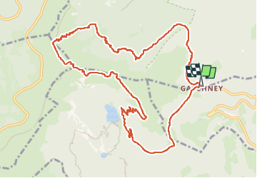

Length
12.9 km

Max alt
1355 m

Uphill gradient
570 m
Km-Effort
20 km

Min alt
944 m

Downhill gradient
575 m
Boucle
Yes
Creation date :
2025-07-16 12:27:32.913
Updated on :
2025-07-17 05:09:51.168
3h26
Difficulty : Difficult

FREE GPS app for hiking
 SityTrail
IGN / Geographical institutes
SityTrail Plus
The world is yours!
About
Trail Walking of 12.9 km to be discovered at Grand Est, Haut-Rhin, Stosswihr. This trail is proposed by OxygenLT.
Positioning
Country:
France
Region :
Grand Est
Department/Province :
Haut-Rhin
Municipality :
Stosswihr
Location:
Unknown
Start:(Dec)
Start:(UTM)
354321 ; 5321956 (32U) N.
Comments