


Camp 2025 - Lac Vert

norbertmarteau
User
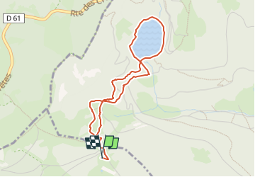

Length
3.9 km

Max alt
1131 m

Uphill gradient
130 m
Km-Effort
5.7 km

Min alt
1045 m

Downhill gradient
130 m
Boucle
Yes
Creation date :
2025-07-27 14:12:40.137
Updated on :
2025-07-27 14:15:15.997
1h17
Difficulty : Easy

FREE GPS app for hiking
 SityTrail
IGN / Geographical institutes
SityTrail Plus
The world is yours!
About
Trail Walking of 3.9 km to be discovered at Grand Est, Haut-Rhin, Stosswihr. This trail is proposed by norbertmarteau.
Description
Etape 1 - 4 km 130 m
Positioning
Country:
France
Region :
Grand Est
Department/Province :
Haut-Rhin
Municipality :
Stosswihr
Location:
Unknown
Start:(Dec)
Start:(UTM)
355386 ; 5326906 (32U) N.
Comments