


Camp 2025 - Lac blanc depuis le Chalet

norbertmarteau
User
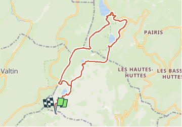

Length
18.1 km

Max alt
1300 m

Uphill gradient
746 m
Km-Effort
28 km

Min alt
952 m

Downhill gradient
746 m
Boucle
Yes
Creation date :
2025-08-06 20:51:23.409
Updated on :
2025-08-06 20:52:24.546
6h21
Difficulty : Very difficult

FREE GPS app for hiking
 SityTrail
IGN / Geographical institutes
SityTrail Plus
The world is yours!
About
Trail Walking of 18.1 km to be discovered at Grand Est, Haut-Rhin, Stosswihr. This trail is proposed by norbertmarteau.
Positioning
Country:
France
Region :
Grand Est
Department/Province :
Haut-Rhin
Municipality :
Stosswihr
Location:
Unknown
Start:(Dec)
Start:(UTM)
355381 ; 5326901 (32U) N.
Comments