Trail Walking Vauvert - 30 VAUVERT - GR653 - chemin d'Arles - FRANQUEVAUX - d'un canal a l'autre - GALLICIAN  - ch. des Coquillons - Photo

30 VAUVERT - GR653 - chemin d'Arles - FRANQUEVAUX - d'un canal a l'autre - GALLICIAN - ch. des Coquillons

 jeff66
jeff66

User

© OpenStreetMap contributors
Length
Length
28 km
Max alt
Max alt
78 m
Uphill gradient
Uphill gradient
241 m
Km-Effort
Km-Effort  
31 km
Min alt
Min alt
-4 m
Downhill gradient
Downhill gradient
242 m
Boucle
Boucle
Yes
Creation date :
2015-08-16 00:00:00.0
Updated on :
2015-08-16 00:00:00.0

(0 Reviews)

Walking
Walking
5h01
Difficulty : Difficult

Scan this QR Code to open this trail in the SityTrail application

FREE GPS app for hiking

Logo SityTrail SityTrail

IGN / Geographical institutes

Download SityTrail from the App Store Download SityTrail from Google Play

Logo SityTrail SityTrail World

The world is yours!

Download SityTrail from the App Store Download SityTrail from Google Play Download SityTrail on Huawei AppGallery

About

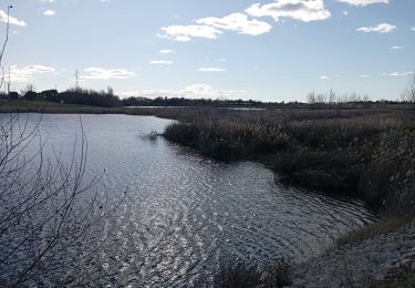
Trail Walking of 28 km to be discovered at Occitania, Gard, Vauvert. This trail is proposed by jeff66.

Description

30 VAUVERT - parking ctre cial Carrefour, la Condamine, - P.Le Cournier - GR 653 , chemin d'Arles, cabane de Magnan, P. Et voie dite du laquer de Fenestralle, cabanes de belle vue, P.Mas de Graille, P.Bergerie, P.Le Valladas, P.Beau bois, canal BRL PH. Lamour, P.St Jacques - D6572 - le cougourlier, les pointes - la Palusette, FRANQUEVAUX - pont sur canal du Rhône a Sète - port de plaisance, halte nautique de GALLICIAN - Via Rhona - P.la Laune - P.mas Tessier - P.bas Coquillon, chemins des Coquillons- Scamandre fond. Yves Rocher - mas du petit Bourry - les clochettes - P.Ht Coquillon - P.Mas des Mongettes - P.Contensargues - Valaure - Puech Causen - piste cyclable le long du canal BRL - VAUVERT - P.la Condamine -
P.la vallée verte -

Elevation profile

Photos

29 photos in total. Please click on a photo to see them all in the gallery.

Positioning

Country:
France
Region :
Occitania
Department/Province :
Gard
Municipality :
Vauvert
Location:
Unknown
Start:(UTM)
602637 ; 4838152 (31T) N.

Trails nearby

Trail Walking Vauvert - Vauvert - Villetelle - Photo
Walking
RR31

Walking

Medium
(1)
Vauvert, Occitania, Gard, France
22 km | 23 km-effort
6h 51min
No
Trail Walking Vauvert - Vauvert Les escaliers  de verre - Photo
Walking
Ptitjack30

Walking

Easy
(1)
Vauvert, Occitania, Gard, France
7.1 km | 8.4 km-effort
1h 37min
Yes
Trail Walking Le Cailar - cailar-costieres-camargues - Photo
Walking
v.rabot

Walking

Medium
Le Cailar, Occitania, Gard, France
20 km | 22 km-effort
4h 0min
Yes
Trail Hybrid bike Vauvert - 2020-01-29_15h48m07_10922156-track-1580309276-692 - Photo
Hybrid bike
gadafo

Hybrid bike

Very easy
(1)
Vauvert, Occitania, Gard, France
50 km | 52 km-effort
Unknown
Yes
Trail Walking Beauvoisin - 30 BEAUVOISIN, promenade dans les Costières de Nîmes, Entre Pinèdes, vignes, mas et vergers  - Photo
Walking
jeff66

Walking

Medium
Beauvoisin, Occitania, Gard, France
22 km | 25 km-effort
3h 51min
Yes
Trail Walking Le Cailar - Le Cailar - Photo
Walking
guyzinz

Walking

Very difficult
Le Cailar, Occitania, Gard, France
15.6 km | 16.8 km-effort
4h 3min
Yes
Trail Walking Vergèze - Étangs de Vergèze le 20 01 2023 - Photo
Walking
jesusmarieclaire

Walking

Very easy
Vergèze, Occitania, Gard, France
7 km | 7.5 km-effort
1h 43min
Yes
Trail Hybrid bike Beauvoisin - cailar canal bas rhone - Photo
Hybrid bike
GEHAN Alain

Hybrid bike

Easy
Beauvoisin, Occitania, Gard, France
33 km | 35 km-effort
3h 19min
Yes
Trail Walking Beauvoisin - Beauvoisin - Listerne - Photo
Walking
rando30129

Walking

Medium
Beauvoisin, Occitania, Gard, France
7.9 km | 9.4 km-effort
2h 1min
Yes


Close
My subscriptions