


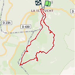
Sentier des roches

PascalBanide
User

Length
9.9 km

Max alt
1298 m

Uphill gradient
458 m
Km-Effort
15.9 km

Min alt
964 m

Downhill gradient
452 m
Boucle
Yes
Creation date :
2015-09-22 00:00:00.0
Updated on :
2015-09-22 00:00:00.0
5h06
Difficulty : Difficult

FREE GPS app for hiking
 SityTrail
IGN / Geographical institutes
SityTrail Plus
The world is yours!
About
Trail Other activity of 9.9 km to be discovered at Grand Est, Haut-Rhin, Stosswihr. This trail is proposed by PascalBanide.
Description
Dans les Vosges
Positioning
Country:
France
Region :
Grand Est
Department/Province :
Haut-Rhin
Municipality :
Stosswihr
Location:
Unknown
Start:(Dec)
Start:(UTM)
352841 ; 5325241 (32U) N.
Comments