Trail Walking Perpignan - 66 PERPIGNAN, Ch. de STE BARBE, Mailloles, quartier des aviateurs, Serrat d'en Vaquer - Photo

66 PERPIGNAN, Ch. de STE BARBE, Mailloles, quartier des aviateurs, Serrat d'en Vaquer

 jeff66
jeff66

User

© OpenStreetMap contributors
Length
Length
8 km
Max alt
Max alt
85 m
Uphill gradient
Uphill gradient
106 m
Km-Effort
Km-Effort  
9.4 km
Min alt
Min alt
35 m
Downhill gradient
Downhill gradient
106 m
Boucle
Boucle
Yes
Creation date :
2015-12-08 00:00:00.0
Updated on :
2015-12-08 00:00:00.0

(0 Reviews)

Walking
Walking
1h29
Difficulty : Easy

Scan this QR Code to open this trail in the SityTrail application

FREE GPS app for hiking

Logo SityTrail SityTrail

IGN / Geographical institutes

Download SityTrail from the App Store Download SityTrail from Google Play

Logo SityTrail SityTrail World

The world is yours!

Download SityTrail from the App Store Download SityTrail from Google Play Download SityTrail on Huawei AppGallery

About

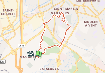
Trail Walking of 8 km to be discovered at Occitania, Pyrénées-Orientales, Perpignan. This trail is proposed by jeff66.

Description

66 PERPIGNAN, Ch. de STE BARBE, domaine Sarda Mallet, carré royal immobilier, passage sous le pont sainte Marie de Mailloles et chemin de Mailloles, centre commercial E.Leclerc, av. Fernand de Chefdebien, Bld Nugesser et Coli, rues E. Blériot, H. BOUCHET, M. Bastié, résidence les villages d'or, canal De Perpignan, les Arcades, la villa Duflot, rond point A.Donnezan, fort du Serrat d'en Vaquer

Elevation profile

Photos

Positioning

Country:
France
Region :
Occitania
Department/Province :
Pyrénées-Orientales
Municipality :
Perpignan
Location:
Unknown
Start:(UTM)
489374 ; 4723902 (31T) N.

Trails nearby

Trail Walking Montescot - 66 VILLENEUVE-DE-LA-RAHO grand tour du lac en Sens horaire  - Photo
Walking
jeff66

Walking

Easy
(1)
Montescot, Occitania, Pyrénées-Orientales, France
6.7 km | 7.5 km-effort
1h 4min
Yes
Trail Walking Perpignan - Perpignan 01.10.2017  - Photo
Walking
jeff66

Walking

Easy
(1)
Perpignan, Occitania, Pyrénées-Orientales, France
6.7 km | 7.5 km-effort
1h 39min
No
Trail Walking Villeneuve-de-la-Raho - 66 VILLENEUVE-DE-LA-RAHO - grand tour périphérique du lac par les lignes de crêtes  - Photo
Walking
jeff66

Walking

Easy
(2)
Villeneuve-de-la-Raho, Occitania, Pyrénées-Orientales, France
10 km | 11.5 km-effort
1h 44min
Yes
Trail Mountain bike Canohès - canohes - Photo
Mountain bike
haroldtheviking

Mountain bike

Medium
(2)
Canohès, Occitania, Pyrénées-Orientales, France
37 km | 44 km-effort
2h 12min
Yes
Trail Walking Perpignan - Perpignan  - Photo
Walking
ombrabella

Walking

Very easy
Perpignan, Occitania, Pyrénées-Orientales, France
18 km | 19.9 km-effort
2h 23min
No
Trail Walking Perpignan - canal Perpignan  - Photo
Walking
Fildesir

Walking

Very easy
Perpignan, Occitania, Pyrénées-Orientales, France
25 km | 27 km-effort
7h 29min
No
Trail Walking Perpignan - 66 PERPIGNAN, quartier MAV au Bas Vernet  - Photo
Walking
jeff66

Walking

Easy
Perpignan, Occitania, Pyrénées-Orientales, France
10.7 km | 11.8 km-effort
1h 45min
Yes
Trail Walking Perpignan - 66 Perpignan Panchot centre bas Vernet centre del mon - Photo
Walking
jeff66

Walking

Easy
Perpignan, Occitania, Pyrénées-Orientales, France
8.6 km | 9.3 km-effort
1h 29min
Yes
Trail Walking Montescot - 66 VILLENEUVE-DE-LA-RAHO grand tour du lac en Sens horaire  - Photo
Walking
jeff66

Walking

Easy
Montescot, Occitania, Pyrénées-Orientales, France
6.7 km | 7.5 km-effort
1h 4min
Yes


Close
My subscriptions