


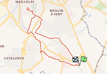

6.7 km | 7.5 km-effort


User


FREE GPS app for hiking
 SityTrail
IGN / Geographical institutes
SityTrail World
The world is yours!
Trail Walking of 10.4 km to be discovered at Occitania, Pyrénées-Orientales, Perpignan. This trail is proposed by jeff66.
66 PERPIGNAN, parking à proximité du mas San Teresa, piste cyclable le long du canal et de la voie ferrée, passer sous la RN14, puis à proximité de Jardiland, puis du hameau DANTJOU au mas Balande, puis mas Gaffard, el Pontet de BAGES, ch. de la Passio viella, rond point des arcades, Bld Nungesser et Coli, rue L. Blériot, longer canal de Perpignan, aqueduc, ch. de la Fauceille, rue F.Broussais, prendre chemin en contrebas de la RN114, porte d'Espagne, mas Eycheynne Gran, Agrosud, rambla Hélios, rue Ouranos, mas Delfau

Walking

Walking

Walking

Walking
Walking
Walking
Quad
Walking

Walking