Trail Walking Eyne - Eyne,col de Nuria,pic d'Eyne,Torre d'Eyne,Eyne. - Photo

Eyne,col de Nuria,pic d'Eyne,Torre d'Eyne,Eyne.

 Machaon6
Machaon6

User

© OpenStreetMap contributors
Length
Length
24 km
Max alt
Max alt
2810 m
Uphill gradient
Uphill gradient
1437 m
Km-Effort
Km-Effort  
43 km
Min alt
Min alt
1584 m
Downhill gradient
Downhill gradient
1437 m
Boucle
Boucle
Yes
Creation date :
2018-01-11 00:00:00.0
Updated on :
2018-01-11 00:00:00.0

(1 Reviews)

Walking
Walking
8h44
Difficulty : Very difficult

Scan this QR Code to open this trail in the SityTrail application

FREE GPS app for hiking

Logo SityTrail SityTrail

IGN / Geographical institutes

Download SityTrail from the App Store Download SityTrail from Google Play

Logo SityTrail SityTrail World

The world is yours!

Download SityTrail from the App Store Download SityTrail from Google Play Download SityTrail on Huawei AppGallery

About

Trail Walking of 24 km to be discovered at Occitania, Pyrénées-Orientales, Eyne. This trail is proposed by Machaon6.

Description

Départ parking de la réserve-1600m

Elevation profile

Photos

Positioning

Country:
France
Region :
Occitania
Department/Province :
Pyrénées-Orientales
Municipality :
Eyne
Location:
Unknown
Start:(UTM)
424505 ; 4702335 (31T) N.

Comments

Please log in to post a review or rate the element


très pratique


Trails nearby

Trail Snowshoes Font-Romeu-Odeillo-Via - pic dels moros - Photo
Snowshoes
jpipacific

Snowshoes

Medium
(1)
Font-Romeu-Odeillo-Via, Occitania, Pyrénées-Orientales, France
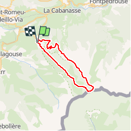
12.6 km | 19.4 km-effort
4h 46min
Yes
Trail Walking Font-Romeu-Odeillo-Via - Font Romeu Egat - Photo
Walking
crijack

Walking

Medium
(2)
Font-Romeu-Odeillo-Via, Occitania, Pyrénées-Orientales, France
2.5 km | 3.4 km-effort
44min
Yes
Trail Snowshoes Font-Romeu-Odeillo-Via - Pic dels Moros avec Pierre - Photo
Snowshoes
jpipacific

Snowshoes

Medium
(1)
Font-Romeu-Odeillo-Via, Occitania, Pyrénées-Orientales, France
10.5 km | 15.9 km-effort
4h 4min
Yes
Trail Walking Planès - étang de Planès - Photo
Walking
fhascoet

Walking

Medium
(2)
Planès, Occitania, Pyrénées-Orientales, France
10.8 km | 19.6 km-effort
3h 54min
No
Trail Walking Égat - La croix d'Egat - Photo
Walking
ochamley

Walking

Easy
(1)
Égat, Occitania, Pyrénées-Orientales, France
7.1 km | 10.4 km-effort
2h 2min
Yes
Trail Walking Eyne - Le Cambre d'Ase - Photo
Walking
tracegps

Walking

Difficult
(1)
Eyne, Occitania, Pyrénées-Orientales, France
8.9 km | 22 km-effort
4h 0min
Yes
Trail Mountain bike Font-Romeu-Odeillo-Via - Espace VTT FFC Pyrénées Catalanes - Circuit n° 6 - Forêt d'Egat - Photo
Mountain bike
tracegps

Mountain bike

Medium
(2)
Font-Romeu-Odeillo-Via, Occitania, Pyrénées-Orientales, France
7.6 km | 10.1 km-effort
1h 0min
Yes
Trail Walking Eyne - Vallée d'Eyne - Photo
Walking
GUIDE
nadinebondoux

Walking

Medium
Eyne, Occitania, Pyrénées-Orientales, France
10.7 km | 17.6 km-effort
4h 40min
Yes
Trail Walking Saint-Pierre-dels-Forcats - bains  de St Thomas  - Photo
Walking
Ptitjack30

Walking

Medium
(1)
Saint-Pierre-dels-Forcats, Occitania, Pyrénées-Orientales, France
8.6 km | 12.2 km-effort
2h 42min
No


Close
My subscriptions