Trail Walking Perpignan - 66 PERPIGNAN - MAV aviateurs - ST MARTIN - palais des rois de Majorque - St Vicens, St Gaudérique - Photo

66 PERPIGNAN - MAV aviateurs - ST MARTIN - palais des rois de Majorque - St Vicens, St Gaudérique

 jeff66
jeff66

User

© OpenStreetMap contributors
Length
Length
8.6 km
Max alt
Max alt
64 m
Uphill gradient
Uphill gradient
74 m
Km-Effort
Km-Effort  
9.6 km
Min alt
Min alt
35 m
Downhill gradient
Downhill gradient
74 m
Boucle
Boucle
Yes
Creation date :
2016-03-09 00:00:00.0
Updated on :
2016-03-09 00:00:00.0

(0 Reviews)

Walking
Walking
1h33
Difficulty : Easy

Scan this QR Code to open this trail in the SityTrail application

FREE GPS app for hiking

Logo SityTrail SityTrail

IGN / Geographical institutes

Download SityTrail from the App Store Download SityTrail from Google Play

Logo SityTrail SityTrail World

The world is yours!

Download SityTrail from the App Store Download SityTrail from Google Play Download SityTrail on Huawei AppGallery

About

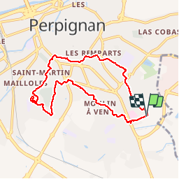
Trail Walking of 8.6 km to be discovered at Occitania, Pyrénées-Orientales, Perpignan. This trail is proposed by jeff66.

Description

66 PERPIGNAN - MAV, rues de port vendres, du RÉART, d'alenya, de Montescot, Bld du Foment de la Sardane, rue de Palalda, place du Canigou, av. Paul Alduy, rues C-D. Hortola, du Béarn, av. Mal juin,  rues V.Magnan, Frs Parmentier, de l'armistice, allée du souvenir, Château d'Eau, Bld Nungesser et Coli, rue L.Bleriot, ST MARTIN, rues des Frs Montgolfier, Le Bris, Costes et Le Brix, R de la roche, des tuileries, du repos, J.Tixeire, des Jotglars, M.Miquel, M.Parazols, Ll. Esparre, Bld A,Briand, rues J.Pal, A.Calmette, A.d'Arsonval, G. Eiffel, Bld A.Camus, rues B.Pascal, J. Guesde, Ch. de St Roch, rue W. Shaskepeare

Elevation profile

Photos

Positioning

Country:
France
Region :
Occitania
Department/Province :
Pyrénées-Orientales
Municipality :
Perpignan
Location:
Unknown
Start:(UTM)
493022 ; 4725495 (31T) N.

Trails nearby

Trail Walking Théza - 66 THEZA - CORNEILLA-DEL-VERCOL - Photo
Walking
jeff66

Walking

Easy
(2)
Théza, Occitania, Pyrénées-Orientales, France
7 km | 7.5 km-effort
1h 8min
Yes
Trail Walking Cabestany - Chemins autour de Cabestany - Photo
Walking
tracegps

Walking

Medium
(2)
Cabestany, Occitania, Pyrénées-Orientales, France
11.8 km | 12.7 km-effort
3h 0min
Yes
Trail Walking Perpignan - Perpignan 01.10.2017  - Photo
Walking
jeff66

Walking

Easy
(1)
Perpignan, Occitania, Pyrénées-Orientales, France
6.7 km | 7.5 km-effort
1h 39min
No
Trail Walking Villeneuve-de-la-Raho - 66 VILLENEUVE-DE-LA-RAHO - grand tour périphérique du lac par les lignes de crêtes  - Photo
Walking
jeff66

Walking

Easy
(2)
Villeneuve-de-la-Raho, Occitania, Pyrénées-Orientales, France
10 km | 11.5 km-effort
1h 44min
Yes
Trail Walking Saleilles - 66 SALEILLES - St-NAZAIRE, entre FOSSEILLE et REART - Photo
Walking
jeff66

Walking

Easy
(1)
Saleilles, Occitania, Pyrénées-Orientales, France
7.3 km | 7.7 km-effort
1h 8min
Yes
Trail Quad Villeneuve-de-la-Raho -  Villeneuve-de-la-Raho-Collioure (Septembre/Juin) - Photo
Quad
Quad Ride

Quad

Medium
Villeneuve-de-la-Raho, Occitania, Pyrénées-Orientales, France
44 km | 51 km-effort
1h 45min
No
Trail Walking Perpignan - Perpignan  - Photo
Walking
ombrabella

Walking

Very easy
Perpignan, Occitania, Pyrénées-Orientales, France
18 km | 19.9 km-effort
2h 23min
No
Trail Walking Perpignan - canal Perpignan  - Photo
Walking
Fildesir

Walking

Very easy
Perpignan, Occitania, Pyrénées-Orientales, France
25 km | 27 km-effort
7h 29min
No
Trail Walking Perpignan - 66 PERPIGNAN, quartier MAV au Bas Vernet  - Photo
Walking
jeff66

Walking

Easy
Perpignan, Occitania, Pyrénées-Orientales, France
10.7 km | 11.8 km-effort
1h 45min
Yes


Close
My subscriptions