


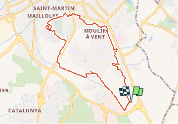

6.7 km | 7.5 km-effort


User


FREE GPS app for hiking
 SityTrail
IGN / Geographical institutes
SityTrail World
The world is yours!
Trail Walking of 10.6 km to be discovered at Occitania, Pyrénées-Orientales, Perpignan. This trail is proposed by jeff66.
66 PERPIGNAN - parking du megacastillet - mas Balande - le hameau DANTJOU - parcours le long du canal et de la voie ferrée - mas Gaffard - parc des sports - el Pontet de BAGES - av. d'Espagne - rond point des arcades - av. Nungesser et Coli - rue Louis Bleriot - rues des F.Montgolfiers, St Simon, R.Fonck, de la tuilerie, des roses, A.A. Parmentier, V.Magnan - av. Mal Juin - rues de Gascogne, du Béarn, Hortola - MAV - av. prats de Mollo, du Tech, de Lamanère, de Reynes, de montsony, d'Oms, Rambla d'occitanie, place de l'Europe, rues de Latour bas ELNE,d'ultrera, du fort Saint Elme, du pas du loup, du col de Lli, du Col de Bellegarde, de Marialles, du Pic de Capisole, du pic des 7 Hommes


Walking

Walking

Walking

Walking
Walking
Walking
Quad

Walking

Walking