Trail Touring skiing Névache - Ricou vers Gardioles - Photo
© OpenStreetMap contributors
Length
Length
3.1 km
Max alt
Max alt
2659 m
Uphill gradient
Uphill gradient
546 m
Km-Effort
Km-Effort  
8.5 km
Min alt
Min alt
2107 m
Downhill gradient
Downhill gradient
0 m
Boucle
Boucle
No
Creation date :
2016-04-08 00:00:00.0
Updated on :
2019-08-28 14:51:29.121

(0 Reviews)

Touring skiing
Touring skiing
1h56
Difficulty : Easy

Scan this QR Code to open this trail in the SityTrail application

FREE GPS app for hiking

Logo SityTrail SityTrail

IGN / Geographical institutes

Download SityTrail from the App Store Download SityTrail from Google Play

Logo SityTrail SityTrail World

The world is yours!

Download SityTrail from the App Store Download SityTrail from Google Play Download SityTrail on Huawei AppGallery

About

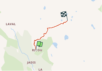
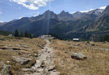
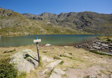
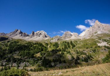
Trail Touring skiing of 3.1 km to be discovered at Provence-Alpes-Côte d'Azur, Hautes-Alpes, Névache. This trail is proposed by motardes04.

Description

Ski de rando - CAF - 3/4/2016. Temps de m*** ; pluie jusqu'à 2200 m, neige au-dessus, et surtout, du vent dès qu'on passe l'abri de la Recare. On traverse cette espèce de plaine dans un blizzard et un paysage digne du grand nord ... mais pourquoi je ne suis pas restée au lit à dorlotter mes vi-crobes ???
Avec ce vent, l'objectif du Col du Grand Cros ne paraît pas super raisonnable - ni appétissant.
Le guide - patron du Ricou qui nous a ouvert la trace un partant un peu plus tôt ce matin redescend avec son comparse. Ils confirment le peu d'intérêt de continuer. Cette fois, tout le groupe dépeaute et redescend ... une autre histoire !

Elevation profile

Positioning

Country:
France
Region :
Provence-Alpes-Côte d'Azur
Department/Province :
Hautes-Alpes
Municipality :
Névache
Location:
Unknown
Start:(UTM)
306561 ; 4991019 (32T) N.

Trails nearby

Trail Walking Névache - Briançonnais Lac du Serpent - Photo
Walking
Orcal37

Walking

Medium
(2)
Névache, Provence-Alpes-Côte d'Azur, Hautes-Alpes, France
10 km | 18 km-effort
3h 10min
Yes
Trail Walking Névache - Col du Chardonnet - Névache - Photo
Walking
tracegps

Walking

Medium
(3)
Névache, Provence-Alpes-Côte d'Azur, Hautes-Alpes, France
12.3 km | 23 km-effort
4h 0min
Yes
Trail Walking Névache - Via Alpina - R127: Névache > Le Monêtier-les-Bains - Photo
Walking
tracegps

Walking

Difficult
(1)
Névache, Provence-Alpes-Côte d'Azur, Hautes-Alpes, France
15.5 km | 28 km-effort
5h 0min
No
Trail Walking Névache - la roche du Chardonnet - Photo
Walking
GUIDE
amiral13

Walking

Medium
Névache, Provence-Alpes-Côte d'Azur, Hautes-Alpes, France
16.6 km | 29 km-effort
7h 26min
Yes
Trail Walking Névache - Lacs Laramon et Serpent - Photo
Walking
neoroll44

Walking

Medium
(2)
Névache, Provence-Alpes-Côte d'Azur, Hautes-Alpes, France
10.4 km | 21 km-effort
6h 0min
Yes
Trail Walking Névache - lacs laramon, du serpent, des gardioles et pic du lac blanc - Photo
Walking
GUIDE
amiral13

Walking

Medium
(1)
Névache, Provence-Alpes-Côte d'Azur, Hautes-Alpes, France
15.8 km | 31 km-effort
7h 30min
Yes
Trail Walking Névache - LA CLAREE: balcon de la claree - Photo
Walking
lebarbe_b@hotmail.fr

Walking

Medium
Névache, Provence-Alpes-Côte d'Azur, Hautes-Alpes, France
14.2 km | 23 km-effort
4h 7min
Yes
Trail Walking Névache - Lac Laramon - Refuge Ricou - Photo
Walking
astro45

Walking

Medium
Névache, Provence-Alpes-Côte d'Azur, Hautes-Alpes, France
3.5 km | 8.4 km-effort
1h 54min
No
Trail Walking Névache - Lac Long - Lac Rond - Refuge des Drayères - La Clarée - Photo
Walking
astro45

Walking

Very difficult
Névache, Provence-Alpes-Côte d'Azur, Hautes-Alpes, France
12.7 km | 19.3 km-effort
4h 23min
No


Close
My subscriptions