Trail Walking Escot - Pic Roumendares 1646m - Photo
 DuMarsan
DuMarsan

User

© OpenStreetMap contributors
Length
Length
10.5 km
Max alt
Max alt
1609 m
Uphill gradient
Uphill gradient
1087 m
Km-Effort
Km-Effort  
25 km
Min alt
Min alt
744 m
Downhill gradient
Downhill gradient
1057 m
Boucle
Boucle
Yes
Creation date :
2016-04-13 00:00:00.0
Updated on :
2016-04-13 00:00:00.0

(0 Reviews)

Walking
Walking
6h17
Difficulty : Medium

Scan this QR Code to open this trail in the SityTrail application

FREE GPS app for hiking

Logo SityTrail SityTrail

IGN / Geographical institutes

Download SityTrail from the App Store Download SityTrail from Google Play

Logo SityTrail SityTrail World

The world is yours!

Download SityTrail from the App Store Download SityTrail from Google Play Download SityTrail on Huawei AppGallery

About

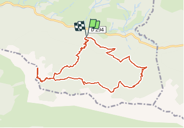
Trail Walking of 10.5 km to be discovered at New Aquitaine, Pyrénées-Atlantiques, Escot. This trail is proposed by DuMarsan.

Description

départ parking Lagangue 713 m (D 294)

Merci Christian T. pour l'idée

Elevation profile

Points of interest

Point of interest Escot - Col D'Andurte - Photo
DuMarsan
Point of interest Escot - Depart-randonnee - Photo
DuMarsan
Point of interest Escot - Pic Roumendarès - Photo
DuMarsan
Point of interest Escot - Pic Serrisse - Photo
DuMarsan

Positioning

Country:
France
Region :
New Aquitaine
Department/Province :
Pyrénées-Atlantiques
Municipality :
Escot
Location:
Unknown
Start:(UTM)
699820 ; 4771848 (30T) N.

Trails nearby

Trail On foot Sarrance - SARRANCE / ACCOUS collecte numerique GR 653 10 - Photo
On foot
GUIDE
marmotte65

On foot

Easy
Sarrance, New Aquitaine, Pyrénées-Atlantiques, France
12.7 km | 17.3 km-effort
3h 57min
No
Trail Walking Bilhères - Pic des escurets 1440m en Aller-Retour - Photo
Walking
HaschKnight

Walking

Easy
Bilhères, New Aquitaine, Pyrénées-Atlantiques, France
4.8 km | 9.9 km-effort
2h 12min
Yes
Trail On foot Escot - Tour Bilboquet-Barescou asp01 - Photo
On foot
PRO

On foot

Easy
Escot, New Aquitaine, Pyrénées-Atlantiques, France
9.9 km | 15.7 km-effort
3h 34min
Yes
Trail Walking Bilhères - BILHERES en OSSAU pic des escurets G3 - Photo
Walking
GUIDE
marmotte65

Walking

Medium
Bilhères, New Aquitaine, Pyrénées-Atlantiques, France
6 km | 11.2 km-effort
2h 3min
Yes
Trail Walking Escot - escot le bilboquet G3 fait - Photo
Walking
LouisROGER

Walking

Very easy
Escot, New Aquitaine, Pyrénées-Atlantiques, France
7.1 km | 12.5 km-effort
4h 57min
No
Trail Trail Sarrance - Col Laundé - Photo
Trail
Anteus

Trail

Easy
Sarrance, New Aquitaine, Pyrénées-Atlantiques, France
5.6 km | 10.7 km-effort
1h 12min
Yes
Trail Walking Escot - Pic Roumendarès 1646m - Photo
Walking
tracegps

Walking

Difficult
(1)
Escot, New Aquitaine, Pyrénées-Atlantiques, France
6.2 km | 17.3 km-effort
4h 15min
Yes
Trail Cycle Escot - Transpyrénéenne en cyclo - étape 3 - Escot à Luz Saint Sauveur - Photo
Cycle
tracegps

Cycle

Difficult
Escot, New Aquitaine, Pyrénées-Atlantiques, France
138 km | 197 km-effort
10h 30min
No
Trail Walking Sarrance - Chemin d'Arles à Compostelle - Sarrance - Urdos - Photo
Walking
tracegps

Walking

Difficult
Sarrance, New Aquitaine, Pyrénées-Atlantiques, France
26 km | 36 km-effort
7h 0min
No


Close
My subscriptions