Trail Walking Saint-Dié-des-Vosges - Saint-Dié - La Bure 18 400m +820m - Photo

Saint-Dié - La Bure 18 400m +820m

© OpenStreetMap contributors
Length
Length
18.4 km
Max alt
Max alt
888 m
Uphill gradient
Uphill gradient
812 m
Km-Effort
Km-Effort  
29 km
Min alt
Min alt
377 m
Downhill gradient
Downhill gradient
850 m
Boucle
Boucle
No
Creation date :
2017-09-03 00:00:00.0
Updated on :
2017-09-03 00:00:00.0

(0 Reviews)

Walking
Walking
6h02
Difficulty : Difficult

Scan this QR Code to open this trail in the SityTrail application

FREE GPS app for hiking

Logo SityTrail SityTrail

IGN / Geographical institutes

Download SityTrail from the App Store Download SityTrail from Google Play

Logo SityTrail SityTrail World

The world is yours!

Download SityTrail from the App Store Download SityTrail from Google Play Download SityTrail on Huawei AppGallery

About

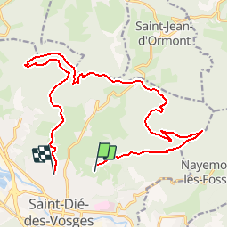
Trail Walking of 18.4 km to be discovered at Grand Est, Vosges, Saint-Dié-des-Vosges. This trail is proposed by DanielROLLET.

Description

Départ et arrivées à la gare SNCF de Saint Dié.
Nancy 7h50 > Saint-Dié 8h53
Saint Dié 16h31 > Nancy 17h48
Bus L2 jusqu'à l'arrêt Paradis à 9h38 > 9h49
Bus L1 à l'arrêt Tuilerie 16h09 > 16h19 à la gare.

Elevation profile

Positioning

Country:
France
Region :
Grand Est
Department/Province :
Vosges
Municipality :
Saint-Dié-des-Vosges
Location:
Unknown
Start:(UTM)
348854 ; 5351413 (32U) N.

Trails nearby

Trail Mountain bike Saint-Dié-des-Vosges - vtt la voivre La Bure 29-03-19 - Photo
Mountain bike
vathi54

Mountain bike

Difficult
(2)
Saint-Dié-des-Vosges, Grand Est, Vosges, France
20 km | 28 km-effort
2h 48min
Yes
Trail Walking Saint-Michel-sur-Meurthe - massif de la madeleine  - Photo
Walking
remysimon

Walking

Medium
(1)
Saint-Michel-sur-Meurthe, Grand Est, Vosges, France
14.7 km | 22 km-effort
4h 10min
Yes
Trail On foot Taintrux - GR de Pays de Déodatie - Photo
On foot
PRO

On foot

Easy
Taintrux, Grand Est, Vosges, France
7.9 km | 12.5 km-effort
2h 49min
No
Trail Walking Saint-Dié-des-Vosges - 2019-03-07 Marche Montée des Schlitteurs - Photo
Walking
GUIDE
holtzv

Walking

Very easy
Saint-Dié-des-Vosges, Grand Est, Vosges, France
11.3 km | 19.6 km-effort
4h 35min
Yes
Trail Walking Saint-Dié-des-Vosges - Massif de l'Ormont et ses rochers remarquables - Photo
Walking
Bart2015

Walking

Very difficult
Saint-Dié-des-Vosges, Grand Est, Vosges, France
15.9 km | 25 km-effort
5h 38min
Yes
Trail Walking Saint-Dié-des-Vosges - 2021-10-08 Marche St Die Metzeral Jour 1 - Photo
Walking
GUIDE
holtzv

Walking

Very difficult
Saint-Dié-des-Vosges, Grand Est, Vosges, France
26 km | 39 km-effort
7h 40min
No
Trail Walking Saint-Dié-des-Vosges - Balade autour du Col de la Crenée - Photo
Walking
Jullido1

Walking

Easy
(1)
Saint-Dié-des-Vosges, Grand Est, Vosges, France
11.4 km | 17 km-effort
3h 48min
Yes
Trail Walking Saint-Dié-des-Vosges - Marche 15km Ormont 07-05-21 - Photo
Walking
1957

Walking

Very difficult
Saint-Dié-des-Vosges, Grand Est, Vosges, France
13.5 km | 25 km-effort
4h 3min
Yes
Trail Horseback riding Ban-de-Sapt - Boucle BanDeSapt Quatre Bornes - Photo
Horseback riding
GUIDE+

Horseback riding

Medium
Ban-de-Sapt, Grand Est, Vosges, France
18.9 km | 26 km-effort
3h 13min
Yes


Close
My subscriptions