Trail Walking Itxassou - Mondarrain  par Eztebenborda  - Photo

Mondarrain par Eztebenborda

 DECHAMPD
DECHAMPD

User

© OpenStreetMap contributors
Length
Length
15.2 km
Max alt
Max alt
729 m
Uphill gradient
Uphill gradient
690 m
Km-Effort
Km-Effort  
24 km
Min alt
Min alt
342 m
Downhill gradient
Downhill gradient
664 m
Boucle
Boucle
Yes
Creation date :
2019-01-14 17:31:45.518
Updated on :
2019-01-14 17:31:45.594

(0 Reviews)

Walking
Walking
5h03
Difficulty : Medium

Scan this QR Code to open this trail in the SityTrail application

FREE GPS app for hiking

Logo SityTrail SityTrail

IGN / Geographical institutes

Download SityTrail from the App Store Download SityTrail from Google Play

Logo SityTrail SityTrail World

The world is yours!

Download SityTrail from the App Store Download SityTrail from Google Play Download SityTrail on Huawei AppGallery

About

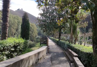
Trail Walking of 15.2 km to be discovered at New Aquitaine, Pyrénées-Atlantiques, Itxassou. This trail is proposed by DECHAMPD.

Description

effectué le 10 mai 2016
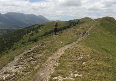
au départ du col de Légaré (350m) pour effectuer une boucle sur les hauteurs du labour en passant par l'Ezcondray, le Mondarrain, l'Ourrezti et le Mont Bizkailuze jusqu'à la ferme d'ESTEBEN
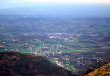
Depuis les sommets on a une vue magnifique sur la côte basque et la Rhune à l'ouest, l'Axturia, l'Alcurrunz au sud-ouest, le Gorramendi au sud, la face ouest de l'Artzamendi et le Pas de Roland au nord-est.
au sommet du Mondarrain. Une croix, sur laquelle est gravée un homme qui marche un bâton à la main, est érigée au point culminant.

Elevation profile

Points of interest

Point of interest Baztan - BF76 - Photo
DECHAMPD
BAZTAN 
Point of interest Itxassou - Point 1 - Photo
DECHAMPD
ITXASSOU 
Point of interest Itxassou - BF 77 - Photo
DECHAMPD
ITXASSOU 
Point of interest Ainhoa - GOROSPIL 658m. - Photo
DECHAMPD

Positioning

Country:
France
Region :
New Aquitaine
Department/Province :
Pyrénées-Atlantiques
Municipality :
Itxassou
Location:
Unknown
Start:(UTM)
627654 ; 4797437 (30T) N.

Trails nearby

Trail Walking Espelette - Erreka mondarain col des veaux - Photo
Walking
GUIDE
antignacs

Walking

Difficult
(1)
Espelette, New Aquitaine, Pyrénées-Atlantiques, France
18.3 km | 29 km-effort
6h 34min
Yes
Trail Walking Cambo-les-Bains - Ursuya - Cambo les Bains - Photo
Walking
tracegps

Walking

Medium
(2)
Cambo-les-Bains, New Aquitaine, Pyrénées-Atlantiques, France
9.7 km | 17.8 km-effort
2h 45min
No
Trail Walking Espelette - De la Nive à la Nivelle - Circuit des familles - Espelette - Photo
Walking
tracegps

Walking

Easy
(1)
Espelette, New Aquitaine, Pyrénées-Atlantiques, France
7.1 km | 9.2 km-effort
1h 30min
Yes
Trail Walking Espelette - ESPELETTE Le circuit des familles
Walking
GUIDE
marmotte65

Walking

Medium
Espelette, New Aquitaine, Pyrénées-Atlantiques, France
7.5 km | 9.6 km-effort
1h 55min
Yes
Trail Walking Cambo-les-Bains - CAMBO la grande boucle des thermes Appart Cambo bas-Cambo Thermes appart - Photo
Walking
GUIDE
marmotte65

Walking

Medium
Cambo-les-Bains, New Aquitaine, Pyrénées-Atlantiques, France
6 km | 7.9 km-effort
1h 23min
Yes
Trail Walking Itxassou - L'ARTZAMENDI - Photo
Walking
benat40

Walking

Easy
(1)
Itxassou, New Aquitaine, Pyrénées-Atlantiques, France
8.3 km | 18.8 km-effort
Unknown
Yes
Trail Walking Cambo-les-Bains - CAMBO la ville les thermes - Photo
Walking
GUIDE
marmotte65

Walking

Easy
Cambo-les-Bains, New Aquitaine, Pyrénées-Atlantiques, France
3.3 km | 4 km-effort
51min
No
Trail Walking Cambo-les-Bains - CAMBO terra aventura
Walking
GUIDE
marmotte65

Walking

Easy
Cambo-les-Bains, New Aquitaine, Pyrénées-Atlantiques, France
2.9 km | 4 km-effort
53min
Yes
Trail Walking Cambo-les-Bains - CAMBO la colline de la bergerie  - Photo
Walking
GUIDE
marmotte65

Walking

Easy
Cambo-les-Bains, New Aquitaine, Pyrénées-Atlantiques, France
2.6 km | 3.6 km-effort
1h 10min
Yes


Close
My subscriptions