Trail Walking Val-d'Aigoual - Favières l'Asclier, Homme mort - Photo

Favières l'Asclier, Homme mort

 mbc
mbc

User

© OpenStreetMap contributors
Length
Length
10.6 km
Max alt
Max alt
1010 m
Uphill gradient
Uphill gradient
496 m
Km-Effort
Km-Effort  
17.2 km
Min alt
Min alt
649 m
Downhill gradient
Downhill gradient
504 m
Boucle
Boucle
Yes
Signpost
Signpost
Creation date :
2016-07-25 00:00:00.0
Updated on :
2016-07-25 00:00:00.0

(0 Reviews)

Walking
Walking
3h45
Difficulty : Medium

Scan this QR Code to open this trail in the SityTrail application

FREE GPS app for hiking

Logo SityTrail SityTrail

IGN / Geographical institutes

Download SityTrail from the App Store Download SityTrail from Google Play

Logo SityTrail SityTrail World

The world is yours!

Download SityTrail from the App Store Download SityTrail from Google Play Download SityTrail on Huawei AppGallery

About

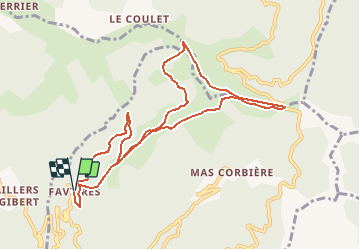
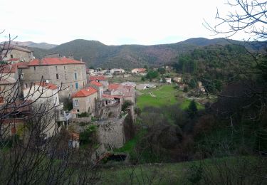
Trail Walking of 10.6 km to be discovered at Occitania, Gard, Val-d'Aigoual. This trail is proposed by mbc.

Description

A départ de Favières prendre la calade en face du gite.Rejoindre le DFCI, tournez à gauche( version douce) ou à droite (version raide) jusqu'aux 4 jasses (table de pique nique) continuez sur le Gr direction homme mort, après la jasse de Rieusset, tournez à droite vers le col de l'Asclier.En arrivant sur la grande draille, descendre jusqu'au pont moutonnier, (pensez à saluer le berger)
table et source en descendant la  50 m
Rependre la draile GR 67 vers le col de lhomme mort, puis rejoindre Favières en passant dans la forêt de hêtres

Elevation profile

Positioning

Country:
France
Region :
Occitania
Department/Province :
Gard
Municipality :
Val-d'Aigoual
Location:
Notre-Dame-de-la-Rouvière
Start:(UTM)
556726 ; 4879573 (31T) N.

Trails nearby

Trail Walking Les Plantiers - Vallée Borgne - Photo
Walking
GUIDE
nadinebondoux

Walking

Difficult
Les Plantiers, Occitania, Gard, France
19.7 km | 32 km-effort
5h 19min
Yes
Trail Walking Les Plantiers - Sentier du Mouflon - Les Plantiers  - Photo
Walking
GUIDE
randotines

Walking

Difficult
Les Plantiers, Occitania, Gard, France
11.2 km | 18.6 km-effort
3h 30min
Yes
Trail Walking Saint-Martial - Montagne du Liron au départ de St Martial - Photo
Walking
GUIDE
nadinebondoux

Walking

Difficult
Saint-Martial, Occitania, Gard, France
19.4 km | 32 km-effort
7h 4min
Yes
Trail Walking Saint-Martial - arsel saint martial  - Photo
Walking
labarone

Walking

Medium
Saint-Martial, Occitania, Gard, France
22 km | 34 km-effort
7h 32min
Yes
Trail Walking Saint-Martial - Le col de la Tribale Le col de Bez Saint Martial  - Photo
Walking
boudpn

Walking

(1)
Saint-Martial, Occitania, Gard, France
10.7 km | 15.7 km-effort
5h 22min
Yes
Trail Walking Val-d'Aigoual - Col d’asclier rocher de l’aigle  - Photo
Walking
GUIDE
antignacs

Walking

Very difficult
Val-d'Aigoual, Occitania, Gard, France
20 km | 30 km-effort
6h 10min
Yes
Trail Hybrid bike Saint-Martial - Saint martial valleraurgues - Photo
Hybrid bike
GUIDE
antignacs

Hybrid bike

Difficult
Saint-Martial, Occitania, Gard, France
57 km | 72 km-effort
6h 5min
Yes
Trail Walking Saint-Martial - Saint martial 3 cols - Photo
Walking
GUIDE
antignacs

Walking

Difficult
Saint-Martial, Occitania, Gard, France
18.1 km | 27 km-effort
6h 10min
Yes
Trail Walking Saint-André-de-Majencoules - les grandes collines à partir de St André de majencoules - Photo
Walking
labarone

Walking

Medium
Saint-André-de-Majencoules, Occitania, Gard, France
21 km | 35 km-effort
6h 36min
Yes


Close
My subscriptions