![](/images/other/stat-length.png)
![Trail Walking Vielle-Aure - soum de montelat - Photo](https://media.geolcdn.com/t/1900/400/ext.pjpeg?maxdim=2&url=https%3A%2F%2Fstatic1.geolcdn.com%2Fsiteimages%2Fupload%2Ffiles%2F1553511878bg_sport_marche.png)
soum de montelat
dawed311
User
![Length](/images/other/stat-length.png)
Length
17.3 km
![Max alt](https://static1.geolcdn.com/siteimages/upload/files/1508320355ic_sort_altitude_max_24dp.png)
Max alt
2512 m
![Uphill gradient](https://static1.geolcdn.com/siteimages/upload/files/1508320355ic_sort_den_pos_24dp.png)
Uphill gradient
867 m
![Km-Effort](/images/other/stat-length.png)
Km-Effort
29 km
![Min alt](https://static1.geolcdn.com/siteimages/upload/files/1508320355ic_sort_altitude_min_24dp.png)
Min alt
2118 m
![Downhill gradient](https://static1.geolcdn.com/siteimages/upload/files/1508320355ic_sort_den_neg_24dp.png)
Downhill gradient
877 m
![Boucle](https://static1.geolcdn.com/siteimages/upload/files/16400158638029165_repeat_loop_refresh_sync_direction_icon.png)
Boucle
Yes
Creation date :
2019-05-09 20:38:59.293
Updated on :
2020-02-17 20:46:21.555
![Walking](https://static1.geolcdn.com/sitytour/trail-icons/101.png)
5h46
Difficulty : Easy
![Scan this QR Code to open this trail in the SityTrail application](https://capi.geolives.com/qq0zvz2zws4bq2lad0pu/sitytour/trails/652709/qr.png?size=200)
FREE GPS app for hiking
About
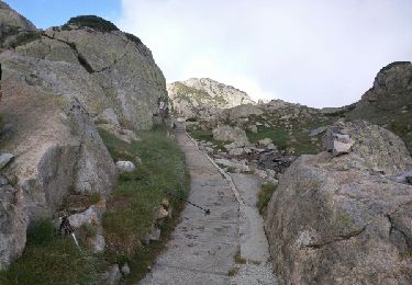
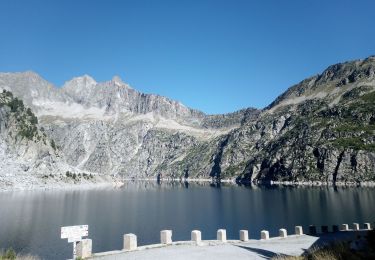
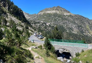
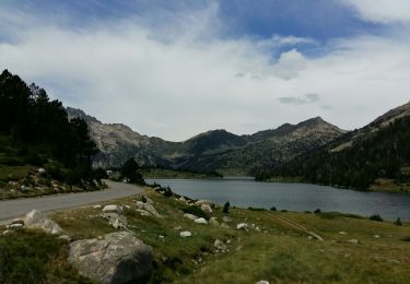
Trail Walking of 17.3 km to be discovered at Occitania, Hautespyrenees, Vielle-Aure. This trail is proposed by dawed311.
Description
La montée sur le GR10 au Soum de Monpelat est facile mais offre une très jolie vue sur le Néouvielle et ses voisins, ainsi que sur les Lacs. Une petite montée au col de Madamète pour se remettre en forme et avoir un autre angle de vue.
Positioning
Country:
France
Region :
Occitania
Department/Province :
Hautespyrenees
Municipality :
Vielle-Aure
Location:
Unknown
Start:(Dec)
Start:(UTM)
266641 ; 4747031 (31T) N.
Comments
Trails nearby
![Trail Walking Barèges - Refuge de Glère brèche de Chaussenque Pic de Neouvielle, lac d'Oredon - Photo](https://media.geolcdn.com/t/375/260/ext.jpg?maxdim=2&url=https%3A%2F%2Fservices.sitytrail.com%2FGeolivesWS%2FDownloadMedia.ashx%3FTrailID%3D618683%26Media%3Dfix__20160810093955.jpg)
![Walking Walking](https://static1.geolcdn.com/sitytour/trail-icons/101.png)
Refuge de Glère brèche de Chaussenque Pic de Neouvielle, lac d'Oredon
Walking
Difficult
(1)
Barèges,
Occitania,
Hautespyrenees,
France
![](/images/other/stat-length.png)
16.2 km | 31 km-effort
5h 58min
![](https://static1.geolcdn.com/siteimages/upload/files/16400158638029165_repeat_loop_refresh_sync_direction_icon.png)
No
![Trail Walking Barèges - Pic des Trois Conseillers - Photo](https://media.geolcdn.com/t/375/260/ext.jpg?maxdim=2&url=https%3A%2F%2Fservices.sitytrail.com%2FGeolivesWS%2FDownloadMedia.ashx%3FTrailID%3D172698%26Media%3D14081_6.jpg)
![Walking Walking](https://static1.geolcdn.com/sitytour/trail-icons/101.png)
Pic des Trois Conseillers
Walking
Very difficult
(1)
Barèges,
Occitania,
Hautespyrenees,
France
![](/images/other/stat-length.png)
16 km | 34 km-effort
9h 0min
![](https://static1.geolcdn.com/siteimages/upload/files/16400158638029165_repeat_loop_refresh_sync_direction_icon.png)
Yes
![Trail Walking Aragnouet - Pic d'Estaragne et Pic Cambieil - Photo](https://media.geolcdn.com/t/375/260/ext.jpg?maxdim=2&url=https%3A%2F%2Fservices.sitytrail.com%2FGeolivesWS%2FDownloadMedia.ashx%3FTrailID%3D108155%26Media%3D319_6.jpg)
![Walking Walking](https://static1.geolcdn.com/sitytour/trail-icons/101.png)
Pic d'Estaragne et Pic Cambieil
Walking
Very difficult
(2)
Aragnouet,
Occitania,
Hautespyrenees,
France
![](/images/other/stat-length.png)
11.6 km | 28 km-effort
3h 40min
![](https://static1.geolcdn.com/siteimages/upload/files/16400158638029165_repeat_loop_refresh_sync_direction_icon.png)
Yes
![Trail Walking Saint-Lary-Soulan - Le soum de Monpelat par les laquettes (Néouvielle) - Photo](https://media.geolcdn.com/t/375/260/ext.jpg?maxdim=2&url=https%3A%2F%2Fservices.sitytrail.com%2FGeolivesWS%2FDownloadMedia.ashx%3FTrailID%3D108150%26Media%3D252_6.jpg)
![Walking Walking](https://static1.geolcdn.com/sitytour/trail-icons/101.png)
Le soum de Monpelat par les laquettes (Néouvielle)
Walking
Difficult
(2)
Saint-Lary-Soulan,
Occitania,
Hautespyrenees,
France
![](/images/other/stat-length.png)
11.5 km | 21 km-effort
3h 10min
![](https://static1.geolcdn.com/siteimages/upload/files/16400158638029165_repeat_loop_refresh_sync_direction_icon.png)
Yes
![Trail Walking Saint-Lary-Soulan - Lac d''Oredon - lac d''Aubert - Photo](https://media.geolcdn.com/t/375/260/ext.jpg?maxdim=2&url=https%3A%2F%2Fservices.sitytrail.com%2FGeolivesWS%2FDownloadMedia.ashx%3FTrailID%3D40898%26Media%3Dimage3.jpg)
![Walking Walking](https://static1.geolcdn.com/sitytour/trail-icons/101.png)
Lac d''Oredon - lac d''Aubert
Walking
Very easy
(1)
Saint-Lary-Soulan,
Occitania,
Hautespyrenees,
France
![](/images/other/stat-length.png)
4.2 km | 7.4 km-effort
Unknown
![](https://static1.geolcdn.com/siteimages/upload/files/16400158638029165_repeat_loop_refresh_sync_direction_icon.png)
No
![Trail Walking Aragnouet - 2023-09-08 Lacs Neouvielle - Photo](https://media.geolcdn.com/t/375/260/ext.jpg?maxdim=2&url=https%3A%2F%2Fmedia.geolcdn.com%2Ff%2Fa59ce9de-5eea-442c-b992-1dd4a2a4e647.jpg)
![Walking Walking](https://static1.geolcdn.com/sitytour/trail-icons/101.png)
2023-09-08 Lacs Neouvielle
Walking
Difficult
Aragnouet,
Occitania,
Hautespyrenees,
France
![](/images/other/stat-length.png)
13.9 km | 24 km-effort
5h 55min
![](https://static1.geolcdn.com/siteimages/upload/files/16400158638029165_repeat_loop_refresh_sync_direction_icon.png)
Yes
![Trail Walking Aragnouet - Col et pic d’Estaragne - Photo](https://media.geolcdn.com/t/375/260/ext.jpg?maxdim=2&url=https%3A%2F%2Fmedia.geolcdn.com%2Ff%2F576c4a70-5052-460c-a6b9-4bdb7cddbb86.jpg)
![Walking Walking](https://static1.geolcdn.com/sitytour/trail-icons/101.png)
Col et pic d’Estaragne
Walking
Very difficult
Aragnouet,
Occitania,
Hautespyrenees,
France
![](/images/other/stat-length.png)
9.5 km | 24 km-effort
3h 25min
![](https://static1.geolcdn.com/siteimages/upload/files/16400158638029165_repeat_loop_refresh_sync_direction_icon.png)
Yes
![Trail Walking Saint-Lary-Soulan - malamete-lac-nere-hourquette-d'aubert-depuis-oredon - Photo](https://media.geolcdn.com/t/375/260/ext.jpg?maxdim=2&url=https%3A%2F%2Fmedia.geolcdn.com%2Ff%2F5fd65d2f-6441-4fce-902b-3dfeaf32f91e.jpg)
![Walking Walking](https://static1.geolcdn.com/sitytour/trail-icons/101.png)
malamete-lac-nere-hourquette-d'aubert-depuis-oredon
Walking
Very difficult
Saint-Lary-Soulan,
Occitania,
Hautespyrenees,
France
![](/images/other/stat-length.png)
21 km | 36 km-effort
6h 28min
![](https://static1.geolcdn.com/siteimages/upload/files/16400158638029165_repeat_loop_refresh_sync_direction_icon.png)
Yes
![Trail Walking Saint-Lary-Soulan - FABIAN / ARAGNOUET les lac du neouvielle G3](https://media.geolcdn.com/t/375/260/ext.jpg?maxdim=2&url=https%3A%2F%2Fmedia.geolcdn.com%2Ff%2Fa45fef57-be9c-4b1d-914d-8ba554c6b6eb.jpg)
![Walking Walking](https://static1.geolcdn.com/sitytour/trail-icons/101.png)
FABIAN / ARAGNOUET les lac du neouvielle G3 "3325574"
Walking
Difficult
Saint-Lary-Soulan,
Occitania,
Hautespyrenees,
France
![](/images/other/stat-length.png)
9.1 km | 14 km-effort
5h 47min
![](https://static1.geolcdn.com/siteimages/upload/files/16400158638029165_repeat_loop_refresh_sync_direction_icon.png)
Yes