Trail Walking Saint-Leu-d'Esserent - CRAB : Saint Leu d'Esserent - Photo

CRAB : Saint Leu d'Esserent

 PatRando
PatRando

User

© OpenStreetMap contributors
Length
Length
24 km
Max alt
Max alt
140 m
Uphill gradient
Uphill gradient
365 m
Km-Effort
Km-Effort  
28 km
Min alt
Min alt
28 m
Downhill gradient
Downhill gradient
366 m
Boucle
Boucle
Yes
Creation date :
2016-12-17 00:00:00.0
Updated on :
2016-12-17 00:00:00.0

(0 Reviews)

Walking
Walking
6h07
Difficulty : Easy

Scan this QR Code to open this trail in the SityTrail application

FREE GPS app for hiking

Logo SityTrail SityTrail

IGN / Geographical institutes

Download SityTrail from the App Store Download SityTrail from Google Play

Logo SityTrail SityTrail World

The world is yours!

Download SityTrail from the App Store Download SityTrail from Google Play Download SityTrail on Huawei AppGallery

About

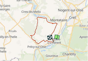
Trail Walking of 24 km to be discovered at Hauts-de-France, Oise, Saint-Leu-d'Esserent. This trail is proposed by PatRando.

Description

6 Novembre 2016
Un tour en nacelle

Elevation profile

Photos

Positioning

Country:
France
Region :
Hauts-de-France
Department/Province :
Oise
Municipality :
Saint-Leu-d'Esserent
Location:
Unknown
Start:(UTM)
457708 ; 5451450 (31U) N.

Trails nearby

Trail Walking Boran-sur-Oise - randonnée abbaye de Royaumont - Photo
Walking
jumetz philippe

Walking

Difficult
(1)
Boran-sur-Oise, Hauts-de-France, Oise, France
13.2 km | 14.5 km-effort
3h 8min
Yes
Trail Mountain bike Montataire - Rando des Forges 2012 - Montataire - Photo
Mountain bike
tracegps

Mountain bike

Medium
(1)
Montataire, Hauts-de-France, Oise, France
43 km | 51 km-effort
2h 30min
Yes
Trail Walking Chantilly - chantilly Gouvieux - Photo
Walking
Jacques Salfati

Walking

Easy
Chantilly, Hauts-de-France, Oise, France
20 km | 0 m-effort
5h 59min
Yes
Trail Walking Précy-sur-Oise - randonnée de precy au bois st Michel - Photo
Walking
jumetz philippe

Walking

Medium
Précy-sur-Oise, Hauts-de-France, Oise, France
11.6 km | 14.2 km-effort
2h 47min
Yes
Trail Walking Villers-sous-Saint-Leu - THIVERNY_12,6 km_Trace GPS - Photo
Walking
Pousscailleux

Walking

Medium
Villers-sous-Saint-Leu, Hauts-de-France, Oise, France
12.6 km | 14.7 km-effort
2h 56min
Yes
Trail Walking Villers-sous-Saint-Leu - La Rive des Moines - 9,6 km - Photo
Walking
Pousscailleux

Walking

Easy
(1)
Villers-sous-Saint-Leu, Hauts-de-France, Oise, France
9.6 km | 11.3 km-effort
1h 58min
Yes
Trail Mountain bike Chantilly - Dans la forêt de Chantilly - Photo
Mountain bike
tracegps

Mountain bike

Medium
Chantilly, Hauts-de-France, Oise, France
19.7 km | 22 km-effort
1h 30min
Yes
Trail Walking Chantilly - Dans la forêt de Chantilly - Photo
Walking
tracegps

Walking

Medium
Chantilly, Hauts-de-France, Oise, France
19.7 km | 22 km-effort
5h 0min
Yes
Trail Walking Précy-sur-Oise - les maisons troglodytes - Photo
Walking
jumetz philippe

Walking

Medium
Précy-sur-Oise, Hauts-de-France, Oise, France
11.6 km | 13.2 km-effort
2h 33min
Yes


Close
My subscriptions