Trail Walking Montmoreau - Aignes Saint-Amant - Photo
 dorcier
dorcier

User

© OpenStreetMap contributors
Length
Length
8.6 km
Max alt
Max alt
176 m
Uphill gradient
Uphill gradient
182 m
Km-Effort
Km-Effort  
11 km
Min alt
Min alt
85 m
Downhill gradient
Downhill gradient
182 m
Boucle
Boucle
Yes
Creation date :
2016-11-18 00:00:00.0
Updated on :
2016-11-18 00:00:00.0

(0 Reviews)

Walking
Walking
2h22
Difficulty : Easy

Scan this QR Code to open this trail in the SityTrail application

FREE GPS app for hiking

Logo SityTrail SityTrail

IGN / Geographical institutes

Download SityTrail from the App Store Download SityTrail from Google Play

Logo SityTrail SityTrail World

The world is yours!

Download SityTrail from the App Store Download SityTrail from Google Play Download SityTrail on Huawei AppGallery

About

Trail Walking of 8.6 km to be discovered at New Aquitaine, Charente, Montmoreau. This trail is proposed by dorcier.

Description

circuit agréable que l'on peut faire au départ du Maine Boucherie ou de Saint Hilaire.
Parcours boisé.
Non balisé.

Elevation profile

Positioning

Country:
France
Region :
New Aquitaine
Department/Province :
Charente
Municipality :
Montmoreau
Location:
Unknown
Start:(UTM)
277218 ; 5034135 (31T) N.

Trails nearby

Trail Walking Montmoreau - la maison du loup Gurat 27/02/2021 3H - Photo
Walking
dorcier

Walking

Medium
(1)
Montmoreau, New Aquitaine, Charente, France
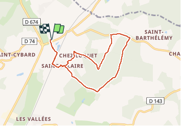
11 km | 13.6 km-effort
3h 5min
Yes
Trail On foot Montmoreau - St Laurent/ StAmant - Photo
On foot
dorcier

On foot

Medium
Montmoreau, New Aquitaine, Charente, France
8.4 km | 10.7 km-effort
2h 20min
Yes
Trail Walking Montmoreau - St Amant de Montmoreau  13,5 - Photo
Walking
phil24

Walking

Medium
(1)
Montmoreau, New Aquitaine, Charente, France
13.5 km | 18.1 km-effort
3h 0min
Yes
Trail Walking Boisné-la-Tude - Chavenat - Photo
Walking
dorcier

Walking

Easy
Boisné-la-Tude, New Aquitaine, Charente, France
8.1 km | 10.3 km-effort
2h 13min
Yes
Trail Walking Montmoreau - st amant galette - Photo
Walking
dorcier

Walking

Very easy
Montmoreau, New Aquitaine, Charente, France
8.4 km | 10.4 km-effort
2h 32min
Yes
Trail Walking Montmoreau - Saint-Eutrope (le Pinier, Chez Guillochoux, La Forêt) - Photo
Walking
dorcier

Walking

Medium
Montmoreau, New Aquitaine, Charente, France
8.9 km | 11.4 km-effort
2h 27min
Yes
Trail Walking Boisné-la-Tude - CHAVENAT - Photo
Walking
dorcier

Walking

Easy
Boisné-la-Tude, New Aquitaine, Charente, France
10.1 km | 12.7 km-effort
2h 50min
Yes
Trail Walking Montmoreau - Rando AJM - Photo
Walking
dorcier

Walking

Montmoreau, New Aquitaine, Charente, France
6.7 km | 8.3 km-effort
1h 37min
Yes
Trail Walking Montmoreau - Montmoreau  - Photo
Walking
dorcier

Walking

Very easy
Montmoreau, New Aquitaine, Charente, France
5.1 km | 6.3 km-effort
1h 13min
Yes


Close
My subscriptions