Trail Other activity Saint-Lô - Basse Normandie - Ligne 414 - Saint-Lô - Guilberville - Photo

Basse Normandie - Ligne 414 - Saint-Lô - Guilberville

 mich54
mich54

User

© OpenStreetMap contributors
Length
Length
25 km
Max alt
Max alt
223 m
Uphill gradient
Uphill gradient
344 m
Km-Effort
Km-Effort  
29 km
Min alt
Min alt
12 m
Downhill gradient
Downhill gradient
138 m
Boucle
Boucle
No
Creation date :
2017-01-25 00:00:00.0
Updated on :
2017-01-25 00:00:00.0

(0 Reviews)

Other activity
Other activity
5m
Difficulty : Unknown

Scan this QR Code to open this trail in the SityTrail application

FREE GPS app for hiking

Logo SityTrail SityTrail

IGN / Geographical institutes

Download SityTrail from the App Store Download SityTrail from Google Play

Logo SityTrail SityTrail World

The world is yours!

Download SityTrail from the App Store Download SityTrail from Google Play Download SityTrail on Huawei AppGallery

About

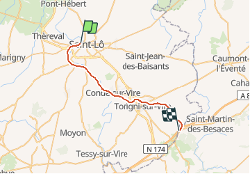
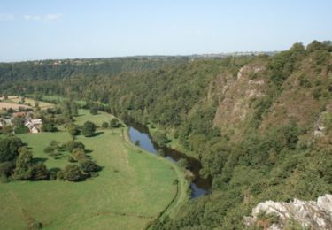
Trail Other activity of 25 km to be discovered at Normandy, Manche, Saint-Lô. This trail is proposed by mich54.

Description

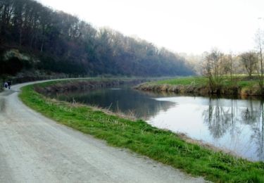
La ligne de Saint-Lô à Guilberville est une ancienne ligne du réseau ferré français ouverte en 1892.
Desserte actuelle
Une des quinze cyclo-draisines du vélorail de Condé-sur-Vire (Association Pour la Vire).
La voie ferrée n'est plus utilisable par la SNCF depuis Saint-Lô car ses rails ont été déposés de Saint-Lô au lieu-dit Candol.
Le tronçon Condé-sur-Vire-Gourfaleur (5,5 km) est exploité pour l'usage touristique par une association 7 pour la circulation touristique de quinze Vélorails..(Source Wikipédia)

Elevation profile

Positioning

Country:
France
Region :
Normandy
Department/Province :
Manche
Municipality :
Saint-Lô
Location:
Unknown
Start:(UTM)
638630 ; 5442179 (30U) N.

Trails nearby

Trail Walking Saint-Gilles - St Gilles Château de Canisy - Photo
Walking
guy50880

Walking

Very easy
Saint-Gilles, Normandy, Manche, France
9 km | 10.7 km-effort
2h 26min
Yes
Trail Mountain bike Agneaux - L'Agnelaise 2014 - Agneaux - Photo
Mountain bike
tracegps

Mountain bike

Difficult
Agneaux, Normandy, Manche, France
44 km | 52 km-effort
3h 0min
Yes
Trail Walking Saint-Lô - Saint-Lô - La Vire et le Falaise - Photo
Walking
PatRando

Walking

Easy
Saint-Lô, Normandy, Manche, France
5.4 km | 6.6 km-effort
1h 20min
Yes
Trail Walking Saint-Lô - BALLADE 2 JUIN - Photo
Walking
PatRando

Walking

Very easy
Saint-Lô, Normandy, Manche, France
3.1 km | 3.7 km-effort
51min
Yes
Trail Walking Saint-Lô - Ballade 2 juin 2020 - Photo
Walking
PatRando

Walking

Very easy
Saint-Lô, Normandy, Manche, France
3.6 km | 4.2 km-effort
1h 2min
Yes
Trail Walking Saint-Lô - Ballade - Photo
Walking
PatRando

Walking

Very easy
Saint-Lô, Normandy, Manche, France
814 m | 940 m-effort
22min
Yes
Trail Walking Saint-Lô - Le Hutrel 27 ai 2020 - Photo
Walking
PatRando

Walking

Very easy
Saint-Lô, Normandy, Manche, France
2.3 km | 2.9 km-effort
48min
Yes
Trail Mountain bike Saint-Lô - Au pied des remparts de Saint-Lô - Photo
Mountain bike
tracegps

Mountain bike

Medium
Saint-Lô, Normandy, Manche, France
18.2 km | 23 km-effort
2h 0min
Yes
Trail Mountain bike Saint-Lô - Les Roches du Ham - Saint Lo - Photo
Mountain bike
tracegps

Mountain bike

Difficult
Saint-Lô, Normandy, Manche, France
31 km | 37 km-effort
2h 0min
Yes


Close
My subscriptions