Trail Walking Vallières-sur-Fier - Versonnex-Sion - Photo
 HERRY
HERRY

User GUIDE

© OpenStreetMap contributors
Length
Length
9.8 km
Max alt
Max alt
525 m
Uphill gradient
Uphill gradient
257 m
Km-Effort
Km-Effort  
13.3 km
Min alt
Min alt
326 m
Downhill gradient
Downhill gradient
257 m
Boucle
Boucle
Yes
Creation date :
2017-02-27 00:00:00.0
Updated on :
2017-02-27 00:00:00.0

(0 Reviews)

Walking
Walking
2h16
Difficulty : Medium

Scan this QR Code to open this trail in the SityTrail application

FREE GPS app for hiking

Logo SityTrail SityTrail

IGN / Geographical institutes

Download SityTrail from the App Store Download SityTrail from Google Play

Logo SityTrail SityTrail World

The world is yours!

Download SityTrail from the App Store Download SityTrail from Google Play Download SityTrail on Huawei AppGallery

About

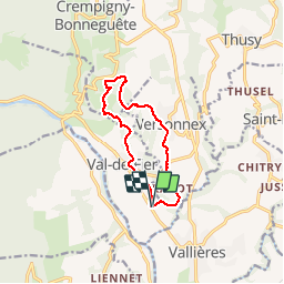
Trail Walking of 9.8 km to be discovered at Auvergne-Rhône-Alpes, Upper Savoy, Vallières-sur-Fier. This trail is proposed by HERRY.

Description

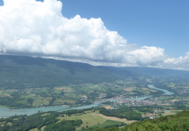
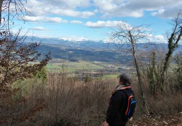
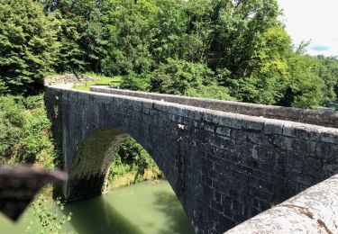
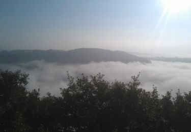
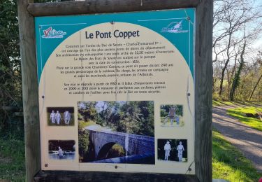
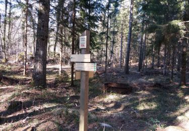
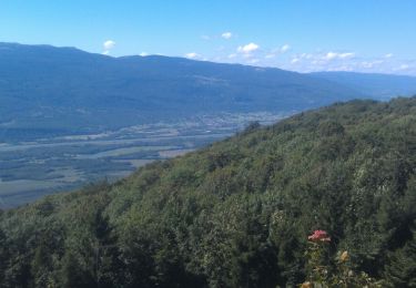
Circuit à travers la campagne de l'Albanais.Un peu long pour des enfants de moins de 10 ans. Il permet de visualiser le parcours du fier sur un coteau bien exposé au sud. Autrefois le vignoble était présent sur ces terrains orientés sud.Le départ peut se faire à Versonnex ( place de l'église) ou comme je l'ai fait à l'arrêt de bus scolaire sur la ligne droite du val de fier. Attention ce circuit n'a pas de balisage hormis de temps en temps une signalétique VTT sur un circuit qui ne suit pas le nôtre.Si vous partez de Versonnex, prendre la direction "Chez Jacquet ", descendre la route puis au point 2 suivre le chemin de Montpelly.Vous arrivez plus haut à la ferme Crête que vous contournez par la droite. Vous allez trouver un balisage VTT qu'il faut suivre à travers le bois de Folliet (point 3). Continuer jusqu'au point 4 où vous laisserez le balisage VTT qui monte sur la droite. Descendez sur votre gauche vers le hameau de Bévy. Un peu avant les maisons tourner sur votre gauche (point 5). Attention pas de balisage ici.Vous allez cheminer vers le hameau de St-sauveur que vous laissez sur votre gauche puis continuez vers Sion jusqu'au Point 6 où vous prendrez un raccourci pour rejoindre la promenade de Gerbaz. Pour rejoindre Versonnex continuez sur cette promenade qui vous amène au hameau de Piracot.Vous suivrez un peu de route puis traversez la D44 au point 8 pour rejoindre Versonnex par un chemin de terre qui monte bien.

Elevation profile

Points of interest

Point of interest Versonnex - POINT_1 - Photo
HERRY
VERSONNEX 
Point of interest Versonnex - Point_2 - Photo
HERRY
VERSONNEX 
Point of interest Versonnex - Point_3 - Photo
HERRY
VERSONNEX 
Point of interest Crempigny-Bonneguête - Point_4 - Photo
HERRY
CREMPIGNY-BONNEGUÊTE 
Point of interest Crempigny-Bonneguête - Point_5 - Photo
HERRY
CREMPIGNY-BONNEGUÊTE 
Point of interest Vallières-sur-Fier - Point_6 - Photo
HERRY
VALLIÈRES-SUR-FIER 
Point of interest Vallières-sur-Fier - Point_7 - Photo
HERRY
VALLIÈRES-SUR-FIER 
Point of interest Versonnex - Point_8 - Photo
HERRY
VERSONNEX 

Positioning

Country:
France
Region :
Auvergne-Rhône-Alpes
Department/Province :
Upper Savoy
Municipality :
Vallières-sur-Fier
Location:
Val-de-Fier
Start:(UTM)
726561 ; 5088248 (31T) N.

Trails nearby

Trail Walking Vallières-sur-Fier - VAL_DE_FIER_BALCONS - Photo
Walking
GUIDE
HERRY

Walking

Very easy
(1)
Vallières-sur-Fier, Auvergne-Rhône-Alpes, Upper Savoy, France
8.4 km | 15.1 km-effort
2h 49min
Yes
Trail Walking Lornay - LE GROS FOUG: LORNAY - Photo
Walking
djeepee74

Walking

Medium
(1)
Lornay, Auvergne-Rhône-Alpes, Upper Savoy, France
9.1 km | 15.7 km-effort
3h 0min
Yes
Trail Walking Sales - Pont Coppet - Photo
Walking
GUIDE
HERRY

Walking

Sales, Auvergne-Rhône-Alpes, Upper Savoy, France
8.6 km | 10.2 km-effort
1h 53min
Yes
Trail Mountain bike Moye - 74- Le Gros Foug - Photo
Mountain bike
cavpsy74

Mountain bike

Difficult
(1)
Moye, Auvergne-Rhône-Alpes, Upper Savoy, France
21 km | 35 km-effort
4h 0min
Yes
Trail Walking Lornay - TOUR_DE_LORNAY - Photo
Walking
GUIDE
HERRY

Walking

Very easy
Lornay, Auvergne-Rhône-Alpes, Upper Savoy, France
5.5 km | 8.6 km-effort
1h 57min
Yes
Trail Nordic walking Vallières-sur-Fier - Val de Fier - Croix saint-André - Photo
Nordic walking
woody85

Nordic walking

Difficult
Vallières-sur-Fier, Auvergne-Rhône-Alpes, Upper Savoy, France
5.6 km | 10.4 km-effort
1h 21min
Yes
Trail Walking Vallières-sur-Fier - VALLIERES 3 - Photo
Walking
Jean-Paulchoux

Walking

Medium
Vallières-sur-Fier, Auvergne-Rhône-Alpes, Upper Savoy, France
16 km | 19 km-effort
4h 43min
Yes
Trail Walking Moye - CLERGEON: VESTIGES CAMP 3 - MONTCLERGEON - Photo
Walking
djeepee74

Walking

Medium
Moye, Auvergne-Rhône-Alpes, Upper Savoy, France
11.4 km | 16.7 km-effort
3h 45min
Yes
Trail Nordic walking Moye - Foret du Clergeon - Photo
Nordic walking
woody85

Nordic walking

Medium
Moye, Auvergne-Rhône-Alpes, Upper Savoy, France
10.8 km | 16.7 km-effort
2h 25min
Yes


Close
My subscriptions