Trail Mountain bike Mont-Louis - train jaune - Photo
© OpenStreetMap contributors
Length
Length
26 km
Max alt
Max alt
1995 m
Uphill gradient
Uphill gradient
607 m
Km-Effort
Km-Effort  
37 km
Min alt
Min alt
623 m
Downhill gradient
Downhill gradient
1552 m
Boucle
Boucle
No
Creation date :
2019-05-02 13:43:11.944
Updated on :
2019-05-02 13:43:12.075

(0 Reviews)

Mountain bike
Mountain bike
2h11
Difficulty : Difficult

Scan this QR Code to open this trail in the SityTrail application

FREE GPS app for hiking

Logo SityTrail SityTrail

IGN / Geographical institutes

Download SityTrail from the App Store Download SityTrail from Google Play

Logo SityTrail SityTrail World

The world is yours!

Download SityTrail from the App Store Download SityTrail from Google Play Download SityTrail on Huawei AppGallery

About

Trail Mountain bike of 26 km to be discovered at Occitania, Pyrénées-Orientales, Mont-Louis. This trail is proposed by bruno.balayer.

Description

la rando du train jaune superbe mais réservée à des vététistes avertis : passage cailloux et épingles pas évident.

Elevation profile

Positioning

Country:
France
Region :
Occitania
Department/Province :
Pyrénées-Orientales
Municipality :
Mont-Louis
Location:
Unknown
Start:(UTM)
428017 ; 4706553 (31T) N.

Trails nearby

Trail Walking Eyne - Eyne,col de Nuria,pic d'Eyne,Torre d'Eyne,Eyne. - Photo
Walking
Machaon6

Walking

Very difficult
(1)
Eyne, Occitania, Pyrénées-Orientales, France
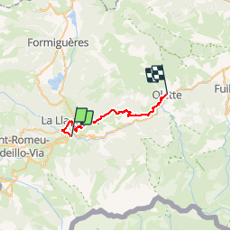
24 km | 43 km-effort
8h 44min
Yes
Trail Walking Fontpédrouse - Tour du Cucurucull - Photo
Walking
Pek56

Walking

Medium
(1)
Fontpédrouse, Occitania, Pyrénées-Orientales, France
9.3 km | 18.5 km-effort
3h 24min
Yes
Trail Walking Planès - étang de Planès - Photo
Walking
fhascoet

Walking

Medium
(2)
Planès, Occitania, Pyrénées-Orientales, France
10.8 km | 19.6 km-effort
3h 54min
No
Trail Walking Fontpédrouse - fontpérouse sentier des canaux et sources chaudes naturelles_T - Photo
Walking
force

Walking

Medium
(1)
Fontpédrouse, Occitania, Pyrénées-Orientales, France
13.7 km | 25 km-effort
5h 9min
Yes
Trail Walking Eyne - Le Cambre d'Ase - Photo
Walking
tracegps

Walking

Difficult
(1)
Eyne, Occitania, Pyrénées-Orientales, France
8.9 km | 22 km-effort
4h 0min
Yes
Trail Walking Eyne - Vallée d'Eyne - Photo
Walking
GUIDE
nadinebondoux

Walking

Medium
Eyne, Occitania, Pyrénées-Orientales, France
10.7 km | 17.6 km-effort
4h 40min
Yes
Trail Walking Bolquère - bolqueres - Photo
Walking
foxtay

Walking

Very easy
(1)
Bolquère, Occitania, Pyrénées-Orientales, France
3.8 km | 4.6 km-effort
1h 1min
Yes
Trail Walking La Cabanasse - Mois pontpedrouse après montée en train jaune  - Photo
Walking
GUIDE
stef789

Walking

Very easy
La Cabanasse, Occitania, Pyrénées-Orientales, France
9.2 km | 14.3 km-effort
3h 33min
No
Trail Walking Saint-Pierre-dels-Forcats - bains  de St Thomas  - Photo
Walking
Ptitjack30

Walking

Medium
(1)
Saint-Pierre-dels-Forcats, Occitania, Pyrénées-Orientales, France
8.6 km | 12.2 km-effort
2h 42min
No


Close
My subscriptions