Trail Mountain bike Bouxwiller - Au départ de Bouxwiller - Photo

Au départ de Bouxwiller

 raydiez
raydiez

User

© OpenStreetMap contributors
Length
Length
26 km
Max alt
Max alt
397 m
Uphill gradient
Uphill gradient
568 m
Km-Effort
Km-Effort  
33 km
Min alt
Min alt
177 m
Downhill gradient
Downhill gradient
573 m
Boucle
Boucle
Yes
Creation date :
2017-08-06 00:00:00.0
Updated on :
2017-08-06 00:00:00.0

(0 Reviews)

Mountain bike
Mountain bike
--
Difficulty : Easy

Scan this QR Code to open this trail in the SityTrail application

FREE GPS app for hiking

Logo SityTrail SityTrail

IGN / Geographical institutes

Download SityTrail from the App Store Download SityTrail from Google Play

Logo SityTrail SityTrail World

The world is yours!

Download SityTrail from the App Store Download SityTrail from Google Play Download SityTrail on Huawei AppGallery

About

Trail Mountain bike of 26 km to be discovered at Grand Est, Bas-Rhin, Bouxwiller. This trail is proposed by raydiez.

Description

Bouxwiller, le batsberg, Griesbach, Neuwiller, le sentier du club vosgien balisé "rectangle bleu", puis "croix rouge" et retour

Elevation profile

Positioning

Country:
France
Region :
Grand Est
Department/Province :
Bas-Rhin
Municipality :
Bouxwiller
Location:
Unknown
Start:(UTM)
389057 ; 5409314 (32U) N.

Trails nearby

Trail Walking Ingwiller - boucle Ingwiller /Lichtemberg - Photo
Walking
LUTZMarc

Walking

Medium
Ingwiller, Grand Est, Bas-Rhin, France
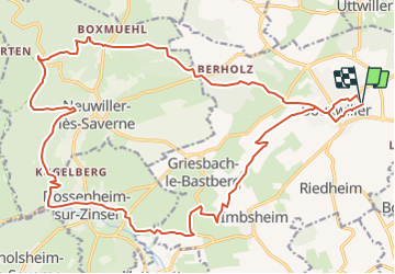
20 km | 27 km-effort
5h 9min
Yes
Trail On foot Bouxwiller - Sentier Géologique / Sentier des Chortens - Photo
On foot
PRO

On foot

Easy
Bouxwiller, Grand Est, Bas-Rhin, France
5.8 km | 7.6 km-effort
1h 42min
Yes
Trail Walking Bouxwiller - Boucle Imbsheim Blastberg - Photo
Walking
zazie

Walking

Easy
Bouxwiller, Grand Est, Bas-Rhin, France
7.4 km | 9.3 km-effort
1h 51min
Yes
Trail Walking Bouxwiller - Boucle Imbsheim Blastberg - Photo
Walking
zazie

Walking

Easy
Bouxwiller, Grand Est, Bas-Rhin, France
7.4 km | 9.3 km-effort
1h 51min
Yes
Trail Walking Bouxwiller - sentier geologique du Batsberg - Photo
Walking
fbertrand

Walking

Medium
Bouxwiller, Grand Est, Bas-Rhin, France
6 km | 7.8 km-effort
2h 31min
Yes
Trail Walking Bouxwiller - De Bouxwiller à Saverne - Photo
Walking
tracegps

Walking

Difficult
Bouxwiller, Grand Est, Bas-Rhin, France
21 km | 28 km-effort
5h 0min
No
Trail Horseback riding Bouxwiller - griesbach Melsheim - Photo
Horseback riding
Mumu67330

Horseback riding

Very easy
Bouxwiller, Grand Est, Bas-Rhin, France
12.8 km | 14.8 km-effort
2h 26min
No
Trail Walking Bouxwiller - Nouxwiller - Photo
Walking
bourdet

Walking

Very easy
Bouxwiller, Grand Est, Bas-Rhin, France
6.3 km | 7.8 km-effort
2h 32min
Yes
Trail Horseback riding Weiterswiller - remy - Photo
Horseback riding
Rémy Isenmann

Horseback riding

Difficult
Weiterswiller, Grand Est, Bas-Rhin, France
29 km | 38 km-effort
4h 59min
Yes


Close
My subscriptions