Trail Walking Poligny - Col de Chetive-Aiguille de Roche Noire. - Photo

Col de Chetive-Aiguille de Roche Noire.

© OpenStreetMap contributors
Length
Length
8.1 km
Max alt
Max alt
2058 m
Uphill gradient
Uphill gradient
771 m
Km-Effort
Km-Effort  
18.4 km
Min alt
Min alt
1375 m
Downhill gradient
Downhill gradient
764 m
Boucle
Boucle
Yes
Creation date :
2018-04-17 10:06:46.764
Updated on :
2018-04-17 10:06:46.764

(0 Reviews)

Walking
Walking
4h25
Difficulty : Medium

Scan this QR Code to open this trail in the SityTrail application

FREE GPS app for hiking

Logo SityTrail SityTrail

IGN / Geographical institutes

Download SityTrail from the App Store Download SityTrail from Google Play

Logo SityTrail SityTrail World

The world is yours!

Download SityTrail from the App Store Download SityTrail from Google Play Download SityTrail on Huawei AppGallery

About

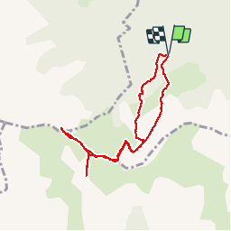
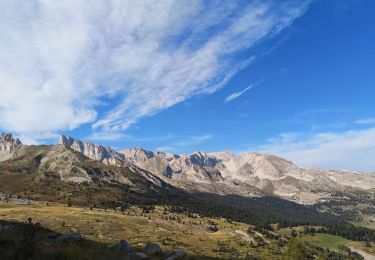
Trail Walking of 8.1 km to be discovered at Provence-Alpes-Côte d'Azur, Hautes-Alpes, Poligny. This trail is proposed by Dervalmarc.

Description

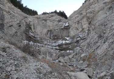
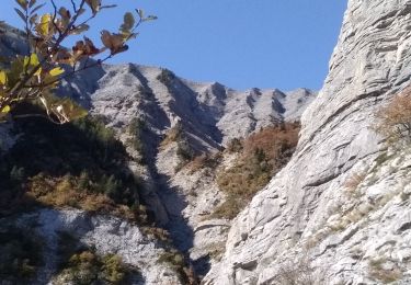
Montée tres raide à partir du col de Chetive jusqu'à la Cime.

Elevation profile

Photos

Points of interest

Point of interest Gap - Point 8 - Photo
Dervalmarc
GAP 

Positioning

Country:
France
Region :
Provence-Alpes-Côte d'Azur
Department/Province :
Hautes-Alpes
Municipality :
Poligny
Location:
Unknown
Start:(UTM)
263932 ; 4951092 (32T) N.

Trails nearby

Trail Walking Laye - Sentier de la Cuque prolongé - Photo
Walking
frederique.marti@laposte.net

Walking

Very easy
(1)
Laye, Provence-Alpes-Côte d'Azur, Hautes-Alpes, France
11.8 km | 19.7 km-effort
2h 24min
Yes
Trail Walking La Fare-en-Champsaur - Le Bois Vert Station de Laye  - Photo
Walking
sereton

Walking

Medium
(1)
La Fare-en-Champsaur, Provence-Alpes-Côte d'Azur, Hautes-Alpes, France
9.1 km | 13.1 km-effort
2h 44min
Yes
Trail Walking Poligny - Sommet du Chamois - Photo
Walking
Marco05

Walking

Difficult
Poligny, Provence-Alpes-Côte d'Azur, Hautes-Alpes, France
8 km | 18.6 km-effort
4h 13min
Yes
Trail On foot Le Noyer - Sentier botanique Dominique Villars - Photo
On foot
PRO

On foot

Easy
(1)
Le Noyer, Provence-Alpes-Côte d'Azur, Hautes-Alpes, France
3.5 km | 6.8 km-effort
1h 32min
Yes
Trail Walking Poligny - Cabane des pierres/Cascade ste Catherine. - Photo
Walking
Dervalmarc

Walking

Easy
Poligny, Provence-Alpes-Côte d'Azur, Hautes-Alpes, France
8.2 km | 13.2 km-effort
2h 43min
Yes
Trail Walking La Fare-en-Champsaur - Le Girolet  - Photo
Walking
nadd73

Walking

Medium
La Fare-en-Champsaur, Provence-Alpes-Côte d'Azur, Hautes-Alpes, France
11.6 km | 24 km-effort
4h 45min
Yes
Trail Walking La Fare-en-Champsaur - Le sommet des chamois  - Photo
Walking
PATGUSS

Walking

Very difficult
La Fare-en-Champsaur, Provence-Alpes-Côte d'Azur, Hautes-Alpes, France
18.2 km | 34 km-effort
7h 52min
Yes
Trail Walking Poligny - Col de Chétive /Cime du Chamois.  - Photo
Walking
Dervalmarc

Walking

Medium
Poligny, Provence-Alpes-Côte d'Azur, Hautes-Alpes, France
7.1 km | 16.3 km-effort
3h 57min
Yes
Trail Walking Le Dévoluy - Sommet de Raz de Bec. 21/09/18 - Photo
Walking
Dervalmarc

Walking

Difficult
Le Dévoluy, Provence-Alpes-Côte d'Azur, Hautes-Alpes, France
11.9 km | 23 km-effort
5h 25min
Yes


Close
My subscriptions