Trail Walking Garde-Colombe - R33   La Montagne de Saint Genis - Photo

Les Hautes Alpes à découvrir ! GUIDE+

© OpenStreetMap contributors
Length
Length
11.4 km
Max alt
Max alt
1156 m
Uphill gradient
Uphill gradient
606 m
Km-Effort
Km-Effort  
19.4 km
Min alt
Min alt
656 m
Downhill gradient
Downhill gradient
602 m
Boucle
Boucle
Yes
Creation date :
2018-03-23 05:41:04.345
Updated on :
2018-10-17 06:24:32.282

(0 Reviews)

Walking
Walking
3h59
Difficulty : Medium

Scan this QR Code to open this trail in the SityTrail application

FREE GPS app for hiking

Logo SityTrail SityTrail

IGN / Geographical institutes

Download SityTrail from the App Store Download SityTrail from Google Play

Logo SityTrail SityTrail World

The world is yours!

Download SityTrail from the App Store Download SityTrail from Google Play Download SityTrail on Huawei AppGallery

About

Trail Walking of 11.4 km to be discovered at Provence-Alpes-Côte d'Azur, Hautes-Alpes, Garde-Colombe. This trail is proposed by Camping Les Rives du Lac.

Description

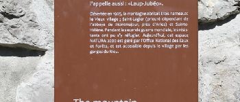
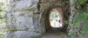
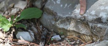
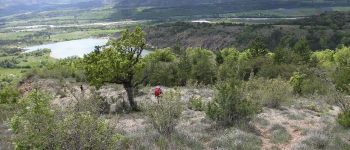
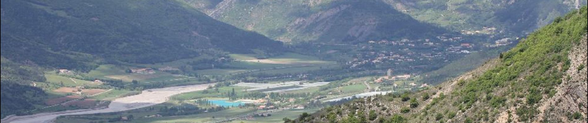
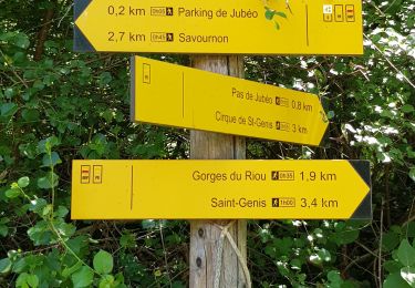
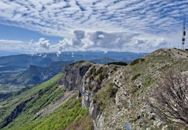
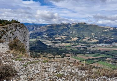
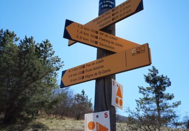
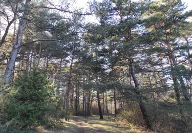
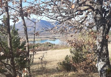
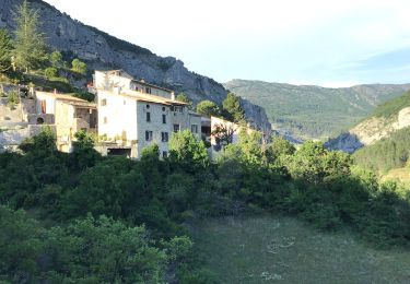
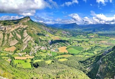
Hiking to do when it's not too hot. It allows to discover the beautiful gorges of Riou, and to bathe there. The most experienced hikers can continue on the ridges of Saint Genis, which offer a magnificent panorama. Departure of the tiny and pretty village of Saint-Genis; parking below the cemetery, then walk up to recover the trail. Many fossils on the way (as in many places in the region.) On the way down, the path is less marked, and sometimes it is marked but do not follow it! So follow the map. At the bottom, we arrive at the stream that we cross on the bridge and we reach the starting point by the small road. If you have not dared to cool off in the stream, you can, by taking the car, join the water of the Riou for a well deserved bath. (refreshments in summer)

Elevation profile

Photos

Points of interest

Point of interest Garde-Colombe - Depart de Saint Genis - Photo
CampingLesRivesduLac
GARDE-COLOMBE 
Point of interest Garde-Colombe - Le long du Riou - Photo
CampingLesRivesduLac
GARDE-COLOMBE 
Point of interest Garde-Colombe - Bifurcation Porte Sereine - Photo
CampingLesRivesduLac
Point of interest Garde-Colombe - Porte Sereine - Photo
CampingLesRivesduLac
GARDE-COLOMBE 

Positioning

Country:
France
Region :
Provence-Alpes-Côte d'Azur
Department/Province :
Hautes-Alpes
Municipality :
Garde-Colombe
Location:
Unknown
Start:(UTM)
720754 ; 4917861 (31T) N.

Trails nearby

Trail Walking Savournon - Reco Jubeo + 250 - Photo
Walking
claude nier

Walking

Medium
Savournon, Provence-Alpes-Côte d'Azur, Hautes-Alpes, France
10 km | 13.3 km-effort
3h 4min
Yes
Trail Walking Serres - Rocher de Beaumont - Photo
Walking
Marco05

Walking

Difficult
Serres, Provence-Alpes-Côte d'Azur, Hautes-Alpes, France
11.3 km | 23 km-effort
5h 19min
No
Trail On foot Garde-Colombe - Revuaire - Photo
On foot
Marco05

On foot

Difficult
Garde-Colombe, Provence-Alpes-Côte d'Azur, Hautes-Alpes, France
12.1 km | 21 km-effort
4h 42min
Yes
Trail Walking Garde-Colombe - Le réduire.. gorge du riou - Photo
Walking
gibello

Walking

Medium
Garde-Colombe, Provence-Alpes-Côte d'Azur, Hautes-Alpes, France
12.1 km | 21 km-effort
5h 3min
Yes
Trail Walking Laragne-Montéglin - Vieil Arzellier/Vieil Eyguians.21/02/21. - Photo
Walking
Dervalmarc

Walking

Easy
Laragne-Montéglin, Provence-Alpes-Côte d'Azur, Hautes-Alpes, France
3.5 km | 4.7 km-effort
59min
No
Trail Walking Garde-Colombe - SAINT GENIS Dep lac du Riou . Forte Sereine  gorges du Riou o m s    - Photo
Walking
RobinMicheline

Walking

Medium
Garde-Colombe, Provence-Alpes-Côte d'Azur, Hautes-Alpes, France
10.6 km | 17.4 km-effort
3h 10min
Yes
Trail Mountain bike Garde-Colombe - Pas du Colombier - Photo
Mountain bike
cazycricri

Mountain bike

Very difficult
Garde-Colombe, Provence-Alpes-Côte d'Azur, Hautes-Alpes, France
29 km | 41 km-effort
3h 10min
Yes
Trail Walking Garde-Colombe - Plan d’eau de St Genis  - Photo
Walking
Pierrannick

Walking

Easy
Garde-Colombe, Provence-Alpes-Côte d'Azur, Hautes-Alpes, France
4.2 km | 5.2 km-effort
1h 37min
No
Trail Walking Trescléoux - Le Suillet via Le Rocher Pointu au Départ de Trescléoux - Photo
Walking
PapouBertrand

Walking

Very difficult
Trescléoux, Provence-Alpes-Côte d'Azur, Hautes-Alpes, France
13.2 km | 25 km-effort
6h 20min
Yes


Close
My subscriptions