Trail Walking Saint-Venant - saint VENANT - Photo
© OpenStreetMap contributors
Length
Length
12.5 km
Max alt
Max alt
22 m
Uphill gradient
Uphill gradient
43 m
Km-Effort
Km-Effort  
13.1 km
Min alt
Min alt
13 m
Downhill gradient
Downhill gradient
43 m
Boucle
Boucle
Yes
Creation date :
2018-04-17 19:09:51.19
Updated on :
2018-04-17 19:09:51.19

(0 Reviews)

Walking
Walking
2h55
Difficulty : Easy

Scan this QR Code to open this trail in the SityTrail application

FREE GPS app for hiking

Logo SityTrail SityTrail

IGN / Geographical institutes

Download SityTrail from the App Store Download SityTrail from Google Play

Logo SityTrail SityTrail World

The world is yours!

Download SityTrail from the App Store Download SityTrail from Google Play Download SityTrail on Huawei AppGallery

About

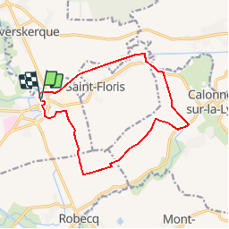
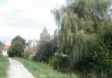
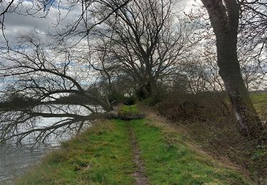
Trail Walking of 12.5 km to be discovered at Hauts-de-France, Pas-de-Calais, Saint-Venant. This trail is proposed by eaea7charles.

Description

Randonnée facile de 12 km au départ de l'église de saint VENANT vers la lys , en empruntant le GR de pays tour de la Lys

Elevation profile

Positioning

Country:
France
Region :
Hauts-de-France
Department/Province :
Pas-de-Calais
Municipality :
Saint-Venant
Location:
Unknown
Start:(UTM)
468132 ; 5608101 (31U) N.

Trails nearby

Trail Walking Haverskerque - Circuit du Tannay - Haverskerque - Photo
Walking
tracegps

Walking

Easy
(1)
Haverskerque, Hauts-de-France, Nord, France
5.9 km | 6.3 km-effort
1h 30min
Yes
Trail Walking Haverskerque - Haverskerque 3 clochers 10.8 km - Photo
Walking
Blourouce

Walking

Medium
(1)
Haverskerque, Hauts-de-France, Nord, France
10.8 km | 11.5 km-effort
2h 36min
Yes
Trail Other activity Saint-Venant - le_sentier_des_deux_ecluses - Photo
Other activity
LaHAL

Other activity

Medium
Saint-Venant, Hauts-de-France, Pas-de-Calais, France
12.5 km | 13 km-effort
Unknown
Yes
Trail Walking Guarbecque - 2015-08-24T22:07:05Z - Photo
Walking
samsam62

Walking

Very easy
(2)
Guarbecque, Hauts-de-France, Pas-de-Calais, France
38 km | 42 km-effort
9h 7min
Yes
Trail Walking Busnes - Le Béniau - Busnes - Photo
Walking
tracegps

Walking

Medium
Busnes, Hauts-de-France, Pas-de-Calais, France
13 km | 13.6 km-effort
3h 0min
Yes
Trail Walking Robecq - Sentier les tchiens - Robecq - Photo
Walking
tracegps

Walking

Medium
(1)
Robecq, Hauts-de-France, Pas-de-Calais, France
12 km | 12.7 km-effort
3h 0min
Yes
Trail Walking Haverskerque - Circuit des 3 clochers (Haverskerque) - Photo
Walking
tracegps

Walking

Medium
Haverskerque, Hauts-de-France, Nord, France
10.8 km | 11.5 km-effort
2h 45min
Yes
Trail Walking Busnes - Busnes et le canal d'aire. - Photo
Walking
BrassensJC

Walking

Medium
Busnes, Hauts-de-France, Pas-de-Calais, France
6.9 km | 7.2 km-effort
1h 38min
Yes
Trail On foot Robecq - ROBECQ 12.7 km et 46m de déniv. - Photo
On foot
eaea7charles

On foot

Easy
Robecq, Hauts-de-France, Pas-de-Calais, France
12.8 km | 13.4 km-effort
3h 0min
Yes


Close
My subscriptions