Trail Running Saint-Auban-d'Oze - Trail 01 - Le Cirque de Villauret - Photo

Les Hautes Alpes à découvrir ! GUIDE+

© OpenStreetMap contributors
Length
Length
9.6 km
Max alt
Max alt
1556 m
Uphill gradient
Uphill gradient
778 m
Km-Effort
Km-Effort  
19.9 km
Min alt
Min alt
991 m
Downhill gradient
Downhill gradient
779 m
Boucle
Boucle
Yes
Creation date :
2018-03-23 05:39:33.133
Updated on :
2019-05-14 06:49:52.216

(0 Reviews)

Running
Running
2h00
Difficulty : Difficult

Scan this QR Code to open this trail in the SityTrail application

FREE GPS app for hiking

Logo SityTrail SityTrail

IGN / Geographical institutes

Download SityTrail from the App Store Download SityTrail from Google Play

Logo SityTrail SityTrail World

The world is yours!

Download SityTrail from the App Store Download SityTrail from Google Play Download SityTrail on Huawei AppGallery

About

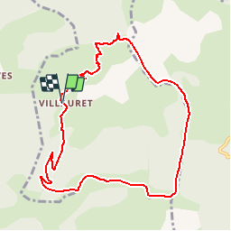
Trail Running of 9.6 km to be discovered at Provence-Alpes-Côte d'Azur, Hautes-Alpes, Saint-Auban-d'Oze. This trail is proposed by Camping Les Rives du Lac.

Description

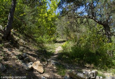
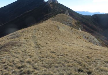
Au départ de la ferme du Villauret (après le village du Saix), suivre le GR en direction du col. Au col, bifurquer à droite en empruntant un sentier assez raide. Le sentier se perd un peu… Mais l’orientation est évidente car il faut toujours rester sur la crête, qui est souvent dégagée.

Elevation profile

Photos

Positioning

Country:
France
Region :
Provence-Alpes-Côte d'Azur
Department/Province :
Hautes-Alpes
Municipality :
Saint-Auban-d'Oze
Location:
Unknown
Start:(UTM)
726903 ; 4928351 (31T) N.

Trails nearby

Trail Walking Le Saix - R08 La boucle des cascades jaunes - Photo
Walking
GUIDE+

Walking

Very easy
(1)
Le Saix, Provence-Alpes-Côte d'Azur, Hautes-Alpes, France
5.5 km | 10.3 km-effort
2h 10min
Yes
Trail Mountain bike Veynes - VTT03 - Tous les Eygaux - Photo
Mountain bike
GUIDE+

Mountain bike

Medium
(2)
Veynes, Provence-Alpes-Côte d'Azur, Hautes-Alpes, France
23 km | 31 km-effort
1h 31min
Yes
Trail Walking Le Saix - R07   le fai - Photo
Walking
GUIDE+

Walking

Easy
(4)
Le Saix, Provence-Alpes-Côte d'Azur, Hautes-Alpes, France
5.1 km | 8 km-effort
1h 42min
Yes
Trail Running Veynes - Trail 05 - Le Défi des Argouses - Photo
Running
GUIDE+

Running

Difficult
(3)
Veynes, Provence-Alpes-Côte d'Azur, Hautes-Alpes, France
9 km | 11.9 km-effort
48min
Yes
Trail Mountain bike Châteauneuf-d'Oze - ceuse9 avril 2012 - Photo
Mountain bike
GUIDE
harydh

Mountain bike

Medium
(2)
Châteauneuf-d'Oze, Provence-Alpes-Côte d'Azur, Hautes-Alpes, France
18.1 km | 26 km-effort
Unknown
Yes
Trail Running Le Saix - Trail 10 - La Traversée d'Aujour - Photo
Running
GUIDE+

Running

Difficult
Le Saix, Provence-Alpes-Côte d'Azur, Hautes-Alpes, France
16.4 km | 31 km-effort
3h 0min
Yes
Trail Walking Le Saix - R36 - Aujour depuis Clausonne - Photo
Walking
GUIDE+

Walking

Difficult
Le Saix, Provence-Alpes-Côte d'Azur, Hautes-Alpes, France
11.9 km | 22 km-effort
4h 27min
Yes
Trail Mountain bike Le Saix - VTT19 - Le tour d'Aujour - Photo
Mountain bike
GUIDE+

Mountain bike

Very difficult
Le Saix, Provence-Alpes-Côte d'Azur, Hautes-Alpes, France
24 km | 40 km-effort
2h 25min
Yes
Trail Mountain bike Le Saix - VTT18 - Col de Peyssier - Photo
Mountain bike
GUIDE+

Mountain bike

Medium
Le Saix, Provence-Alpes-Côte d'Azur, Hautes-Alpes, France
20 km | 32 km-effort
2h 15min
Yes


Close
My subscriptions