Trail Nordic walking Caillac - la cévenne de Crayssac - Photo

la cévenne de Crayssac

 rouky
rouky

User

© OpenStreetMap contributors
Length
Length
16.1 km
Max alt
Max alt
291 m
Uphill gradient
Uphill gradient
464 m
Km-Effort
Km-Effort  
22 km
Min alt
Min alt
110 m
Downhill gradient
Downhill gradient
464 m
Boucle
Boucle
Yes
Creation date :
2014-12-10 00:00:00.0
Updated on :
2014-12-10 00:00:00.0

(0 Reviews)

Nordic walking
Nordic walking
2h41
Difficulty : Medium

Scan this QR Code to open this trail in the SityTrail application

FREE GPS app for hiking

Logo SityTrail SityTrail

IGN / Geographical institutes

Download SityTrail from the App Store Download SityTrail from Google Play

Logo SityTrail SityTrail World

The world is yours!

Download SityTrail from the App Store Download SityTrail from Google Play Download SityTrail on Huawei AppGallery

About

Trail Nordic walking of 16.1 km to be discovered at Occitania, Lot, Caillac. This trail is proposed by rouky.

Description

Départ de Caillac pour rejoindre L'impernal de luzech par le plateau et retour par le chemin de crète

Elevation profile

Photos

Points of interest

Point of interest Luzech - Point de vue - Photo
rouky
LUZECH 
Point of interest Luzech - Point de vue - Photo
rouky
LUZECH 

Positioning

Country:
France
Region :
Occitania
Department/Province :
Lot
Municipality :
Caillac
Location:
Unknown
Start:(UTM)
367314 ; 4928001 (31T) N.

Trails nearby

Trail Walking Saint-Vincent-Rive-d'Olt - St Vincent-rive  d’Holt (Lot) - Photo
Walking
houbart

Walking

Difficult
(1)
Saint-Vincent-Rive-d'Olt, Occitania, Lot, France
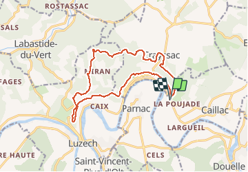
11.6 km | 17.4 km-effort
3h 57min
Yes
Trail Walking Crayssac - Crayssac Cévennes  - Photo
Walking
GUIDE
antignacs

Walking

Very easy
Crayssac, Occitania, Lot, France
6.3 km | 9.1 km-effort
1h 43min
No
Trail Walking Luzech - De Luzech à Castelfranc - Photo
Walking
tracegps

Walking

Very difficult
Luzech, Occitania, Lot, France
24 km | 32 km-effort
5h 0min
Yes
Trail Walking Saint-Vincent-Rive-d'Olt - Point de vue sur le cingle de Luzech - Photo
Walking
tracegps

Walking

Difficult
(1)
Saint-Vincent-Rive-d'Olt, Occitania, Lot, France
4.6 km | 7.3 km-effort
1h 30min
Yes
Trail Walking Calamane - Calamane  - Photo
Walking
GUIDE
antignacs

Walking

Very easy
Calamane, Occitania, Lot, France
12 km | 15.1 km-effort
2h 36min
Yes
Trail Walking Mercuès - Mercues Caillac  - Photo
Walking
GUIDE
antignacs

Walking

Very easy
Mercuès, Occitania, Lot, France
8.1 km | 9.7 km-effort
1h 59min
Yes
Trail Hybrid bike Mercuès - Voie verte Mercues - Photo
Hybrid bike
GUIDE
antignacs

Hybrid bike

Very easy
Mercuès, Occitania, Lot, France
10.9 km | 12.7 km-effort
1h 57min
Yes
Trail Walking Mercuès - Château les bouysses  - Photo
Walking
GUIDE
antignacs

Walking

Very easy
Mercuès, Occitania, Lot, France
3.5 km | 4.2 km-effort
52min
Yes
Trail On foot Calamane - Il suffit de passer les ponts - 7,4km - Photo
On foot
PRO

On foot

Easy
Calamane, Occitania, Lot, France
7.4 km | 9.7 km-effort
2h 12min
Yes


Close
My subscriptions