![](/images/other/stat-length.png)
![Excursión Bici de montaña Jalhay - 20180808 Yeyette chez Popol - Photo](https://media.geolcdn.com/t/1900/400/ext.pjpeg?maxdim=2&url=https%3A%2F%2Fservices.sitytrail.com%2FGeolivesWS%2FDownloadMedia.ashx%3FTrailID%3D1018715%26Media%3D20180808202018.jpg)
20180808 Yeyette chez Popol
Yeyette VTT team
Plus vî, plus sot
![Longitud](/images/other/stat-length.png)
Longitud
29 km
![Altitud máxima](https://static1.geolcdn.com/siteimages/upload/files/1508320355ic_sort_altitude_max_24dp.png)
Altitud máxima
373 m
![Desnivel positivo](https://static1.geolcdn.com/siteimages/upload/files/1508320355ic_sort_den_pos_24dp.png)
Desnivel positivo
458 m
![Km-Effort](/images/other/stat-length.png)
Km-Effort
35 km
![Altitud mínima](https://static1.geolcdn.com/siteimages/upload/files/1508320355ic_sort_altitude_min_24dp.png)
Altitud mínima
232 m
![Desnivel negativo](https://static1.geolcdn.com/siteimages/upload/files/1508320355ic_sort_den_neg_24dp.png)
Desnivel negativo
460 m
![Boucle](https://static1.geolcdn.com/siteimages/upload/files/16400158638029165_repeat_loop_refresh_sync_direction_icon.png)
Boucle
Sí
Fecha de creación :
2018-10-09 11:54:27.592
Última modificación :
2018-10-09 11:54:27.592
![Bici de montaña](https://static1.geolcdn.com/sitytour/trail-icons/202.png)
2h18
Dificultad : Medio
![Escanee este código QR para abrir la excursión en la aplicación SityTrail](https://capi.geolives.com/qq0zvz2zws4bq2lad0pu/sitytour/trails/1018715/qr.png?size=200)
Aplicación GPS de excursión GRATIS
A propósito
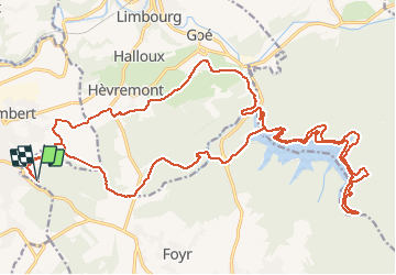
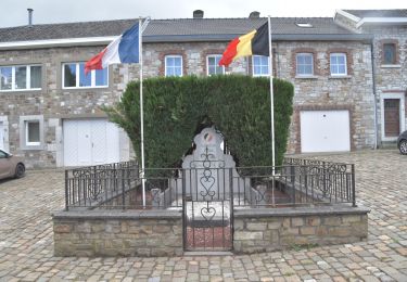
Ruta Bici de montaña de 29 km a descubrir en Valonia, Lieja, Jalhay. Esta ruta ha sido propuesta por Yeyette VTT team.
Descripción
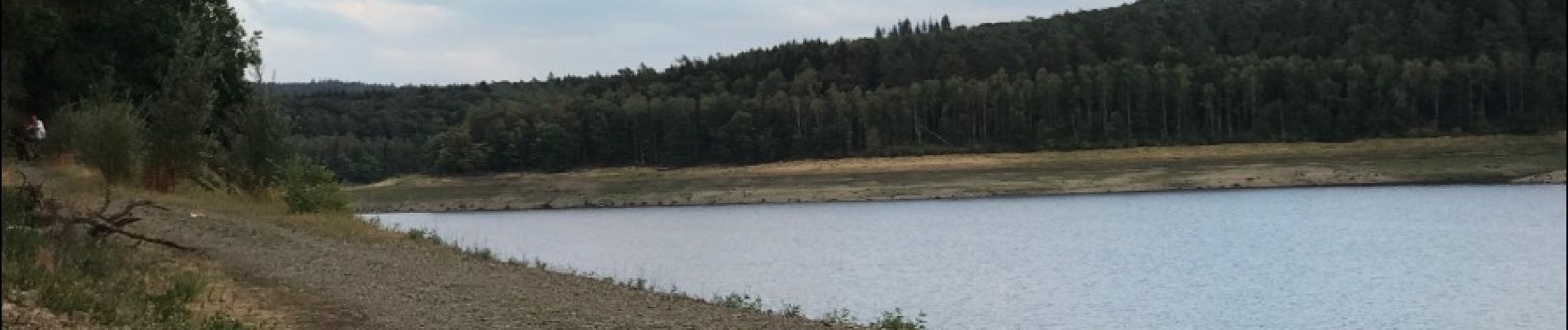
Avec le côté nord de la Gileppe bien asséché : voir le profil de dénivelé.
Localización
País:
Belgium
Región :
Valonia
Departamento/provincia :
Lieja
Municipio :
Jalhay
Localidad:
Jalhay
Salida:(Dec)
Salida:(UTM)
705715 ; 5607095 (31U) N.
Comentarios
Excursiones cerca
![Excursión Senderismo Limbourg - RB-Lg-28_Limbourg - Photo](https://media.geolcdn.com/t/375/260/ext.jpg?maxdim=2&url=https%3A%2F%2Fservices.sitytrail.com%2FGeolivesWS%2FDownloadMedia.ashx%3FTrailID%3D402093%26Media%3D979895a6-f139-4f7a-8335-2e926c1b89c7.jpg)
![Senderismo Senderismo](https://static1.geolcdn.com/sitytour/trail-icons/101.png)
RB-Lg-28_Limbourg
Senderismo
(5)
Limbourg,
Valonia,
Lieja,
Belgium
![](/images/other/stat-length.png)
19,9 km | 26 km-effort
5h 49min
![](https://static1.geolcdn.com/siteimages/upload/files/16400158638029165_repeat_loop_refresh_sync_direction_icon.png)
Sí
![Excursión Senderismo Verviers - Grand vivier - Cossart - Photo](https://media.geolcdn.com/t/375/260/ext.jpg?maxdim=2&url=https%3A%2F%2Fstatic1.geolcdn.com%2Fsiteimages%2Fupload%2Ffiles%2F1553511878bg_sport_marche.png)
![Senderismo Senderismo](https://static1.geolcdn.com/sitytour/trail-icons/101.png)
Grand vivier - Cossart
Senderismo
Fácil
(5)
Verviers,
Valonia,
Lieja,
Belgium
![](/images/other/stat-length.png)
4,7 km | 6,4 km-effort
1h 26min
![](https://static1.geolcdn.com/siteimages/upload/files/16400158638029165_repeat_loop_refresh_sync_direction_icon.png)
Sí
![Excursión Senderismo Jalhay - La Gileppe - Bois de la Borchêne - Photo](https://media.geolcdn.com/t/375/260/ext.jpg?maxdim=2&url=https%3A%2F%2Fmedia.geolcdn.com%2Ff%2Fe6c1c191-9060-48ef-8a65-d77cc5b69a34.jpg)
![Senderismo Senderismo](https://static1.geolcdn.com/sitytour/trail-icons/101.png)
La Gileppe - Bois de la Borchêne
Senderismo
Fácil
(2)
Jalhay,
Valonia,
Lieja,
Belgium
![](/images/other/stat-length.png)
7,6 km | 9,8 km-effort
2h 13min
![](https://static1.geolcdn.com/siteimages/upload/files/16400158638029165_repeat_loop_refresh_sync_direction_icon.png)
Sí
![Excursión Senderismo Theux - 20220901 - Jehanster 5.3 Km - Photo](https://media.geolcdn.com/t/375/260/ext.jpg?maxdim=2&url=https%3A%2F%2Fmedia.geolcdn.com%2Ff%2F21513cc5-be82-4323-813b-3b74ae756c6a.JPG)
![Senderismo Senderismo](https://static1.geolcdn.com/sitytour/trail-icons/101.png)
20220901 - Jehanster 5.3 Km
Senderismo
Medio
(1)
Theux,
Valonia,
Lieja,
Belgium
![](/images/other/stat-length.png)
5,3 km | 6,8 km-effort
1h 32min
![](https://static1.geolcdn.com/siteimages/upload/files/16400158638029165_repeat_loop_refresh_sync_direction_icon.png)
Sí
![Excursión Senderismo Jalhay - 2021-11-16_21h27m43_Cirkwi-Balade_à_Jalhay-Royompré_-_47 - Photo](https://media.geolcdn.com/t/375/260/ext.jpg?maxdim=2&url=https%3A%2F%2Fmedia.geolcdn.com%2Ff%2F94c262e0-20e7-4ae2-8b45-01b4c31da73b.jpg)
![Senderismo Senderismo](https://static1.geolcdn.com/sitytour/trail-icons/101.png)
2021-11-16_21h27m43_Cirkwi-Balade_à_Jalhay-Royompré_-_47
Senderismo
Fácil
(2)
Jalhay,
Valonia,
Lieja,
Belgium
![](/images/other/stat-length.png)
11 km | 13,9 km-effort
3h 9min
![](https://static1.geolcdn.com/siteimages/upload/files/16400158638029165_repeat_loop_refresh_sync_direction_icon.png)
Sí
![Excursión Senderismo Jalhay - 20210205 - La Gileppe 7.3 Km - Photo](https://media.geolcdn.com/t/375/260/ext.jpg?maxdim=2&url=https%3A%2F%2Fmedia.geolcdn.com%2Ff%2F9fd2d099-e737-420f-8e13-a40404a282cd.JPG)
![Senderismo Senderismo](https://static1.geolcdn.com/sitytour/trail-icons/101.png)
20210205 - La Gileppe 7.3 Km
Senderismo
Medio
(1)
Jalhay,
Valonia,
Lieja,
Belgium
![](/images/other/stat-length.png)
7,6 km | 9,9 km-effort
2h 24min
![](https://static1.geolcdn.com/siteimages/upload/files/16400158638029165_repeat_loop_refresh_sync_direction_icon.png)
Sí
![Excursión Senderismo Limbourg - 20200606 - Hèvremont 8 Km - Photo](https://media.geolcdn.com/t/375/260/ext.jpg?maxdim=2&url=https%3A%2F%2Fmedia.geolcdn.com%2Ff%2F8311f513-ce09-455a-b0ac-51a7423b07df.jpg)
![Senderismo Senderismo](https://static1.geolcdn.com/sitytour/trail-icons/101.png)
20200606 - Hèvremont 8 Km
Senderismo
Difícil
(1)
Limbourg,
Valonia,
Lieja,
Belgium
![](/images/other/stat-length.png)
7,9 km | 10,7 km-effort
1h 34min
![](https://static1.geolcdn.com/siteimages/upload/files/16400158638029165_repeat_loop_refresh_sync_direction_icon.png)
Sí
![Excursión A pie Theux - Chemin des Sources - Introduction to hiking in Polleur - Photo](https://media.geolcdn.com/t/375/260/ext.jpg?maxdim=2&url=https%3A%2F%2Fmedia.geolcdn.com%2Ff%2F7fa33f7a-cba1-4f6e-98fb-216ec34e6071.JPEG)
![A pie A pie](https://static1.geolcdn.com/sitytour/trail-icons/100.png)
Chemin des Sources - Introduction to hiking in Polleur
A pie
Fácil
(1)
Theux,
Valonia,
Lieja,
Belgium
![](/images/other/stat-length.png)
7,5 km | 9,9 km-effort
2h 14min
![](https://static1.geolcdn.com/siteimages/upload/files/16400158638029165_repeat_loop_refresh_sync_direction_icon.png)
Sí
![Excursión Senderismo Jalhay - La Gileppe - Photo](https://media.geolcdn.com/t/375/260/ext.jpg?maxdim=2&url=https%3A%2F%2Fmedia.geolcdn.com%2Ff%2F9374fc26-a93b-4b0a-b10a-5ceb74ed5a19.jpg)
![Senderismo Senderismo](https://static1.geolcdn.com/sitytour/trail-icons/101.png)