![](/images/other/stat-length.png)
![Excursión Senderismo Oderen - MLS 30mai22 Chaumes et forêts entre Fellering et Siebach - Photo](https://media.geolcdn.com/t/1900/400/ext.pjpeg?maxdim=2&url=https%3A%2F%2Fstatic1.geolcdn.com%2Fsiteimages%2Fupload%2Ffiles%2F1553511878bg_sport_marche.png)
MLS 30mai22 Chaumes et forêts entre Fellering et Siebach
argonneuweg
Usuario
![Longitud](/images/other/stat-length.png)
Longitud
6,9 km
![Altitud máxima](https://static1.geolcdn.com/siteimages/upload/files/1508320355ic_sort_altitude_max_24dp.png)
Altitud máxima
767 m
![Desnivel positivo](https://static1.geolcdn.com/siteimages/upload/files/1508320355ic_sort_den_pos_24dp.png)
Desnivel positivo
333 m
![Km-Effort](/images/other/stat-length.png)
Km-Effort
11,3 km
![Altitud mínima](https://static1.geolcdn.com/siteimages/upload/files/1508320355ic_sort_altitude_min_24dp.png)
Altitud mínima
443 m
![Desnivel negativo](https://static1.geolcdn.com/siteimages/upload/files/1508320355ic_sort_den_neg_24dp.png)
Desnivel negativo
334 m
![Boucle](https://static1.geolcdn.com/siteimages/upload/files/16400158638029165_repeat_loop_refresh_sync_direction_icon.png)
Boucle
Sí
Fecha de creación :
2022-05-04 07:53:55.0
Última modificación :
2022-05-05 17:30:59.996
![Senderismo](https://static1.geolcdn.com/sitytour/trail-icons/101.png)
1h59
Dificultad : Difícil
![Escanee este código QR para abrir la excursión en la aplicación SityTrail](https://capi.geolives.com/qq0zvz2zws4bq2lad0pu/sitytour/trails/3228936/qr.png?size=200)
Aplicación GPS de excursión GRATIS
A propósito
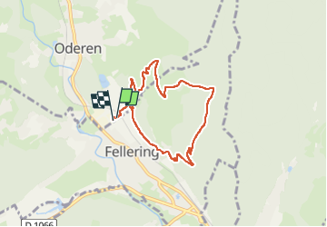
Ruta Senderismo de 6,9 km a descubrir en Gran Este, Alto Rin, Oderen. Esta ruta ha sido propuesta por argonneuweg.
Descripción
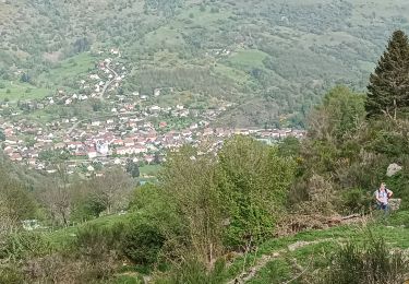
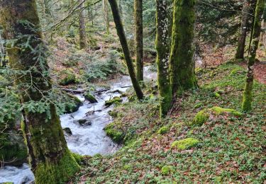
La première partie de cette rando consiste en une montée assez raide au travers des chaumes mais avec des vues splendides sur la vallée et les alentours. Puis une descente douce et longue dans la forêt.
Ne pas oublier les bâtons
Localización
País:
France
Región :
Gran Este
Departamento/provincia :
Alto Rin
Municipio :
Oderen
Localidad:
Unknown
Salida:(Dec)
Salida:(UTM)
349260 ; 5307238 (32T) N.
Comentarios
Excursiones cerca
![Excursión Senderismo Linthal - Markstein - Photo](https://media.geolcdn.com/t/375/260/ext.jpg?maxdim=2&url=https%3A%2F%2Fservices.sitytrail.com%2FGeolivesWS%2FDownloadMedia.ashx%3FTrailID%3D266212%26Media%3Dfix__20140413115328.jpg)
![Senderismo Senderismo](https://static1.geolcdn.com/sitytour/trail-icons/101.png)
Markstein
Senderismo
Medio
(1)
Linthal,
Gran Este,
Alto Rin,
France
![](/images/other/stat-length.png)
14 km | 19,8 km-effort
4h 45min
![](https://static1.geolcdn.com/siteimages/upload/files/16400158638029165_repeat_loop_refresh_sync_direction_icon.png)
Sí
![Excursión Senderismo Fellering - Felsach _chapelle ST Nicolas_frenz - Photo](https://media.geolcdn.com/t/375/260/ext.jpg?maxdim=2&url=https%3A%2F%2Fstatic1.geolcdn.com%2Fsiteimages%2Fupload%2Ffiles%2F1553511878bg_sport_marche.png)
![Senderismo Senderismo](https://static1.geolcdn.com/sitytour/trail-icons/101.png)
Felsach _chapelle ST Nicolas_frenz
Senderismo
Difícil
(3)
Fellering,
Gran Este,
Alto Rin,
France
![](/images/other/stat-length.png)
9,6 km | 16,5 km-effort
3h 45min
![](https://static1.geolcdn.com/siteimages/upload/files/16400158638029165_repeat_loop_refresh_sync_direction_icon.png)
Sí
![Excursión A pie Lautenbachzell - Parking Bellevue - Hundsrucken - Markstein - Photo](https://media.geolcdn.com/t/375/260/ext.jpg?maxdim=2&url=https%3A%2F%2Fstatic1.geolcdn.com%2Fsiteimages%2Fupload%2Ffiles%2F1545311037marcheuse_200dpi.jpg)
![A pie A pie](https://static1.geolcdn.com/sitytour/trail-icons/100.png)
Parking Bellevue - Hundsrucken - Markstein
A pie
Medio
(1)
Lautenbachzell,
Gran Este,
Alto Rin,
France
![](/images/other/stat-length.png)
9,4 km | 13 km-effort
Desconocido
![](https://static1.geolcdn.com/siteimages/upload/files/16400158638029165_repeat_loop_refresh_sync_direction_icon.png)
Sí
![Excursión Senderismo Oderen - 6146369-Chapelle St Nicolas 2 - Photo](https://media.geolcdn.com/t/375/260/ext.jpg?maxdim=2&url=https%3A%2F%2Fstatic1.geolcdn.com%2Fsiteimages%2Fupload%2Ffiles%2F1553511878bg_sport_marche.png)
![Senderismo Senderismo](https://static1.geolcdn.com/sitytour/trail-icons/101.png)
6146369-Chapelle St Nicolas 2
Senderismo
Medio
(1)
Oderen,
Gran Este,
Alto Rin,
France
![](/images/other/stat-length.png)
10,9 km | 17,9 km-effort
3h 41min
![](https://static1.geolcdn.com/siteimages/upload/files/16400158638029165_repeat_loop_refresh_sync_direction_icon.png)
Sí
![Excursión Senderismo Oderen - Oderen Bergenbach Langenbach - Photo](https://media.geolcdn.com/t/375/260/ext.jpg?maxdim=2&url=https%3A%2F%2Fmedia.geolcdn.com%2Ff%2F05163254-f106-4300-b7bd-e85eb3e624ac.jpg)
![Senderismo Senderismo](https://static1.geolcdn.com/sitytour/trail-icons/101.png)
Oderen Bergenbach Langenbach
Senderismo
Medio
Oderen,
Gran Este,
Alto Rin,
France
![](/images/other/stat-length.png)
7,1 km | 11,6 km-effort
3h 40min
![](https://static1.geolcdn.com/siteimages/upload/files/16400158638029165_repeat_loop_refresh_sync_direction_icon.png)
No
![Excursión Senderismo Mollau - Le rossberg - Photo](https://media.geolcdn.com/t/375/260/ext.jpg?maxdim=2&url=https%3A%2F%2Fmedia.geolcdn.com%2Ff%2Fe1c84c66-d799-45c0-a7df-12e4ffcf0bb2.jpg)
![Senderismo Senderismo](https://static1.geolcdn.com/sitytour/trail-icons/101.png)
![Excursión Senderismo Oderen - trek alsacien (1ère étape) - Photo](https://media.geolcdn.com/t/375/260/ext.jpg?maxdim=2&url=https%3A%2F%2Fmedia.geolcdn.com%2Ff%2F787fe892-71a8-4daf-8eb0-6ad69c3ebb22.jpg)
![Senderismo Senderismo](https://static1.geolcdn.com/sitytour/trail-icons/101.png)
trek alsacien (1ère étape)
Senderismo
Medio
Oderen,
Gran Este,
Alto Rin,
France
![](/images/other/stat-length.png)
9,2 km | 18,1 km-effort
4h 0min
![](https://static1.geolcdn.com/siteimages/upload/files/16400158638029165_repeat_loop_refresh_sync_direction_icon.png)
No
![Excursión Senderismo Ventron - Rando des Marcheurs..22/02/2024... - Photo](https://media.geolcdn.com/t/375/260/ext.jpg?maxdim=2&url=https%3A%2F%2Fmedia.geolcdn.com%2Ff%2Ff6554992-36c0-4327-9104-b1bea69cd994.jpg)
![Senderismo Senderismo](https://static1.geolcdn.com/sitytour/trail-icons/101.png)
Rando des Marcheurs..22/02/2024...
Senderismo
Muy difícil
Ventron,
Gran Este,
Vosgos,
France
![](/images/other/stat-length.png)
19,5 km | 31 km-effort
5h 4min
![](https://static1.geolcdn.com/siteimages/upload/files/16400158638029165_repeat_loop_refresh_sync_direction_icon.png)
Sí
![Excursión Senderismo Ventron - Rando les Marcheurs..Col d'Oderen.18 km..715m D+/- - Photo](https://media.geolcdn.com/t/375/260/ext.jpg?maxdim=2&url=https%3A%2F%2Fmedia.geolcdn.com%2Ff%2Ff5fcbaad-3f44-4790-a317-02b01d64beb4.jpg)
![Senderismo Senderismo](https://static1.geolcdn.com/sitytour/trail-icons/101.png)
Rando les Marcheurs..Col d'Oderen.18 km..715m D+/-
Senderismo
Muy difícil
Ventron,
Gran Este,
Vosgos,
France
![](/images/other/stat-length.png)
18,6 km | 28 km-effort
4h 38min
![](https://static1.geolcdn.com/siteimages/upload/files/16400158638029165_repeat_loop_refresh_sync_direction_icon.png)
Sí