![](/images/other/stat-length.png)
![Trail Walking Oderen - MLS 30mai22 Chaumes et forêts entre Fellering et Siebach - Photo](https://media.geolcdn.com/t/1900/400/ext.pjpeg?maxdim=2&url=https%3A%2F%2Fstatic1.geolcdn.com%2Fsiteimages%2Fupload%2Ffiles%2F1553511878bg_sport_marche.png)
MLS 30mai22 Chaumes et forêts entre Fellering et Siebach
argonneuweg
User
![Length](/images/other/stat-length.png)
Length
6.9 km
![Max alt](https://static1.geolcdn.com/siteimages/upload/files/1508320355ic_sort_altitude_max_24dp.png)
Max alt
767 m
![Uphill gradient](https://static1.geolcdn.com/siteimages/upload/files/1508320355ic_sort_den_pos_24dp.png)
Uphill gradient
333 m
![Km-Effort](/images/other/stat-length.png)
Km-Effort
11.3 km
![Min alt](https://static1.geolcdn.com/siteimages/upload/files/1508320355ic_sort_altitude_min_24dp.png)
Min alt
443 m
![Downhill gradient](https://static1.geolcdn.com/siteimages/upload/files/1508320355ic_sort_den_neg_24dp.png)
Downhill gradient
334 m
![Boucle](https://static1.geolcdn.com/siteimages/upload/files/16400158638029165_repeat_loop_refresh_sync_direction_icon.png)
Boucle
Yes
Creation date :
2022-05-04 07:53:55.0
Updated on :
2022-05-05 17:30:59.996
![Walking](https://static1.geolcdn.com/sitytour/trail-icons/101.png)
1h59
Difficulty : Difficult
![Scan this QR Code to open this trail in the SityTrail application](https://capi.geolives.com/qq0zvz2zws4bq2lad0pu/sitytour/trails/3228936/qr.png?size=200)
FREE GPS app for hiking
About
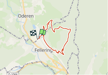
Trail Walking of 6.9 km to be discovered at Grand Est, Haut-Rhin, Oderen. This trail is proposed by argonneuweg.
Description
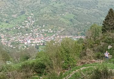
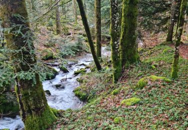
La première partie de cette rando consiste en une montée assez raide au travers des chaumes mais avec des vues splendides sur la vallée et les alentours. Puis une descente douce et longue dans la forêt.
Ne pas oublier les bâtons
Positioning
Country:
France
Region :
Grand Est
Department/Province :
Haut-Rhin
Municipality :
Oderen
Location:
Unknown
Start:(Dec)
Start:(UTM)
349260 ; 5307238 (32T) N.
Comments
Trails nearby
![Trail Walking Linthal - Markstein - Photo](https://media.geolcdn.com/t/375/260/ext.jpg?maxdim=2&url=https%3A%2F%2Fservices.sitytrail.com%2FGeolivesWS%2FDownloadMedia.ashx%3FTrailID%3D266212%26Media%3Dfix__20140413115328.jpg)
![Walking Walking](https://static1.geolcdn.com/sitytour/trail-icons/101.png)
Markstein
Walking
Medium
(1)
Linthal,
Grand Est,
Haut-Rhin,
France
![](/images/other/stat-length.png)
14 km | 19.8 km-effort
4h 45min
![](https://static1.geolcdn.com/siteimages/upload/files/16400158638029165_repeat_loop_refresh_sync_direction_icon.png)
Yes
![Trail Walking Fellering - Felsach _chapelle ST Nicolas_frenz - Photo](https://media.geolcdn.com/t/375/260/ext.jpg?maxdim=2&url=https%3A%2F%2Fstatic1.geolcdn.com%2Fsiteimages%2Fupload%2Ffiles%2F1553511878bg_sport_marche.png)
![Walking Walking](https://static1.geolcdn.com/sitytour/trail-icons/101.png)
Felsach _chapelle ST Nicolas_frenz
Walking
Difficult
(3)
Fellering,
Grand Est,
Haut-Rhin,
France
![](/images/other/stat-length.png)
9.6 km | 16.5 km-effort
3h 45min
![](https://static1.geolcdn.com/siteimages/upload/files/16400158638029165_repeat_loop_refresh_sync_direction_icon.png)
Yes
![Trail On foot Lautenbachzell - Parking Bellevue - Hundsrucken - Markstein - Photo](https://media.geolcdn.com/t/375/260/ext.jpg?maxdim=2&url=https%3A%2F%2Fstatic1.geolcdn.com%2Fsiteimages%2Fupload%2Ffiles%2F1545311037marcheuse_200dpi.jpg)
![On foot On foot](https://static1.geolcdn.com/sitytour/trail-icons/100.png)
Parking Bellevue - Hundsrucken - Markstein
On foot
Medium
(1)
Lautenbachzell,
Grand Est,
Haut-Rhin,
France
![](/images/other/stat-length.png)
9.4 km | 13 km-effort
Unknown
![](https://static1.geolcdn.com/siteimages/upload/files/16400158638029165_repeat_loop_refresh_sync_direction_icon.png)
Yes
![Trail Walking Oderen - 6146369-Chapelle St Nicolas 2 - Photo](https://media.geolcdn.com/t/375/260/ext.jpg?maxdim=2&url=https%3A%2F%2Fstatic1.geolcdn.com%2Fsiteimages%2Fupload%2Ffiles%2F1553511878bg_sport_marche.png)
![Walking Walking](https://static1.geolcdn.com/sitytour/trail-icons/101.png)
6146369-Chapelle St Nicolas 2
Walking
Medium
(1)
Oderen,
Grand Est,
Haut-Rhin,
France
![](/images/other/stat-length.png)
10.9 km | 17.9 km-effort
3h 41min
![](https://static1.geolcdn.com/siteimages/upload/files/16400158638029165_repeat_loop_refresh_sync_direction_icon.png)
Yes
![Trail Walking Oderen - Oderen Bergenbach Langenbach - Photo](https://media.geolcdn.com/t/375/260/ext.jpg?maxdim=2&url=https%3A%2F%2Fmedia.geolcdn.com%2Ff%2F05163254-f106-4300-b7bd-e85eb3e624ac.jpg)
![Walking Walking](https://static1.geolcdn.com/sitytour/trail-icons/101.png)
Oderen Bergenbach Langenbach
Walking
Medium
Oderen,
Grand Est,
Haut-Rhin,
France
![](/images/other/stat-length.png)
7.1 km | 11.6 km-effort
3h 40min
![](https://static1.geolcdn.com/siteimages/upload/files/16400158638029165_repeat_loop_refresh_sync_direction_icon.png)
No
![Trail Walking Mollau - Le rossberg - Photo](https://media.geolcdn.com/t/375/260/ext.jpg?maxdim=2&url=https%3A%2F%2Fmedia.geolcdn.com%2Ff%2Fe1c84c66-d799-45c0-a7df-12e4ffcf0bb2.jpg)
![Walking Walking](https://static1.geolcdn.com/sitytour/trail-icons/101.png)
![Trail Walking Oderen - trek alsacien (1ère étape) - Photo](https://media.geolcdn.com/t/375/260/ext.jpg?maxdim=2&url=https%3A%2F%2Fmedia.geolcdn.com%2Ff%2F787fe892-71a8-4daf-8eb0-6ad69c3ebb22.jpg)
![Walking Walking](https://static1.geolcdn.com/sitytour/trail-icons/101.png)
trek alsacien (1ère étape)
Walking
Medium
Oderen,
Grand Est,
Haut-Rhin,
France
![](/images/other/stat-length.png)
9.2 km | 18.1 km-effort
4h 0min
![](https://static1.geolcdn.com/siteimages/upload/files/16400158638029165_repeat_loop_refresh_sync_direction_icon.png)
No
![Trail Walking Ventron - Rando des Marcheurs..22/02/2024... - Photo](https://media.geolcdn.com/t/375/260/ext.jpg?maxdim=2&url=https%3A%2F%2Fmedia.geolcdn.com%2Ff%2Ff6554992-36c0-4327-9104-b1bea69cd994.jpg)
![Walking Walking](https://static1.geolcdn.com/sitytour/trail-icons/101.png)
Rando des Marcheurs..22/02/2024...
Walking
Very difficult
Ventron,
Grand Est,
Vosges,
France
![](/images/other/stat-length.png)
19.5 km | 31 km-effort
5h 4min
![](https://static1.geolcdn.com/siteimages/upload/files/16400158638029165_repeat_loop_refresh_sync_direction_icon.png)
Yes
![Trail Walking Ventron - Rando les Marcheurs..Col d'Oderen.18 km..715m D+/- - Photo](https://media.geolcdn.com/t/375/260/ext.jpg?maxdim=2&url=https%3A%2F%2Fmedia.geolcdn.com%2Ff%2Ff5fcbaad-3f44-4790-a317-02b01d64beb4.jpg)
![Walking Walking](https://static1.geolcdn.com/sitytour/trail-icons/101.png)
Rando les Marcheurs..Col d'Oderen.18 km..715m D+/-
Walking
Very difficult
Ventron,
Grand Est,
Vosges,
France
![](/images/other/stat-length.png)
18.6 km | 28 km-effort
4h 38min
![](https://static1.geolcdn.com/siteimages/upload/files/16400158638029165_repeat_loop_refresh_sync_direction_icon.png)
Yes