Randonnée Marche Masevaux-Niederbruck - Buchberg - Photo
 helmut68
helmut68

Utilisateur

© OpenStreetMap contributors
Longueur
Longueur
8,5 km
Altitude max
Altitude max
765 m
Dénivelé positif
Dénivelé positif
393 m
Km-Effort
Km-Effort  
13,7 km
Altitude min
Altitude min
399 m
Dénivelé négatif
Dénivelé négatif
395 m
Boucle
Boucle
Oui
Date de création :
2020-01-05 11:04:25.903
Dernière modification :
2020-01-05 16:45:57.151

(0 Avis)

Marche
Marche
2h36
Difficulté : Facile

Scannez ce code QR pour ouvrir la randonnée dans l'application SityTrail

Application GPS de randonnée GRATUITE

Logo SityTrail SityTrail

IGN / Instituts géographiques

Télécharger SityTrail sur l'App Store Télécharger SityTrail sur Google Play

Logo SityTrail SityTrail World

Le monde est à vous

Télécharger SityTrail sur l'App Store Télécharger SityTrail sur Google Play Télécharger SityTrail sur Huawei AppGallery

À propos

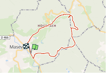
Randonnée Marche de 8,5 km à découvrir à Grand Est, Haut-Rhin, Masevaux-Niederbruck. Cette randonnée est proposée par helmut68.

Description

Départ à la caserne des pompiers de Masevaux , suivre le marquage "triangle jaune" jusqu'au Buchberg ,ensuite le " triangle rouge" jusqu'au Schirm, puis le rectangle " rouge blanc rouge " jusqu'au retour à Masevaux.
Belle petite balade ou l'on peut prendre le  repas tiré du sac sur un banc au Buchberg , sinon un peu plus loin au Rocher du Poilus ( plusieurs tables  ) ou au col du Schirm ( plusieurs tables) .
Alors à vos chaussures.....

Profil altimétrique

Photos

Localisation

Pays :
France
Région :
Grand Est
Département/Province :
Haut-Rhin
Commune :
Masevaux-Niederbruck
Localité :
Masevaux
Départ:(UTM)
350343 ; 5292930 (32T) N.

Randonnées à proximité

Randonnée Marche Masevaux-Niederbruck - Masevaux - Rossberg par le belvédère du Fuchsfelsen - Photo
Marche
Bart2015

Marche

Moyen
(1)
Masevaux-Niederbruck, Grand Est, Haut-Rhin, France
19,9 km | 34 km-effort
4h 44min
Oui
Randonnée Marche Sentheim - Sentheim Rossberg - Photo
Marche
helmut68

Marche

Moyen
(1)
Sentheim, Grand Est, Haut-Rhin, France
27 km | 40 km-effort
6h 11min
Oui
Randonnée Marche Bourbach-le-Haut - Tour du Rossberg - Gsang - Thannerhubel - Photo
Marche
GUIDE
mumu.larandonneuse

Marche

Difficile
Bourbach-le-Haut, Grand Est, Haut-Rhin, France
11,4 km | 18,5 km-effort
4h 12min
Oui
Randonnée Marche Lauw - 2022-07-14 Marche Lauw Refuge CAF Baerenkopf - Photo
Marche
GUIDE
holtzv

Marche

Très difficile
Lauw, Grand Est, Haut-Rhin, France
18,4 km | 31 km-effort
5h 35min
Non
Randonnée A pied Sentheim - Sentier géologique du Wolfloch - Photo
A pied
PRO

A pied

Facile
Sentheim, Grand Est, Haut-Rhin, France
3,8 km | 4,8 km-effort
1h 5min
Non
Randonnée A pied Sentheim - Sentheim - Bergwald - Eichwald - Guevenheim - Sentheim - Photo
A pied
patrickbeyrath

A pied

Facile
(1)
Sentheim, Grand Est, Haut-Rhin, France
13,4 km | 16,6 km-effort
Inconnu
Oui
Randonnée Marche Bitschwiller-lès-Thann - 68 Col du Hundsrück  - FA Gsang - retour ThannerHubel - Photo
Marche

Marche

Moyen
(1)
Bitschwiller-lès-Thann, Grand Est, Haut-Rhin, France
11,2 km | 18,4 km-effort
3h 48min
Oui
Randonnée Marche Masevaux-Niederbruck - Rando CLAS du 25/04/2024 - Photo
Marche
boubou68

Marche

Très difficile
Masevaux-Niederbruck, Grand Est, Haut-Rhin, France
17 km | 28 km-effort
4h 24min
Oui
Randonnée Marche Kirchberg - Rando du 11/04/2024  ..Marcheurs - Photo
Marche
boubou68

Marche

Très difficile
Kirchberg, Grand Est, Haut-Rhin, France
23 km | 37 km-effort
5h 37min
Oui


Fermer
Mes abonnements