Randonnée Marche Sentheim - Haut Soultzbach - Photo
 helmut68
helmut68

Utilisateur

© OpenStreetMap contributors
Longueur
Longueur
17,7 km
Altitude max
Altitude max
429 m
Dénivelé positif
Dénivelé positif
273 m
Km-Effort
Km-Effort  
21 km
Altitude min
Altitude min
320 m
Dénivelé négatif
Dénivelé négatif
277 m
Boucle
Boucle
Non
Date de création :
2020-02-16 10:23:01.687
Dernière modification :
2020-02-17 12:54:03.773

(0 Avis)

Marche
Marche
4h10
Difficulté : Facile

Scannez ce code QR pour ouvrir la randonnée dans l'application SityTrail

Application GPS de randonnée GRATUITE

Logo SityTrail SityTrail

IGN / Instituts géographiques

Télécharger SityTrail sur l'App Store Télécharger SityTrail sur Google Play

Logo SityTrail SityTrail World

Le monde est à vous

Télécharger SityTrail sur l'App Store Télécharger SityTrail sur Google Play Télécharger SityTrail sur Huawei AppGallery

À propos

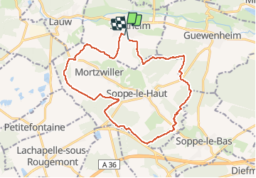
Randonnée Marche de 17,7 km à découvrir à Grand Est, Haut-Rhin, Sentheim. Cette randonnée est proposée par helmut68.

Description

Départ et arrivée place de jeux de Sentheim .Prener la route de Mortzwiller jusqu'en haut de la colline,puis emprunter le chemin à votre drote qui mène dans la forêt.
Suivre le balisage " disque rouge " , " disque jaune "  , " Croix rouge " et enfin le " "triangle bleu " jusqu'à la chapelle " Notre Dame des Bouleaux" . De là suivre le balisage " croix jaune" jusqu'à Sentheim.
Très belle randonnée qui vous fait découvrir le Haut Soultzbach ( communes de Mortzwiller, Soppe le Haut ...) et ses beaux points de vue.
Alors à vos chaussures ...

Profil altimétrique

Photos

Localisation

Pays :
France
Région :
Grand Est
Département/Province :
Haut-Rhin
Commune :
Sentheim
Localité :
Unknown
Départ:(UTM)
353895 ; 5290559 (32T) N.

Randonnées à proximité

Randonnée Marche Masevaux-Niederbruck - Masevaux - Rossberg par le belvédère du Fuchsfelsen - Photo
Marche
Bart2015

Marche

Moyen
(1)
Masevaux-Niederbruck, Grand Est, Haut-Rhin, France
19,9 km | 34 km-effort
4h 44min
Oui
Randonnée Marche Sentheim - Sentheim Rossberg - Photo
Marche
helmut68

Marche

Moyen
(1)
Sentheim, Grand Est, Haut-Rhin, France
27 km | 40 km-effort
6h 11min
Oui
Randonnée Marche Lauw - 2022-07-14 Marche Lauw Refuge CAF Baerenkopf - Photo
Marche
GUIDE
holtzv

Marche

Très difficile
Lauw, Grand Est, Haut-Rhin, France
18,4 km | 31 km-effort
5h 35min
Non
Randonnée A pied Sentheim - Sentier géologique du Wolfloch - Photo
A pied
PRO

A pied

Facile
Sentheim, Grand Est, Haut-Rhin, France
3,8 km | 4,8 km-effort
1h 5min
Non
Randonnée A pied Sentheim - Sentheim - Bergwald - Eichwald - Guevenheim - Sentheim - Photo
A pied
patrickbeyrath

A pied

Facile
(1)
Sentheim, Grand Est, Haut-Rhin, France
13,4 km | 16,6 km-effort
Inconnu
Oui
Randonnée Marche Sentheim - Knapphutte Saegenkopf Hütte - Photo
Marche
helmut68

Marche

Moyen
Sentheim, Grand Est, Haut-Rhin, France
13,8 km | 17,2 km-effort
5h 11min
Oui
Randonnée Marche Sentheim - Montori - Photo
Marche
helmut68

Marche

Moyen
Sentheim, Grand Est, Haut-Rhin, France
17,7 km | 24 km-effort
4h 47min
Oui
Randonnée V.T.T. Sentheim - AperoDioller - Photo
V.T.T.
helmut68

V.T.T.

Facile
Sentheim, Grand Est, Haut-Rhin, France
24 km | 27 km-effort
1h 23min
Oui
Randonnée Marche Sentheim - Baerenkopf  - Photo
Marche
helmut68

Marche

Difficile
Sentheim, Grand Est, Haut-Rhin, France
33 km | 49 km-effort
7h 0min
Oui


Fermer
Mes abonnements