Randonnée V.T.T. Teurthéville-Bocage - Rando des châtaignes - Teurtheville-Bocage - Photo

Rando des châtaignes - Teurtheville-Bocage

 tracegps
tracegps

Utilisateur

© OpenStreetMap contributors
Longueur
Longueur
30 km
Altitude max
Altitude max
115 m
Dénivelé positif
Dénivelé positif
515 m
Km-Effort
Km-Effort  
37 km
Altitude min
Altitude min
28 m
Dénivelé négatif
Dénivelé négatif
515 m
Boucle
Boucle
Oui
Date de création :
2014-12-10 00:00:00.0
Dernière modification :
2014-12-10 00:00:00.0

(0 Avis)

V.T.T.
V.T.T.
2h30
Difficulté : Difficile

Scannez ce code QR pour ouvrir la randonnée dans l'application SityTrail

Application GPS de randonnée GRATUITE

Logo SityTrail SityTrail

IGN / Instituts géographiques

Télécharger SityTrail sur l'App Store Télécharger SityTrail sur Google Play

Logo SityTrail SityTrail World

Le monde est à vous

Télécharger SityTrail sur l'App Store Télécharger SityTrail sur Google Play Télécharger SityTrail sur Huawei AppGallery

À propos

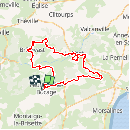
Randonnée V.T.T. de 30 km à découvrir à Normandie, Manche, Teurthéville-Bocage. Cette randonnée est proposée par tracegps.

Description

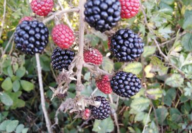
Superbe circuit vallonné avec de beaux passages en sous bois, belle descente de ruisseau. Circuit par moment assez collant pour la saison. Accueil sympa et bon balisage.

Profil altimétrique

Photos

Localisation

Pays :
France
Région :
Normandie
Département/Province :
Manche
Commune :
Teurthéville-Bocage
Localité :
Unknown
Départ:(Dec)
Départ:(UTM)
615612 ; 5494190 (30U) N.

Randonnées à proximité

Randonnée Marche Le Vast - Le long de la Saire - Le Vast - Photo
Marche
tracegps

Marche

Moyen
(4)
Le Vast, Normandie, Manche, France
9,7 km | 12,4 km-effort
3h 0min
Oui
Randonnée V.T.T. Teurthéville-Bocage - Rando des châtaignes 2013 - Teurthéville Bocage - Photo
V.T.T.
tracegps

V.T.T.

Moyen
Teurthéville-Bocage, Normandie, Manche, France
38 km | 47 km-effort
2h 30min
Oui
Randonnée Marche Le Vast - Le long de la vallée de la Sairre - Photo
Marche
yago1404

Marche

Moyen
Le Vast, Normandie, Manche, France
10 km | 12,6 km-effort
2h 40min
Oui
Randonnée Marche Brillevast - Brillevast - Photo
Marche
clrunavot

Marche

Moyen
Brillevast, Normandie, Manche, France
8,1 km | 10 km-effort
2h 45min
Oui
Randonnée Marche Gonneville-le-Theil - murr - Photo
Marche
yoyodutheil

Marche

Très facile
Gonneville-le-Theil, Normandie, Manche, France
4 km | 4,7 km-effort
2h 37min
Non
Randonnée Course à pied Montaigu-la-Brisette - montaigu la brisettte - Photo
Course à pied
mouchelpierre

Course à pied

Très facile
Montaigu-la-Brisette, Normandie, Manche, France
10,7 km | 13,2 km-effort
2h 39min
Oui
Randonnée sport Le Vast - LE VAST-LA PERNELLE - Photo
sport
clrunavot

sport

Très facile
Le Vast, Normandie, Manche, France
5,6 km | 7,1 km-effort
Inconnu
Non
Randonnée Marche Le Vast - raid post 1ere grp 5 - Photo
Marche
Greg_B

Marche

Très difficile
Le Vast, Normandie, Manche, France
61 km | 69 km-effort
15h 45min
Oui
Randonnée Marche Saussemesnil - Saussememil 50 - Photo
Marche
Yvon59

Marche

Difficile
Saussemesnil, Normandie, Manche, France
11,9 km | 13,6 km-effort
3h 12min
Oui


Fermer
Mes abonnements