Trail Mountain bike Teurthéville-Bocage - Rando des châtaignes - Teurtheville-Bocage - Photo

Rando des châtaignes - Teurtheville-Bocage

 tracegps
tracegps

User

© OpenStreetMap contributors
Length
Length
30 km
Max alt
Max alt
115 m
Uphill gradient
Uphill gradient
515 m
Km-Effort
Km-Effort  
37 km
Min alt
Min alt
28 m
Downhill gradient
Downhill gradient
515 m
Boucle
Boucle
Yes
Creation date :
2014-12-10 00:00:00.0
Updated on :
2014-12-10 00:00:00.0

(0 Reviews)

Mountain bike
Mountain bike
2h30
Difficulty : Difficult

Scan this QR Code to open this trail in the SityTrail application

FREE GPS app for hiking

Logo SityTrail SityTrail

IGN / Geographical institutes

Download SityTrail from the App Store Download SityTrail from Google Play

Logo SityTrail SityTrail World

The world is yours!

Download SityTrail from the App Store Download SityTrail from Google Play Download SityTrail on Huawei AppGallery

About

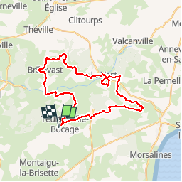
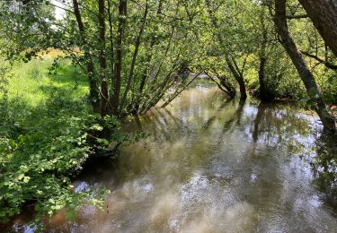
Trail Mountain bike of 30 km to be discovered at Normandy, Manche, Teurthéville-Bocage. This trail is proposed by tracegps.

Description

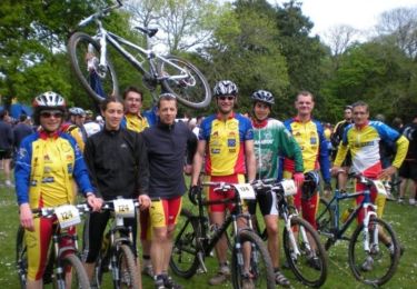
Superbe circuit vallonné avec de beaux passages en sous bois, belle descente de ruisseau. Circuit par moment assez collant pour la saison. Accueil sympa et bon balisage.

Elevation profile

Photos

Positioning

Country:
France
Region :
Normandy
Department/Province :
Manche
Municipality :
Teurthéville-Bocage
Location:
Unknown
Start:(UTM)
615612 ; 5494190 (30U) N.

Trails nearby

Trail Walking Le Vast - Le long de la Saire - Le Vast - Photo
Walking
tracegps

Walking

Medium
(4)
Le Vast, Normandy, Manche, France
9.7 km | 12.4 km-effort
3h 0min
Yes
Trail Mountain bike Teurthéville-Bocage - Rando des châtaignes 2013 - Teurthéville Bocage - Photo
Mountain bike
tracegps

Mountain bike

Medium
Teurthéville-Bocage, Normandy, Manche, France
38 km | 47 km-effort
2h 30min
Yes
Trail Walking Le Vast - Le long de la vallée de la Sairre - Photo
Walking
yago1404

Walking

Medium
Le Vast, Normandy, Manche, France
10 km | 12.6 km-effort
2h 40min
Yes
Trail Walking Brillevast - Brillevast - Photo
Walking
clrunavot

Walking

Medium
Brillevast, Normandy, Manche, France
8.1 km | 10 km-effort
2h 45min
Yes
Trail Walking Gonneville-le-Theil - murr - Photo
Walking
yoyodutheil

Walking

Very easy
Gonneville-le-Theil, Normandy, Manche, France
4 km | 4.7 km-effort
2h 37min
No
Trail Running Montaigu-la-Brisette - montaigu la brisettte - Photo
Running
mouchelpierre

Running

Very easy
Montaigu-la-Brisette, Normandy, Manche, France
10.7 km | 13.2 km-effort
2h 39min
Yes
Trail sport Le Vast - LE VAST-LA PERNELLE - Photo
sport
clrunavot

sport

Very easy
Le Vast, Normandy, Manche, France
5.6 km | 7.1 km-effort
Unknown
No
Trail Walking Le Vast - raid post 1ere grp 5 - Photo
Walking
Greg_B

Walking

Very difficult
Le Vast, Normandy, Manche, France
61 km | 69 km-effort
15h 45min
Yes
Trail Walking Saussemesnil - Saussememil 50 - Photo
Walking
Yvon59

Walking

Difficult
Saussemesnil, Normandy, Manche, France
11.9 km | 13.6 km-effort
3h 12min
Yes


Close
My subscriptions