Tocht Mountainbike Teurthéville-Bocage - Rando des châtaignes - Teurtheville-Bocage - Photo

Rando des châtaignes - Teurtheville-Bocage

 tracegps
tracegps

Gebruiker

© OpenStreetMap contributors
Lengte
Lengte
30 km
Max. hoogte
Max. hoogte
115 m
Positief hoogteverschil
515 m
Km-Effort
Km-Effort  
37 km
Min. hoogte
Min. hoogte
28 m
Negatief hoogteverschil
515 m
Boucle
Boucle
Ja
Datum van aanmaak :
2014-12-10 00:00:00.0
Laatste wijziging :
2014-12-10 00:00:00.0

(0 Bericht)

Mountainbike
Mountainbike
2h30
Moeilijkheid : Moeilijk

Scan deze QR-code om de tocht te openen in de SityTrail-applicatie

Gratisgps-wandelapplicatie

Logo SityTrail SityTrail

IGN / Geografische instituten

SityTrail uit de App Store downloaden SityTrail uit Google Play downloaden

Logo SityTrail SityTrail World

De wereld gaat voor u open

SityTrail uit de App Store downloaden SityTrail uit Google Play downloaden SityTrail op Huawei AppGallery downloaden

Over ons

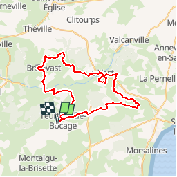
Tocht Mountainbike van 30 km beschikbaar op Normandië, Manche, Teurthéville-Bocage. Deze tocht wordt voorgesteld door tracegps.

Beschrijving

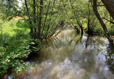
Superbe circuit vallonné avec de beaux passages en sous bois, belle descente de ruisseau. Circuit par moment assez collant pour la saison. Accueil sympa et bon balisage.

Hoogteprofiel

Foto's

Plaatsbepaling

Land:
France
Regio :
Normandië
Departement/Provincie :
Manche
Gemeente :
Teurthéville-Bocage
Locatie:
Unknown
Vertrek:(Dec)
Vertrek:(UTM)
615612 ; 5494190 (30U) N.

Wandeltochten in de omgeving

Tocht Stappen Le Vast - Le long de la Saire - Le Vast - Photo
Stappen
tracegps

Stappen

Medium
(4)
Le Vast, Normandië, Manche, France
9,7 km | 12,4 km-effort
3h 0min
Ja
Tocht Mountainbike Teurthéville-Bocage - Rando des châtaignes 2013 - Teurthéville Bocage - Photo
Mountainbike
tracegps

Mountainbike

Medium
Teurthéville-Bocage, Normandië, Manche, France
38 km | 47 km-effort
2h 30min
Ja
Tocht Stappen Le Vast - Le long de la vallée de la Sairre - Photo
Stappen
yago1404

Stappen

Medium
Le Vast, Normandië, Manche, France
10 km | 12,6 km-effort
2h 40min
Ja
Tocht Stappen Brillevast - Brillevast - Photo
Stappen
clrunavot

Stappen

Medium
Brillevast, Normandië, Manche, France
8,1 km | 10 km-effort
2h 45min
Ja
Tocht Stappen Gonneville-le-Theil - murr - Photo
Stappen
yoyodutheil

Stappen

Heel gemakkelijk
Gonneville-le-Theil, Normandië, Manche, France
4 km | 4,7 km-effort
2h 37min
Neen
Tocht Lopen Montaigu-la-Brisette - montaigu la brisettte - Photo
Lopen
mouchelpierre

Lopen

Heel gemakkelijk
Montaigu-la-Brisette, Normandië, Manche, France
10,7 km | 13,2 km-effort
2h 39min
Ja
Tocht sport Le Vast - LE VAST-LA PERNELLE - Photo
sport
clrunavot

sport

Heel gemakkelijk
Le Vast, Normandië, Manche, France
5,6 km | 7,1 km-effort
Onbekend
Neen
Tocht Stappen Le Vast - raid post 1ere grp 5 - Photo
Stappen
Greg_B

Stappen

Zeer moeilijk
Le Vast, Normandië, Manche, France
61 km | 69 km-effort
15h 45min
Ja
Tocht Stappen Saussemesnil - Saussememil 50 - Photo
Stappen
Yvon59

Stappen

Moeilijk
Saussemesnil, Normandië, Manche, France
11,9 km | 13,6 km-effort
3h 12min
Ja


Sluiten
Mijn abonnementen