Randonnée V.T.C. Bidache - bidache guiche - Photo
 Dan30
Dan30

Utilisateur

© OpenStreetMap contributors
Longueur
Longueur
20 km
Altitude max
Altitude max
43 m
Dénivelé positif
Dénivelé positif
191 m
Km-Effort
Km-Effort  
23 km
Altitude min
Altitude min
-3 m
Dénivelé négatif
Dénivelé négatif
190 m
Boucle
Boucle
Oui
Date de création :
2024-04-12 13:47:16.589
Dernière modification :
2024-04-12 16:08:24.765

(0 Avis)

V.T.C.
V.T.C.
1h38
Difficulté : Facile

Scannez ce code QR pour ouvrir la randonnée dans l'application SityTrail

Application GPS de randonnée GRATUITE

Logo SityTrail SityTrail

IGN / Instituts géographiques

Télécharger SityTrail sur l'App Store Télécharger SityTrail sur Google Play

Logo SityTrail SityTrail World

Le monde est à vous

Télécharger SityTrail sur l'App Store Télécharger SityTrail sur Google Play Télécharger SityTrail sur Huawei AppGallery

À propos

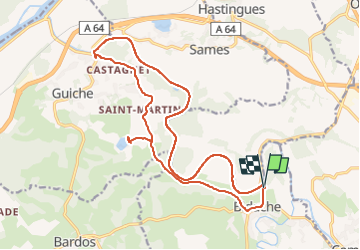
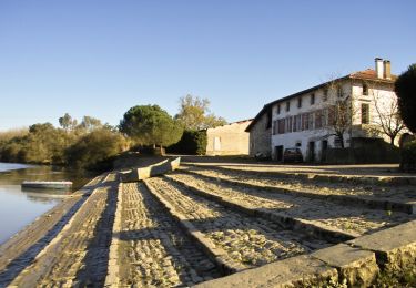
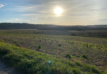
Randonnée V.T.C. de 20 km à découvrir à Nouvelle-Aquitaine, Pyrénées-Atlantiques, Bidache. Cette randonnée est proposée par Dan30.

Description

aller par piste cyclable le long de la bidouze et retour par la route passage a la base de loisir du lac de Guiche

Profil altimétrique

Localisation

Pays :
France
Région :
Nouvelle-Aquitaine
Département/Province :
Pyrénées-Atlantiques
Commune :
Bidache
Localité :
Unknown
Départ:(UTM)
650526 ; 4816807 (30T) N.

Randonnées à proximité

Randonnée Marche Bidache - Bidache Came Boucle Bidouze - Photo
Marche
jaja64

Marche

Très facile
Bidache, Nouvelle-Aquitaine, Pyrénées-Atlantiques, France
11,2 km | 12,9 km-effort
2h 50min
Oui
Randonnée Cheval Came - Came - Pessarou - Photo
Cheval
tracegps

Cheval

Moyen
Came, Nouvelle-Aquitaine, Pyrénées-Atlantiques, France
21 km | 28 km-effort
4h 0min
Non
Randonnée Cheval Came - Came - Sames - Photo
Cheval
tracegps

Cheval

Moyen
Came, Nouvelle-Aquitaine, Pyrénées-Atlantiques, France
41 km | 49 km-effort
8h 0min
Non
Randonnée V.T.T. Bidache - Château et Bidouze - Bidache - Photo
V.T.T.
tracegps

V.T.T.

Moyen
Bidache, Nouvelle-Aquitaine, Pyrénées-Atlantiques, France
11 km | 12,7 km-effort
1h 19min
Oui
Randonnée Marche Bidache - Château et Bidouze - Bidache - Photo
Marche
tracegps

Marche

Difficile
(1)
Bidache, Nouvelle-Aquitaine, Pyrénées-Atlantiques, France
11 km | 12,7 km-effort
3h 10min
Oui
Randonnée Marche Hastingues - Long de la Bidouze - Photo
Marche
bunji

Marche

Facile
Hastingues, Nouvelle-Aquitaine, Landes, France
4 km | 4,4 km-effort
1h 4min
Oui
Randonnée Marche Guiche - Guiche - Photo
Marche
DECHAMPD

Marche

Très facile
Guiche, Nouvelle-Aquitaine, Pyrénées-Atlantiques, France
11 km | 13,6 km-effort
2h 57min
Oui
Randonnée Marche Came - Came - Photo
Marche
isidori

Marche

Facile
Came, Nouvelle-Aquitaine, Pyrénées-Atlantiques, France
6,7 km | 9,2 km-effort
2h 0min
Oui
Randonnée Marche Hastingues - Trace G4 Hastingues Guy - Photo
Marche
mitch1952

Marche

Hastingues, Nouvelle-Aquitaine, Landes, France
10,6 km | 13 km-effort
5h 13min
Oui


Fermer
Mes abonnements