Randonnée Marche nordique Logelheim - AMAELLES - MN 02/05/2024 - Logenlheim/Ste Croix - Photo

AMAELLES - MN 02/05/2024 - Logenlheim/Ste Croix

 Hub6877
Hub6877

Utilisateur

© OpenStreetMap contributors
Longueur
Longueur
6,1 km
Altitude max
Altitude max
201 m
Dénivelé positif
Dénivelé positif
38 m
Km-Effort
Km-Effort  
6,6 km
Altitude min
Altitude min
189 m
Dénivelé négatif
Dénivelé négatif
37 m
Boucle
Boucle
Oui
Date de création :
2024-05-02 06:58:19.56
Dernière modification :
2024-05-14 09:59:41.403

(0 Avis)

Marche nordique
Marche nordique
1h46
Difficulté : Très facile

Scannez ce code QR pour ouvrir la randonnée dans l'application SityTrail

Application GPS de randonnée GRATUITE

Logo SityTrail SityTrail

IGN / Instituts géographiques

Télécharger SityTrail sur l'App Store Télécharger SityTrail sur Google Play

Logo SityTrail SityTrail World

Le monde est à vous

Télécharger SityTrail sur l'App Store Télécharger SityTrail sur Google Play Télécharger SityTrail sur Huawei AppGallery

À propos

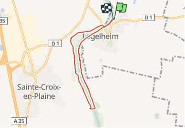
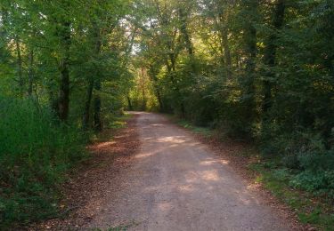
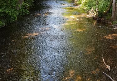
Randonnée Marche nordique de 6,1 km à découvrir à Grand Est, Haut-Rhin, Logelheim. Cette randonnée est proposée par Hub6877.

Description

AMAELLES - Marche Nordique du 02/05/2024 - Logenlheim/Ste Croix
de 9h à 11h
10 participants (Animation: Hubert)
Météo : Couvert - Temp:

Profil altimétrique

Photos

Localisation

Pays :
France
Région :
Grand Est
Département/Province :
Haut-Rhin
Commune :
Logelheim
Localité :
Unknown
Départ:(UTM)
381533 ; 5320210 (32U) N.

Randonnées à proximité

Randonnée Marche Niederhergheim - thannenkirch - Photo
Marche
Eddy Vincent

Marche

Très difficile
Niederhergheim, Grand Est, Haut-Rhin, France
41 km | 52 km-effort
4h 51min
Non
Randonnée V.T.T. Andolsheim - VTT 15/11/22 effectuée  - Photo
V.T.T.
ABICHE

V.T.T.

Facile
(1)
Andolsheim, Grand Est, Haut-Rhin, France
11,6 km | 12,5 km-effort
1h 26min
Non
Randonnée Marche Colmar - Willer sur Thur - Grand Ballon- Willer sur Thur - Photo
Marche
Schaff

Marche

Difficile
Colmar, Grand Est, Haut-Rhin, France
51 km | 0 m-effort
5h 34min
Non
Randonnée Course à pied Colmar - Boucle Dachsbulh Colmar Course  - Photo
Course à pied
zazie

Course à pied

Très facile
Colmar, Grand Est, Haut-Rhin, France
11 km | 12,1 km-effort
1h 1min
Oui
Randonnée Marche Rouffach - Herrlisheim près Colmar et son Fontainebleau  - Photo
Marche
zazie

Marche

Très facile
Rouffach, Grand Est, Haut-Rhin, France
6,5 km | 7,1 km-effort
1h 12min
Oui
Randonnée Marche Colmar - COLMAR - FORÊT DU NEULAND - Photo
Marche
jean-marie.parachini

Marche

Très facile
Colmar, Grand Est, Haut-Rhin, France
5,2 km | 6 km-effort
1h 17min
Oui
Randonnée Vélo Colmar - Première Sortie Sandra et Laurent  - Photo
Vélo
Schaff

Vélo

Moyen
Colmar, Grand Est, Haut-Rhin, France
31 km | 33 km-effort
1h 58min
Oui
Randonnée Course à pied Colmar - Run du matin en forêt de Neuland - Colmar - Photo
Course à pied
tracegps

Course à pied

Facile
Colmar, Grand Est, Haut-Rhin, France
6,8 km | 7,6 km-effort
45min
Oui
Randonnée V.T.T. Widensolen - Vélo avec pet  - Photo
V.T.T.
juliengsell

V.T.T.

Facile
Widensolen, Grand Est, Haut-Rhin, France
10,1 km | 10,8 km-effort
1h 4min
Oui


Fermer
Mes abonnements