Randonnée V.T.T. Nice - Prom Cagnes Nice port - Photo
 GrouGary
GrouGary

Utilisateur

© OpenStreetMap contributors
Longueur
Longueur
14,7 km
Altitude max
Altitude max
24 m
Dénivelé positif
Dénivelé positif
120 m
Km-Effort
Km-Effort  
16,4 km
Altitude min
Altitude min
0 m
Dénivelé négatif
Dénivelé négatif
135 m
Boucle
Boucle
Non
Date de création :
2015-07-05 00:00:00.0
Dernière modification :
2015-07-05 00:00:00.0

(1 Avis)

V.T.T.
V.T.T.
57m
Difficulté : Facile

Scannez ce code QR pour ouvrir la randonnée dans l'application SityTrail

Application GPS de randonnée GRATUITE

Logo SityTrail SityTrail

IGN / Instituts géographiques

Télécharger SityTrail sur l'App Store Télécharger SityTrail sur Google Play

Logo SityTrail SityTrail World

Le monde est à vous

Télécharger SityTrail sur l'App Store Télécharger SityTrail sur Google Play Télécharger SityTrail sur Huawei AppGallery

À propos

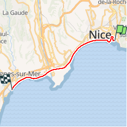
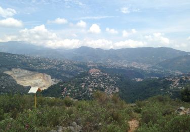
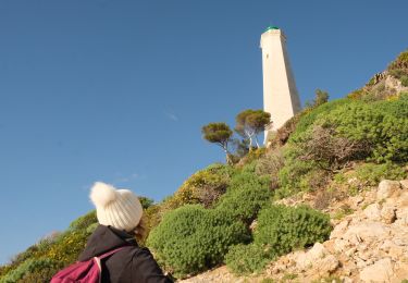
Randonnée V.T.T. de 14,7 km à découvrir à Provence-Alpes-Côte d'Azur, Alpes-Maritimes, Nice. Cette randonnée est proposée par GrouGary.

Description

VTT ss canicule

Profil altimétrique

Localisation

Pays :
France
Région :
Provence-Alpes-Côte d'Azur
Département/Province :
Alpes-Maritimes
Commune :
Nice
Localité :
Unknown
Départ:(Dec)
Départ:(UTM)
362052 ; 4839346 (32T) N.

Commentaires

Veuillez vous connecter pour laisser un commentaire ou une note


pb de connexion ? circuit invalide. ras le bol


Randonnées à proximité

Randonnée Marche Nice - Ballade chemin des douaniers Nice-Villefranche  - Photo
Marche
coriace

Marche

Très facile
(1)
Nice, Provence-Alpes-Côte d'Azur, Alpes-Maritimes, France
7,9 km | 10,3 km-effort
2h 13min
Non
Randonnée Marche Nice - Collines niçoises - Photo
Marche
kenhava

Marche

Facile
(1)
Nice, Provence-Alpes-Côte d'Azur, Alpes-Maritimes, France
21 km | 30 km-effort
6h 32min
Non
Randonnée Marche Saint-Jean-Cap-Ferrat - Cap Ferrat 2011-10-27 - Photo
Marche
Cricounet84

Marche

Moyen
(2)
Saint-Jean-Cap-Ferrat, Provence-Alpes-Côte d'Azur, Alpes-Maritimes, France
10,9 km | 14 km-effort
4h 0min
Oui
Randonnée Marche Saint-Jean-Cap-Ferrat - w-frankrijk-tour-du-cap-ferrat - Photo
Marche
gpstracks

Marche

Très facile
(1)
Saint-Jean-Cap-Ferrat, Provence-Alpes-Côte d'Azur, Alpes-Maritimes, France
6,5 km | 8,6 km-effort
Inconnu
Non
Randonnée Marche Saint-Jean-Cap-Ferrat - Tour du Cap Ferrat - Photo
Marche
tracegps

Marche

Moyen
(4)
Saint-Jean-Cap-Ferrat, Provence-Alpes-Côte d'Azur, Alpes-Maritimes, France
8,9 km | 11,2 km-effort
2h 0min
Oui
Randonnée Marche Nice - Nice - Tour du Mont Boron - Photo
Marche
LightStalker

Marche

Facile
Nice, Provence-Alpes-Côte d'Azur, Alpes-Maritimes, France
7,3 km | 10,5 km-effort
2h 48min
Oui
Randonnée Marche Nice - Balade Niçoise : Centre-Ville, Vieux-Nice, Le Port - Photo
Marche
LightStalker

Marche

Très facile
Nice, Provence-Alpes-Côte d'Azur, Alpes-Maritimes, France
5,4 km | 7,2 km-effort
2h 30min
Oui
Randonnée Marche Saint-Jean-Cap-Ferrat - Cap Ferrat - Photo
Marche
Jean-François Thibaud

Marche

Moyen
Saint-Jean-Cap-Ferrat, Provence-Alpes-Côte d'Azur, Alpes-Maritimes, France
8,2 km | 11 km-effort
3h 20min
Non
Randonnée Marche Villefranche-sur-Mer - Tour de St Jean/ des Marinières 12km - Photo
Marche
Renefrt

Marche

Facile
(1)
Villefranche-sur-Mer, Provence-Alpes-Côte d'Azur, Alpes-Maritimes, France
12,3 km | 15,2 km-effort
3h 26min
Oui


Fermer
Mes abonnements