Randonnée Marche Lauw - 2018 03 08 Lauw - Masevaux R - Photo

2018 03 08 Lauw - Masevaux R

 E.BURCK
E.BURCK

Utilisateur

© OpenStreetMap contributors
Longueur
Longueur
12,9 km
Altitude max
Altitude max
564 m
Dénivelé positif
Dénivelé positif
293 m
Km-Effort
Km-Effort  
16,8 km
Altitude min
Altitude min
372 m
Dénivelé négatif
Dénivelé négatif
292 m
Boucle
Boucle
Oui
Date de création :
2019-05-22 16:12:23.068
Dernière modification :
2019-05-22 16:12:23.153

(0 Avis)

Marche
Marche
3h40
Difficulté : Moyen

Scannez ce code QR pour ouvrir la randonnée dans l'application SityTrail

Application GPS de randonnée GRATUITE

Logo SityTrail SityTrail

IGN / Instituts géographiques

Télécharger SityTrail sur l'App Store Télécharger SityTrail sur Google Play

Logo SityTrail SityTrail World

Le monde est à vous

Télécharger SityTrail sur l'App Store Télécharger SityTrail sur Google Play Télécharger SityTrail sur Huawei AppGallery

À propos

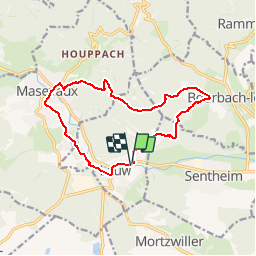
Randonnée Marche de 12,9 km à découvrir à Grand Est, Haut-Rhin, Lauw. Cette randonnée est proposée par E.BURCK.

Description

De Lauw vers Masevaux en passant par le gros chêne à l'aller et le lac bleu au retour. 270 m de dénivelé et 11.5 km au total.
ACCÈS:
-Sur la D466, par Guewenheim, Sentheim puis Lauw.      
PARKING:
-parking sur la gauche de la route principale, peu après l'entrée de Lauw.
 47.757657,   7.025073  
N 47°45'28"  E 7°01'30"  
RESTAURATION :  
Restaurant: Au Relais de la Poste à Masevaux. Tél. 03 89 38 80 97  

Profil altimétrique

Localisation

Pays :
France
Région :
Grand Est
Département/Province :
Haut-Rhin
Commune :
Lauw
Localité :
Unknown
Départ:(Dec)
Départ:(UTM)
351995 ; 5291250 (32T) N.

Randonnées à proximité

Randonnée Marche Masevaux-Niederbruck - Masevaux - Rossberg par le belvédère du Fuchsfelsen - Photo
Marche
Bart2015

Marche

Moyen
(1)
Masevaux-Niederbruck, Grand Est, Haut-Rhin, France
19,9 km | 34 km-effort
4h 44min
Oui
Randonnée Marche Sentheim - Sentheim Rossberg - Photo
Marche
helmut68

Marche

Moyen
(1)
Sentheim, Grand Est, Haut-Rhin, France
27 km | 40 km-effort
6h 11min
Oui
Randonnée Marche Lauw - 2022-07-14 Marche Lauw Refuge CAF Baerenkopf - Photo
Marche
GUIDE
holtzv

Marche

Très difficile
Lauw, Grand Est, Haut-Rhin, France
18,4 km | 31 km-effort
5h 35min
Non
Randonnée A pied Sentheim - Sentier géologique du Wolfloch - Photo
A pied
PRO

A pied

Facile
Sentheim, Grand Est, Haut-Rhin, France
3,8 km | 4,8 km-effort
1h 5min
Non
Randonnée A pied Sentheim - Sentheim - Bergwald - Eichwald - Guevenheim - Sentheim - Photo
A pied
patrickbeyrath

A pied

Facile
(1)
Sentheim, Grand Est, Haut-Rhin, France
13,4 km | 16,6 km-effort
Inconnu
Oui
Randonnée Marche Masevaux-Niederbruck - Rando CLAS du 25/04/2024 - Photo
Marche
boubou68

Marche

Très difficile
Masevaux-Niederbruck, Grand Est, Haut-Rhin, France
17 km | 28 km-effort
4h 24min
Oui
Randonnée Marche Sentheim - Knapphutte Saegenkopf Hütte - Photo
Marche
helmut68

Marche

Moyen
Sentheim, Grand Est, Haut-Rhin, France
13,8 km | 17,2 km-effort
5h 11min
Oui
Randonnée Marche Sentheim - Montori - Photo
Marche
helmut68

Marche

Moyen
Sentheim, Grand Est, Haut-Rhin, France
17,7 km | 24 km-effort
4h 47min
Oui
Randonnée V.T.T. Sentheim - AperoDioller - Photo
V.T.T.
helmut68

V.T.T.

Facile
Sentheim, Grand Est, Haut-Rhin, France
24 km | 27 km-effort
1h 23min
Oui


Fermer
Mes abonnements